By Aileen Buckley, Mapping Center Lead
We got an interesting comment on our Ask a Cartographer page the other day that I thought we could explore in a little more detail here. The question was, “Why does the Esri software allow users to place scale bars on non projected data? Results are especially bogus as regions approach the poles.” It is certainly true that there are some instances in which the use of a scale bar is not advisable. However, it is not a good idea to impose these kinds of constraints on the map maker, for example, through the available software options. As a matter of fact, there are some instances in which the use of a scale bar is acceptable for maps that have “non projected” data and projections that have a lot of distortion towards the poles.
First let’s explore the “non projected” data aspect relative to the use of a scale bars on the map. For the most part, “non projected” data is really data in a geographic coordinate system rather than a projected coordinate system. In fact, when “non-projected” geographic coordinate system data are displayed in ArcMap, they are shown with a modified Plate Carree’ map projection, with increasing e-w scale distortion from Equator to Pole, but with no north-south scale distortion.
For maps that use a geographic coordinate system, it is acceptable to include a scale bar if the map is at a large enough scale – as a rule, 1:250,000 or larger. For these types of maps, distortion across the map is minimal enough that a scale bar can be used to measure distances with acceptable accuracy. This, of course, assumes that the mapped area is not in a location of extreme distortion.
To further modify the use of a scale bar on a large scale map with data in a geographic coordinate system, a grid coordinate system in units that make sense in the measurement of distance (e.g., meters or feet) would advisably be superimposed over the data which is in its native geographic coordinate system. This is akin to adding a grid to the map in ArcMap (this is a property of the data frame). So, for example, you could superimpose a UTM or State Plane grid over a map that is drawn in ArcMap with a geographic coordinate system. Then the map reader could use the scale bar, in meters for the UTM grid and feet for the State Plane grid, to measure distances.
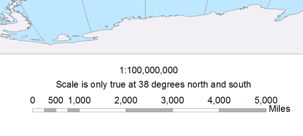
Now let’s explore the “distortion towards the poles” aspect relative to the inclusion of a scale bar on the map. It is sometimes acceptable to include a scale bar on a map that has distortion due to the convergence of the meridians towards the poles. In general, you will see this done on maps that are not in a geographic coordinate system but rather in a projected coordinate system for the extent of the world (e.g., Robinson or Mollweide). In these cases, the map maker must clarify for the reader the appropriateness of the scale bar.
One way to do this is to include a note stating that the scale is only true along the line of tangency or lines of secancy (of course, this is restated in a more consumable way for map readers as we do not generally assume that they understand this property of map projections). For example, you might see a note on a map with the Robinson projection that scale is only true along the 38th parallels (that is, lines of latitude) north and south (the homolatitudes used as the standard parallels for this projection). Of course, the problem is that we usually do not show these parallels on small scale maps; rather, we might show the 30th or 40th parallels and then allow the map reader to interpolate the location of the 38th parallels. Additionally, we expect the map reader to be able to understand what that restriction on scale bar use means about measuring distance at any location other than the lines of tangency — a huge leap for even the most experienced map reader much less the more nascent ones.
So you should be able to see now why it is usually NOT a good idea to use a scale bar on a small scale map — the statement of appropriate use usually pertains to parallels that are not shown on the map, and it is difficult for the reader to understand how to use the scale bar in any location OTHER than along the lines of tangency.
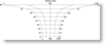
Alternatively, you will sometimes see the use of a variable scale bar (a set of scale bars aligned horizontally that relate to the scale along selected parallels). However, there is actually only type of map on which it is appropriate to use a variable scale bar — a map with a cylindrical projection that is conformal in the normal aspect. The most commonly used map that meets these qualifications is a map with the Mercator projection. If you have seen this used on any other type of map, it most likely was used incorrectly. The reason it works for maps with the Mercator projection is that scale varies systematically in the north-south direction (i.e., along the parallels), and the projection is conformal so distortion in any direction is the same at a given latitude.
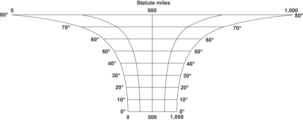
Theoretically, you could also make a variable scale bar for a map with the Lambert Conformal Conic projection in the normal aspect but the lines would be circular arcs which would make distance measurement difficult. Or you could make one for a stereographic azimuthal projection but the lines would be circles, again making distance measurements difficult. But it would actually work because these projections are conformal and therefore scale varies systematically in all directions along a parallel. Further, you could use a variable scale bar for a transverse or oblique aspect Mercator projection, but it would be hard for users to interpret since it would be a rotated version of the normal aspect variable scale bar showing that scale increases away from the central meridian or great circle line of tangency.
So, given the difficulty of using the variable scale bar in any but the Mercator case, in reality, the only instance in which distance could be measured easily on a variable scale bar is on a map with the Mercator projection. This is another indication of why you should be extremely careful in determining whether or not to include a scale bar, such as a variable scale bar, on a small scale map.
So you should be able to see now why it is usually NOT a good idea to use a scale bar on any small scale map including one that uses a geographic coordinate system:
- The statement of appropriate use usually pertains to parallels that are not shown on the map, and it is difficult for the reader to understand how to use the scale bar in any location OTHER than along the lines of tangency.
- The appropriate use of a variable scale bar is, for practical reasons, limited only to maps with a Mercator projection.
In summary, it is best if we at Esri offer map makers the option to include scale bars on any map, but it is incumbent upon the map maker to understand what the appropriate uses are and to know how to mitigate the potential for map readers to use the scale bar inappropriately. And clearly, there are very few instances when it is really the best idea to include a scale bar on any small scale map. But now you know exactly why!
To learn more about scale bars, check out these previous blog posts:
Thanks to Melita Kennedy, Senior Product Engineer for Map Projections and Transformations, and A. Jon Kimerling, Professor Emeritus at Oregon State University, for their help with this blog entry.


Article Discussion: