
The Jane Goodall Institute Implements GIS in Local Contexts to Help Communities Regenerate Woodlands
 protects wild chimpanzees in and around Gombe National Park in Tanzania. (Image courtesy of JGI.)")
Dr. Jane Goodall has been conducting pioneering research on chimpanzees in Tanzania for more than 55 years. The Jane Goodall Institute (JGI) continues Dr. Goodall’s research to this day, collecting data on chimpanzee behavior in Gombe National Park via the Gombe Stream Research Center. JGI’s research partners—including Duke University, the University of Minnesota, Arizona State University, Franklin & Marshall College, and George Washington University—digitize, manage, and analyze the information to advance our knowledge of chimpanzees, basic science, and conservation.
Almost 25 years ago, however, Dr. Goodall wondered how the Gombe chimpanzees would survive. While flying in a small plane over Gombe, she saw the almost total loss of forest and woodlands around the park.
“There’s no way we can even attempt to save these precious Gombe chimpanzees unless we could improve the lives of the people living around that last little oasis of forest,” she recalled recently in an interview with National Public Radio (NPR).
Since then, JGI has been working with individual farmers, local communities, and governments—along with science and geospatial technology partners—to learn how to design more sustainable landscapes. GIS initially allowed JGI to put people, chimpanzees, and habitat data on the same map. Now, new technologies and very high-resolution imagery—integrated with ArcGIS—are enabling JGI to closely monitor geodesign processes and apply appropriate methodologies to local contexts.
With all these efforts combined, many of the woodlands outside Gombe are coming back. And local communities themselves are managing the forest’s natural regeneration.
A History of Helping Local Communities Restore Woodlands
To halt the rapid deterioration of natural resources, JGI began working with the local communities around Gombe in 1994 through the Lake Tanganyika Catchment Reforestation and Education (TACARE) project. TACARE sought the local community’s support from the beginning by incorporating clean water, agriculture, health, social infrastructure, and community development elements into its conservation programs.
In 2000, JGI began utilizing geospatial technologies to put everything—people, chimpanzees, and habitats—on one map. The organization and its partners integrated more than 400,000 Gombe chimpanzee observations into a geodatabase using Esri’s ArcInfo software. At the same time, analysis of Landsat multispectral scanner (MSS), Landsat Enhanced Thematic Mapper Plus (ETM+), and SPOT satellite images confirmed that while forest cover improved inside Gombe between 1972 and 2003, more than 64 percent of forests and woodlands in core chimpanzee range outside the park had been lost.

JGI’s community-centered approach entered a new era in 2002 when the first one-meter, high-resolution IKONOS imagery of the larger Gombe ecosystem became available. For the first time, JGI staff and partners could look at one image and see trees that chimpanzees use alongside the farms and other lands that are key to people’s livelihoods. This enabled everyone—from villagers and government decision-makers to scientists and conservation practitioners—to gain a common understanding of the landscape, agree on what its major threats are, and work together to save Gombe and the surrounding forests.
In 2005, JGI started incorporating geodesign and conservation action planning (CAP) into its Gombe conservation initiatives. These complementary methodologies bring together people, indigenous understanding, scientific expertise, data, and technology to develop better conservation strategies that are informed by a landscape’s physical, biological, social, political, and economic fabric.
For instance, one of JGI’s strategies is to advocate that local communities plant trees and set up nurseries to source their firewood and timber. But geospatial data analyzed using the CAP process revealed that much of the deforestation that threatened chimpanzee habitats outside Gombe was happening because local communities were clearing these woodlands to make land available for farming and scattered housing—not to collect firewood. Thus, while planting trees and establishing nurseries could support people’s livelihoods, these actions did not remove the most direct threats to the forested areas used by chimpanzees, nor did they address the conservation issue entirely.
So JGI facilitated the development of participatory village land-use plans and community-managed village forest reserves. The aim was to assure land tenure and define appropriate land uses that would both satisfy local residents’ rural development goals and protect chimpanzee habitats outside Gombe.
Evaluating Results with Geodesign
Conservation organizations need to continually measure their results to keep their world views in check and be able to adapt and fine-tune their strategies. This also helps them maintain focus on their main conservation objectives, which in JGI’s case is protecting wild chimpanzees and their habitats. The geodesign process leverages geospatial technologies to directly integrate evaluation into landscape design workflows.
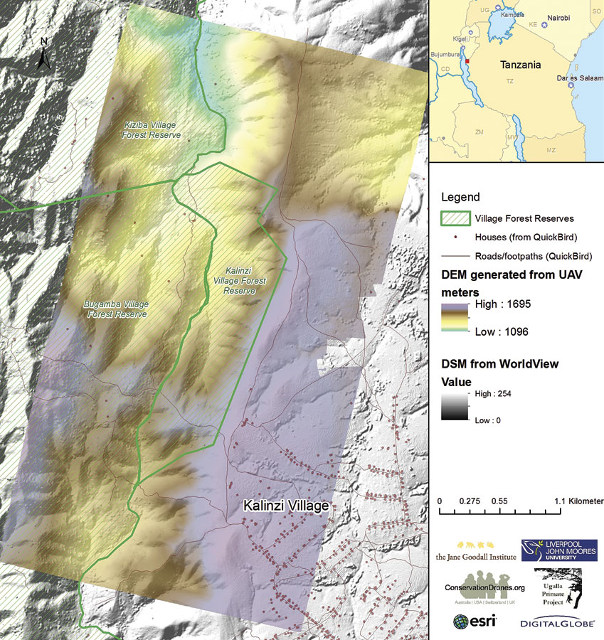
Recently, Esri partner DigitalGlobe acquired very high-resolution imagery of what is now known as the Greater Gombe Ecosystem—the area that covers Gombe and adjacent village lands. With Esri’s help, JGI integrated this and other imagery provided by satellite and unmanned aerial vehicle (UAV) sensors with the ArcGIS platform to support its geodesign process for the area.
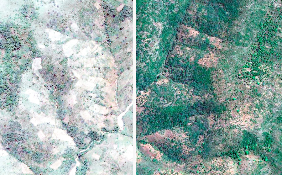
Using 2005 and 2014 DigitalGlobe satellite data in ArcGIS Online, for example, JGI staff can visualize—and share with the world—that Kigalye Village has successfully implemented a land-use plan in its village forest reserve that minimizes farming, logging, and fires and allows Miombo woodlands (which are the most extensive habitats available to Tanzania’s chimpanzees) to regenerate naturally.
JGI staff can also use the geodesign evaluation tools in GeoPlanner for ArcGIS to clearly show the results of its analysis to decision-makers. For example, Landsat MSS and historical aerial photos show that, in 1972, the area now represented by the Kigalye Village Forest Reserve had 370 hectares of woodlands (70 percent of its total area), while in 2005—when the village reserve was created—its woodlands had decreased to 156 hectares, just 42 percent of the forested area recorded in 1972. The imagery also shows that by 2014, community efforts had increased these woodlands to 302 hectares, or about 82 percent of the forested area documented in 1972.
This integration of imagery with the ArcGIS platform—and especially GeoPlanner—makes it easy for decision-makers to see the impact of village-specific land-use plans. It also helps measure the success of conservation initiatives, starting at the village level and going up to the scale of the whole landscape.

Cultivating Local Leaders’ Decision-Making Capacity
To empower local communities to be stewards of their environment and active participants in chimpanzee conservation, JGI galvanized local communities to implement land-use plans for their village forest reserves.
Equipped with Android smartphones and tablets that contain Open Data Kit (ODK), an open-source mobile app, village forest monitors regularly survey their forest reserves and collect data on how many kilometers they patrol, which types of wildlife they see, any chimpanzee presence they observe, and illegal human activities they witness that are threats to wildlife or forests.
JGI started out using ODK in 2009 in 12 villages and has since expanded this work to 52 villages. With the amount of community-generated data continually increasing, it has become difficult to make it accessible to local decision-makers—including village, district, and regional governments—so they can use the results to inform local conservation decisions. So in collaboration with Esri partner Blue Raster, JGI developed the Community Forest Monitoring Dashboard, which leverages ArcGIS Online and ArcGIS for Server to publish this data as maps and interactive charts that are accessible online—even with poor Internet connectivity.
The custom data harvesting system transfers the data recorded in ODK to ArcGIS Online, enhancing it with the rich cartography, spatial analysis and data visualization tools, and amplified security that come with the ArcGIS platform. As a client-side app that was built using the React isomorphic JavaScript framework, which allows both the server and front-facing sides of the app to share the same code, the system can perform in low-bandwidth environments under challenging conditions. The combination of technologies also enables this system to be augmented with capabilities such as administering alerts and processing outside data sources. It is compatible with other Esri tools as well, such as Esri Story Map apps and AppStudio for ArcGIS.
JGI, Blue Raster, local and regional government officials, and other partners launched the Community Forest Monitoring Dashboard in Kigoma, Tanzania, in January 2016. With the dashboard, local decision-makers can now use community data to evaluate the implementation of village land-use plans. Zooming in to Kigalye Village, for example, decision-makers can see not only how thoroughly the Kigalye Forest Reserve is being patrolled but also how often wildlife is encountered and how frequently illegal activities take place. Local leaders can also print maps and browse photos recorded by village forest monitors to get a more detailed impression of activity in the area.
Using UAVs to Capture Village-Scale Imagery
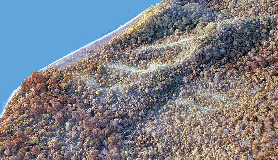
Looking to the future, emerging UAV technologies have the potential to be powerful, locally available tools that JGI staff in Kigoma and communities around Gombe could use to acquire village-scale imagery to evaluate village land-use plans and measure conservation successes. In collaboration with nonprofit Conservation Drones, Liverpool John Moores University, the Ugalla Primate Project, and the local communities, JGI has been assessing the feasibility of using UAVs to complement village forest monitoring efforts and survey chimpanzee nests in western Tanzania.
In June 2015, with support from NASA and the US Fish and Wildlife Service, Conservation Drones trained JGI staff in Kigoma in the use of UAVs. In just two days, with participation from the local communities, JGI successfully acquired very high-resolution imagery of three village forest reserves in rugged terrain along the East African Rift Valley escarpment that lies to the northeast of Gombe. JGI is now working with Esri to use Drone2Map for ArcGIS to streamline the creation of high-resolution imagery products from drone-captured still images. While this will further support the geodesign effort across the ArcGIS platform, the app also shows great promise for improving the automatic classification of tree species.
The Future of Thriving Conservation Efforts
The technological developments that have taken place since JGI began working with the local communities around Gombe to conserve forests and woodlands are very exciting. GIS, with a focus on geodesign, has already helped plan, implement, and evaluate community conservation efforts in the Greater Gombe Ecosystem—and will continue to do so.
“This is one of the first geodesign projects we’ve seen progress from conceptualization to implementation,” said Shannon McElvaney, global industry manager for community development at Esri. “What makes this project extremely special is the dynamic use of geodesign as a tool for adaptive management—to monitor progress and change plans as needed—to ensure that the collective goals of the communities involved were met.”
As long as conservation professionals persist in applying these tools and methodologies within the local context, according to the geodesign framework, conservation efforts will keep thriving in and around Gombe, and even around the world.
About the Author
Dr. Lilian Pintea has spent more than 20 years applying remote sensing and GIS to the task of protecting chimpanzees and their vanishing habitats in Africa. As vice president of conservation science at the Jane Goodall Institute, he shapes the organization’s agenda for applied research to innovate and discover new solutions to maximize the impact of all JGI programs in protecting the environment—especially chimpanzees and their habitats. For more information, email Dr. Pintea.
This work is made possible by the generous support of the American people through the United States Agency for International Development (USAID) and the government of Tanzania. Special thanks go to Esri staff members Gerald Kinn, Kurt Schwoppe, Jim Michel, Greg Pleiss, Robert Stauder, Joseph Peters, and Mark Romero for helping the Jane Goodall Institute leverage the ArcGIS platform to help protect chimpanzees and their habitats.
