Esri partners around the world are taking GIS into new and growing markets, spawning entirely new groups of users. Their focused solutions and apps help nonprofits, companies, and governments reduce costs, increase efficiencies, and make data available to staff and citizens on any device.
Getting County Mapping Apps to Staff, Residents

Roanoke County, Virginia, wanted to better serve its staff and citizens by opening up its GIS data. The county needed to come up with a comprehensive mapping app for its employees, as well as simple, focused mapping apps for residents.
GIS staff at the county worked with GISinc to create a solution. Using GISinc’s OneView, an HTML5/JavaScript app, the team built an online portal that operates as a robust GIS viewer. Through this, county staff members can access Roanoke’s rich datasets using sophisticated visualization controls and query tools.
The team also developed business-specific apps such as TaxView, GovView, VoterView, and Site Selector, which let the public search for information about property taxes, government services (like trash pickup schedules), polling locations, and buildings and sites available for businesses. To make these apps easy to use, GISinc customized the search bars to autocomplete based on multiple data fields and feature classes, such as address, parcel ID, owner name, and place-name.
Because of these apps, Roanoke County has saved hundreds of work hours on field data collection. The county can also deliver information more quickly to users, which is improving customer service. The apps have helped save lives as well: emergency personnel have used them to locate hikers stranded on the Appalachian Trail.
The county’s new public-facing online portal allows the public to go to one place to find detailed information about county services, which saves people time. Residents can also find what they need 24 hours a day, 7 days a week, on many types of devices.
Roanoke County has seen upshots to this kind of citizen engagement too: the Real Estate Valuation office alone has experienced a 79 percent reduction in calls to the customer service department.
Planning for Storm Water Runoff Using GIS

When Rapid City, South Dakota, needed a new drainage plan, city engineers turned to Ferber Engineering Company to implement the Box Elder Drainage Basin Design Plan (BEDBDP), which aimed to improve how the city controlled storm water runoff in the Box Elder Drainage Basin.
The goal was to help local agencies, engineers, and developers efficiently construct drainage facilities for this large watershed area. To achieve this, the plan focused on sizing the system appropriately during development, which would help the city avoid additional costs to retrofit it later.
As part of the BEDBDP, Ferber used ArcGIS to help model and analyze major drainage routes that need protection, as well as locations where drainage facilities are needed to adequately manage storm water runoff throughout the basin. The study area covered about 1,200 acres across two cities and counties and contained hundreds of subbasins, conveyance elements (such as streams or pipes), junctions, and retention centers.
Ferber had to be extremely careful when managing the details of each of these elements and analyzing their complex interactions. In ArcGIS, the team employed imagery analysis tools to calculate impervious areas and spatial analysis tools to investigate soils, flow rates, and other factors. Ferber also applied 3D tools to analyze lidar, surface, and elevation data.
Once the modeling and analysis were complete, Ferber used Data Driven Pages in ArcGIS to present summary data for each element of the design plan. It also put together story maps to share the plan and any historical information with users across the city.
The BEDBDP has helped Rapid City more effectively determine where capital improvement projects are needed. And because the city manages the data using a web-based platform, staff can access information digitally on any device, rather than having to bring binders with paper copies into the field.
“Engineers now have everything in their pocket,” said Linda Foster, Ferber Engineering’s GIS manager.
Locating Grocery Store Expansions Across the Nation

To help retail real estate companies with site selection and market planning, Beitz and Daigh Geographics created Planned Grocery, an app that finds and tracks planned locations for new grocery stores across the United States.
With the app—which runs in ArcGIS Online and is accessible via desktops and mobile devices—users can research grocery store locations that are proposed, planned, or under construction or have been built in the previous six months. The existing grocery store layers (with store identification numbers) are provided by another Esri partner, AggData, and the app lists the location, status, and square footage for each development, as well as the average daily traffic and demographics of the surrounding areas.
Knowing when and where a competitive store will open—and being able to quickly and easily assess basic demographics within certain drive times—helps grocery retailers retain their existing customers and plan for any new store’s impact on sales. That is why companies such as Wegmans, MTN RetailAdvisors, Ram Realty Services, and Lowes Foods have invested in the app.
The corporate office of one leading natural food grocer used Planned Grocery for several months and liked it so much that it offered the app to the company’s regional offices. More than half of these offices adopted it within the first month.
Users report that being able to see the locations of planned grocery stores alongside existing ones speeds up their site selection process. In addition, shopping center brokers are using the app to keep clients informed of market activity that may affect acquisition and disposition decisions.
Mapping Out Royalty Collections in the Music Business
Whenever music is played publicly—at concerts or music festivals, as background music at shopping centers, or in movies and video games—the artists are supposed to receive royalty payments. But all these public performances can be difficult to track.
Société des Auteurs Compositeurs et Editeurs de Musique (SACEM) is a nonprofit in France that helps music creators collect the royalties owed to them when their works are played in public. SACEM negotiates licensing rights and distributes royalty payments to creators.
About 200 employees working from more than 70 locations across France collect general rights payments. These payments make up almost a quarter of SACEM’s income. Facing strong growth in digital distribution and the use of background music, SACEM’s goal for 2015–2016 was to improve its general rights collection tools so it could better serve society members.
At the end of 2015, SACEM recruited Sword Group and Esri France to apply GIS to its operations. The nonprofit focused on adopting GIS at three different levels: national planning, campaigns for individual regions or sectors, and real-time updates from the field.
 on their phones.")
For national planning, Sword used ArcGIS API for JavaScript to build a web app for SACEM. The organization now uses Esri Business Analyst Desktop together with Esri’s geocoding tools and segmentation data to define goals at the national level for all the regional teams. Once those teams receive this guidance, they can refine the goals to better suit their specific objectives. They can also establish campaigns that focus on individual sectors, such as hotels.
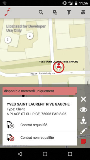
Employees can then take campaign information into the field using a mobile app that Sword built with ArcGIS Runtime SDK for Android. With the app, users can see the locations of client businesses, as well as geocode locations that haven’t been captured yet. They can also view and edit facts about clients, such as the status of their contracts and their hours of operation.
These tools have been widely adopted across SACEM, and users are very satisfied. In particular, the mobile app has helped employees more efficiently collect licensing rights in the field.
Esri’s more than 2,300 global partners provide customer-focused, geoenabled solutions that span dozens of industries. Products and services range from configured apps and custom-built solutions to complete ArcGIS system implementations and content. To search and discover partners, solutions, and services that meet your needs, visit esri.com/partners.