Tech Time

Do you need to build and support native apps for multiple platforms? Esri will soon release AppStudio for ArcGIS, now in beta, which will make the process much easier.
Watch the video. Join the beta program.
-
Dimension Explorer, a new add-in tool for ArcMap in ArcGIS 10.3 for Desktop, gives you slider controls for navigation when working with time-aware and multidimensional data. Read this blog.
-
Learn how to create Python script that runs as a tool in ArcToolbox. The tool automatically batch processes ArcMap documents, gathers information about the documents, and more. Read the article.
-
ArcGIS Online now suggests what maps make sense for your data to help you better communicate your message. Read the blog. Watch the video.
Maps & More
-
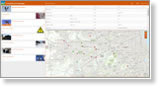
Get a sneak peek at one of the new Esri crowdsourcing app templates designed for engaging communities. View Crowdsource Reporter.
-
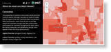
Which Americans like to watch horror movies, and which prefer comedies? Data from Esri will show you. Read the blog. View the Story Map Journal.

-
Esri offers Cutting Edge servers preinstalled with ArcGIS for Server on both Windows and Linux to bring the power of GIS to your organization. Order today.
The Last Word
-
ArcGIS Open Data now includes more than 22,415 open datasets from 1,600 organizations, including the City of Minneapolis, the State of Maryland, and the Environmental Protection Agency. Start exploring.
-
Students can use ArcGIS Online maps and data to investigate temperature extremes around the world. A lesson is included. Read the blog.