Tech Time
See eight great examples of the types of 3D web scenes of cities, buildings, coral reefs, and even bike routes that you can build using Esri technology. Read the blog.
-
Find out what you can do with Collector for ArcGIS and learn how to use the app to gather data in the field. Watch the one-hour technical session.
-
Learn to create and share compelling 3D maps and scenes using Esri technology. Get a sneak preview of the free ArcGIS Earth app too. Attend the September 24 live training seminar.
-
You asked for the new capabilities and enhancements, and Esri packed them into ArcGIS Pro 1.1. Read the blog.
Maps & More
-
Learn to make a map that routes four restaurant inspectors to 36 eating establishments in a day. The goal: Maximize their time at the restaurants and minimize their time on the road.
Take the Learn ArcGIS lesson.
-
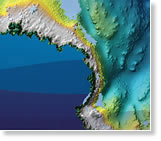
Help to shape the next generation of GIS tools for ocean science at the Esri Ocean GIS Forum, November 4-6, 2015. Learn the value of using GIS in fields such as ocean science research and fisheries management. Register to attend.

-
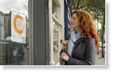
The new Trimble R1 GNSS receiver, offered by Esri, gives you the ability to collect highly accurate location data with your iOS or Android device running Collector for ArcGIS. Order today.
The Last Word
-
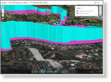
Ten years after Hurricane Katrina displaced more than one million New Orleans area residents, these Esri maps show the neighborhoods that were flooded, the population shifts, and the areas restored.
Read the article on Smithsonian.com.
-
From collecting data about damaged trees in Washington, DC, to broken light poles in Sweden, there are countless ways to use Collector for ArcGIS. Read the article.