Tech Time
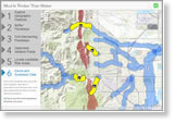
Use real Boulder County, Colorado, spatial and demographic data in ArcGIS Online to identify areas at highest risk for flooding and landslides. Mud Is Thicker Than Water is a new project at Esri's Learn ArcGIS website. Start working on this project today.
-
The ArcGIS Pro prerelease is available. Use Pro to build projects; visualize, analyze, and manage your data; and share your work.
Read more and download ArcGIS Pro.
Watch the video.
-
The ArcGIS Online update includes a web application builder (in beta), new analysis tools, and the ArcGIS Open Data app. Try the GeoForm application template for form-based feature editing. Read the blog.
-
Deciding what kind of GIS content to share and how to share it can be a challenge. Three tips will help you craft a content-sharing strategy for your ArcGIS Online organization. Read the tip.
Maps & More

-
Shot down over Germany during World War II, Royal Air Force navigator/air observer James Douglas Skinner parachuted to safety. But that's when his real troubles began. View the Story Map Journal app.
-
Wilderness conservation maps are on display at the Smithsonian Institution National Museum of Natural History in honor of the 1964 Wilderness Act. Read the article.

-
Documentation has been updated for the latest release of Data Appliance for ArcGIS, a solution that provides similar ArcGIS Online basemap content behind your firewall. Learn more.
Order Data Appliance for ArcGIS.
The Last Word
-
John Henry Cartwright left Australia to fight in the Gallipoli campaign in World War I. Maps, film clips, photos, historical documents, and text bring the history of the battle and one man's role in it to life. View the Story Map Journal app.
-
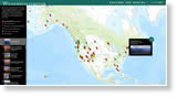
Compare today's maps of cities like Dallas, El Paso, and Austin with those from the 1800s and early 1900s using the Esri ArcGIS powered Texas Hidden History map viewer. View the historic maps.