Tech Time

Familiarize yourself with the various sections of the Esri Story Map Cascade app, such as the cover, sequential and immersive sections, titles, and credits. Find out what type of choices you will face when creating one of these apps. Learn more.
-
You can use ArcGIS Pro to view 2D and 3D representations of your data simultaneously by docking map and scene views side by side.
Read the blog.
-
Follow these steps to prepare your data for use in Esri CityEngine, the software that gives you the ability to create a 3D model of a real city. Read the blog.
-
David Cardella, Esri's product manager for developer technologies, answers 10 questions from developers about developing apps using the ArcGIS platform. Watch the video.
Maps & More
-
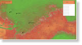
Use ArcGIS Pro to create your own 3D scene and animation of naturalist Alexander von Humboldt's expedition to South America in the late 1700s and early 1800s. Take the Learn ArcGIS lesson. See a finished version of the animation.
-
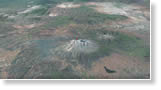
Explore the craters and volcanoes of Mars and see what the Red Planet would look like if water flowed there using the interactive (Is There) Life on Mars? web map. Go to Mars.
-
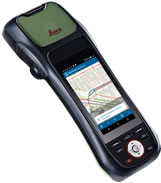
Combined with the latest release of Esri's Collector for ArcGIS, ZenoCollector from Leica is an all-in-one, high-accuracy data collection solution. Order today.
The Last Word
-
Thanks to contributors, the large-scale map layers in Esri's online basemaps keep growing and improving. You can find building footprints, railway lines, trees, neighborhoods, points of interest, and more, for places such as Aurora, Colorado; Pulaski County, Arkansas; Moorhead, Minnesota; and Ohio State University. View the maps in an Esri Story Map Journal.
-
Esri education manager Joseph Kerski offers five handy tips on how to make working in ArcGIS Online very easy. One of his recommendations is to name data layers descriptively. Read Kerski's blog.