Spring 2010
Spring 2010 |
|||||||
|
|
|||||||
Building INSPIRE: The Spatial Data Infrastructure for Europe |
|||||||||
|
By Max Craglia, Joint Research Centre of the European Commission
This, of course, is a rather simplistic perspective. SDIs are children of the Internet, without which they would not exist. They are also the response to an increased recognition that the environmental and social phenomena we are called to understand and govern are very complex, and that no single organization has the know-how and the data to do the job alone. Hence, we need to share knowledge and data across multiple organizations in both public and private sectors, and SDIs support this effort. INSPIRE
The key decision-making bodies are, therefore, the national governments—represented in the Council with a number of votes proportional to the size of the country—and the European Parliament that is elected by universal suffrage every five years. The European Commission is the civil service body of the EU and has the power of proposing legislation (to the Council and European Parliament) and monitoring its implementation once approved. Not being a federal state also means that there is no equivalent to the U.S. federal agencies in respect to the collection of topographic or demographic data like the United States Geological Survey and the Bureau of the Census. All data comes via the responsible organizations in the Member States. As a result, setting up an EU-wide SDI can only be done in a decentralized way, building on the SDIs and related activities established and maintained by the Member States. The purpose of INSPIRE is to support environmental policy and overcome major barriers still affecting the availability and accessibility of relevant data. These barriers include
The key elements of the INSPIRE Directive to overcome these barriers include
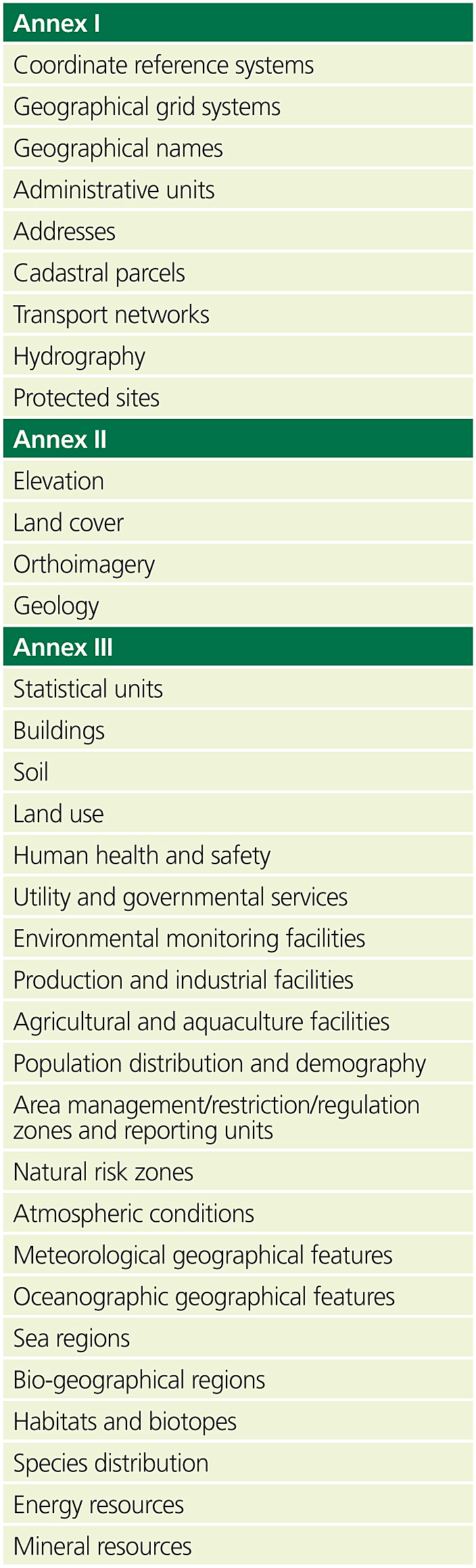
INSPIRE addresses 34 key spatial data themes organized in three groups (or Annexes to the Directive) reflecting different levels of harmonization expected and a staged phasing (see table 1). The legal framework of INSPIRE has two main levels. At the first, there is the INSPIRE Directive itself, which sets the objectives to be achieved and asks the Member States to pass their own national legislation establishing their SDIs. This mechanism of European plus national legislation allows each country to define its own way to achieve the objectives agreed upon, taking into account its own institutional characteristics and history of development. As an example, Germany does not have a single SDI but a coordinated framework with 17 SDIs, one for each of its states (L�nder) and one at the federal level (which also means that 17 different legal acts had to be passed to implement INSPIRE). Similarly, Belgium will have probably three SDIs, one for each of its regions (Wallonia and Flanders) and one for Brussels. The INSPIRE Directive also requires the establishment of an EU geoportal operated by the European Commission to which the infrastructures of the Member States have to connect. The drawback of having 27 different "flavours" of INSPIRE is that making the system work is undoubtedly more difficult. For this reason, the Directive envisages a second level of legislation, more stringent because it has to be implemented as is and does not require follow-up national legislation. In European terminology, this is called a regulation. Therefore, INSPIRE envisages technical implementing rules in the form of regulations for metadata, harmonization of spatial data and services, network services, data and service sharing policies, and monitoring and reporting indicators to evaluate the extent of the Directive's implementation and to assess its impact. Each of these regulations needs the approval of the Member States and the European Parliament. As of January 2010, the regulations for metadata, network services (discovery and view), and monitoring and reporting have already been approved. Those for data- and service-sharing policy, network services (transformation and download), and the first set of specifications for the harmonization of data have been approved by the representatives of the Member States and are now under the scrutiny of the European Parliament. INSPIRE has some characteristics that make it particularly challenging. The most obvious is that it is an infrastructure built by 27 different countries using more than 23 languages. The requirements for multilingual services and interoperability among very different information systems and professional and cultural practices are, therefore, very demanding. This means, for example, that existing standards have to be tested in real distributed and multilingual settings. In the best scenario, all works well, but for a European-wide implementation, there is a need to translate the standards and related guidelines into the relevant languages (International Organization for Standardization [ISO]; Open Geospatial Consortium, Inc. [OGC]; and other relevant standards are typically in English only). In other instances, testing has demonstrated that the standards are not mature enough, or leave too much room for different interpretations, and thus require further definition or individual bridges to make different systems interoperate. This can be seen with tests on distributed queries in catalogues all using the same specifications (OGC Catalog Service for the Web 2.0). The tests identified a number of shortcomings that required the development of an adaptor for each catalogue, which in a European-wide system with thousands of catalogues would obviously not scale. These shortcomings have been put forward to the OGC for consideration (for further details, see inspire.jrc.ec.europa.eu/reports/DistributedCatalogueServices_Report.pdf). In harder cases still, there are no standards available, and, therefore, they have to be created. This applies, for example, to "invoke" services that are needed for service chaining and to the specifications required for the interoperability of spatial datasets and services, which is a central feature of INSPIRE. To understand the context, it is worth reminding readers that each country in Europe has its own heritage and traditions, which include different ways and methods for collecting environmental and geographic data and different traditions on how to analyze and visualize the data, including different coordinate reference systems (sometimes more than one in each country), projections, and vertical reference systems. These different traditions mean that it is not enough for an SDI in Europe to help users find and access data. It is also necessary to understand the meaning of what we are accessing to make appropriate use of it. This means, in turn, that we need to develop not only translation tools to help overcome the language barriers but also agree on reference frameworks, classification systems and ontologies, data models, and schemas for each of the data themes shown in table 1 against which the national data can be transformed or mapped. This is necessary because we cannot ask the Member States and their national and local organizations to reengineer all their databases. Thus, the approach adopted is to develop agreed-upon European models and systems of transformation (on the fly or batch) so that the level of interoperability necessary for key European applications can be achieved. The approach sounds simple, but putting it into practice is very complex, as it has already required three years of work to develop an agreed-upon methodology (the Generic Conceptual Model) and tools; mobilize hundreds of experts in different domains; and deliver and test the first round of specifications for the Annex I data themes, with Annexes II and III to follow in the coming years. A visit to the INSPIRE Web site (inspire.jrc.ec.europa.eu/index.cfm) in the data specifications sections demonstrates the huge amount of work involved. The Organizational ModelThe organizational model put in place to develop INSPIRE is one of its more interesting features, drawing significant attention from outside Europe. In essence, it is a huge exercise in public participation, the like of which is most unusual in policy making, at least in Europe. From the outset, it was recognized that for INSPIRE to be successful and overcome the barriers to data access and use identified earlier, it was necessary for the legislators, implementers, and practitioners in the Member States to come together and agree on a shared understanding of the problem and possible solutions. Therefore, an expert group with official representatives from all the Member States was established at the beginning of the process in 2001, together with working groups of experts in the fields of environmental policy and geographic information to formulate options and forge consensus. The INSPIRE proposal was subject to an extended impact assessment
(inspire.jrc.ec.europa.eu/reports/fds_report.pdf and inspire.jrc.ec.europa.eu/reports/ inspire_extended_impact_assessment.pdf) to identify potential costs and benefits before opening for public consultation. The revised proposal was then debated by the Council and European Parliament over a To organize this process, two mechanisms have been put in place: the first is to engage the organizations at European national and subnational levels that already have a formal legal mandate for the coordination, production, or use of geographic and environmental information (called Legally Mandated Organizations, or LMOs). The second mechanism aims to facilitate the self-organization of stakeholders, including spatial data providers and users from both the public and private sectors, in Spatial Data Interest Communities (SDICs) by region, societal sector, and thematic issue. The central roles that SDICs play in the development of implementing rules include the following:
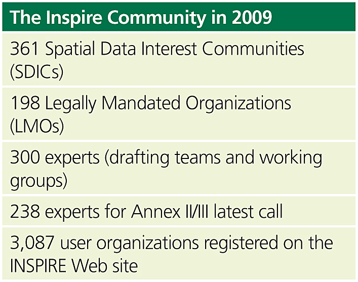
LMOs have similar functions but also play a central role in reviewing and testing the draft implementing rules and in assessing their potential impacts in respect to both costs and benefits. An open call was launched on March 11, 2005, for the registration of interest by SDICs and LMOs that were also asked to put forward experts and reference material to support the preparation of the implementing rules. The response was immediately very good, with more than 200 SDICs and LMOs registering within a month, putting forward some 180 experts (funded by them) from which we have set up drafting teams to help in developing the first batch of technical documents. At the present time, a second call for experts is open on the INSPIRE Web site to support the development of Annex II and III specifications, and an Internet forum (inspire-forum.jrc.ec.europa.eu) has also been set up for Member States to share experiences and tools to help implement INSPIRE. Table 2 shows the extent of the community directly involved in shaping the policy and the technical documents.
Three aspects are particularity important in understanding the work and the challenges of the drafting teams: first, each expert represents a community of interest and, therefore, has the responsibility to bring to the table the expertise, expectations, and concerns of this community; secondly, each drafting team has to reach out to all thematic communities that are addressed by INSPIRE. As a matter of comparison, it is worth recalling that the U.S. NSDI defined only seven framework themes: geodetic control, orthoimagery, elevation, transportation, hydrography, governmental units, and cadastral information, most of which have a federal agency that is taking the lead in data collection and management. The implication for the drafting teams is that they have a much more difficult task in collecting and summarizing reference material, seeking common denominators and reference models, and developing recommendations that satisfy user requirements without imposing an undue burden on those organizations that have day-to-day responsibility for data collection and management across Europe. Seeking compromise between different requirements and perspectives is crucial to the work of each drafting team. Last, but not least, it is important to note that the drafting teams have ownership of their work. They make the recommendations and submit them for review to all the registered SDICs and LMOs and the representatives of the Member States. It is only after they have taken on board all the comments received that the Commission takes ownership of the draft implementing rules and submits them for internal consultation. After revision and checking, the draft implementing rules go through the final round of the democratic process before becoming a new legal act. This involves qualified majority voting by the representatives of the Member States and the scrutiny of the European Parliament. The complexity of this participatory approach is certainly innovative not only in relation to the developments of SDIs but also more generally to the formulation of public policy at the European level. The outcome produces both consensus-based policy and the development and maintenance of a network of stakeholders that make it possible to implement more effectively this distributed European SDI. The ChallengesAlthough a great deal of work has clearly taken place with the support of many stakeholders, there are still several organizational and technical challenges (and opportunities) that need to be addressed. Organizational: The most immediate challenge is to maintain the momentum and the high level of commitment of all stakeholders and the experts contributing to the development of the implementing rules. This is not trivial and requires a notable amount of resources (time, money, expertise, commitment) to ensure that stakeholders feel ownership of the process, which then becomes a prerequisite for more effective implementation. Just to give an example of the scale of the task, the development of the data specifications for Annex I themes involved addressing more than 7,500 comments received from hundreds of stakeholders and organizing some 350 meetings (both physical and virtual) over a two-year period. If you consider that there were 8 themes in Annex I and another 26 to do, in addition to the revisions and maintenance of all guidance documents already created, then you have a sense of this facet of the organizational challenge. The INSPIRE forum is one way to address this challenge, but managing expectations, ensuring real participation, and delivering the benefits are key aspects we constantly need to focus on. Another facet, which is even more important, is the organizational challenge in the Member States to implement INSPIRE. The INSPIRE Directive asks Member States to establish and maintain their SDIs, nominate an organization as a contact point with the Commission, and set up appropriate coordinating mechanisms, all of which have given rise to a flurry of activity across Europe. In many countries, SDIs already exist and work well at national and subnational levels. So the effort is more focused on agreeing on a division of responsibility than in setting up new structures. In other countries, INSPIRE offers an opportunity for the organizations that have been leading SDI developments for years to get their just recognition and acquire new status and legitimacy. Of course, the difficult financial climate of this period makes it potentially more challenging to invest in new infrastructures and ways of working. Hence, the challenges in most countries are to leverage resources available from different sources (European, national, international) and/or ensure strong synergy between the investment required by INSPIRE and those committed in related projects, for example, in the framework of e-government. In this sense, the work needed is critical not only to align sources of funding but also to ensure that initiatives, standards, systems, and deployments are well coordinated and that they do not duplicate, or contradict, each other. Readers of this article who are familiar with large public-sector organizations will know how challenging this may prove to be. Underpinning this organizational challenge are the key issues of awareness, education, and training. Although we have involved thousands of people in the development of INSPIRE, and most national-level organizations in the Member States are aware of this initiative, there is still much to do. Even in the organizations involved in INSPIRE, sometimes only a few people are actively participating, and the level of awareness of INSPIRE and its future impacts may be lost to other parts of the same organization. Moreover, many public-sector administrations at the subnational level still have limited or no knowledge of INSPIRE. This is partly due to (1) insufficient dissemination efforts in the Member States; (2) local and regional authorities only becoming more directly involved when the data themes they are responsible for, which are mainly in Annexes II and III, are addressed by INSPIRE; and (3) the complexity of the technical documentation being produced at the present time, which very few people can understand or use. This brings us to the education and training issues. Even if we take a very simplified view of an SDI and assume that all it involves is creating metadata and setting up OGC-compliant services for discovery, view, and access, then where are the technicians versed in the relevant standards and technologies who will be able to implement these services across hundreds of datasets in the thousands of organizations across Europe? Who is training them? Where are the technical colleges and universities forming such competent technical staff? Where is the training material consistently being designed and translated across Europe so that everybody implements exactly the same specifications? And, where are the courses to train professional users (city planners, environmental engineers, social scientists, etc.) on the added value of the SDI to their work? The answer, of course, is that we still have to build up this capacity. There have been notable efforts in respect to the professional users such as the Center for Spatially Integrated Social Science in the United States (www.csiss.org) and several EU-funded projects in Europe (e.g., www.vesta-gis.eu), but the demand far outstrips the supply, and often, the funding to support these projects is limited to a few years, typically three or four. An interesting effort to overcome this short-term funding problem is represented by the Vespucci Initiative for the Advancement of Geographic Information (GI) Science (www.vespucci.org), a not-for-profit, self-funded initiative bringing together leading GI scientists and practitioners in intensive weeklong courses to foster interaction and exchange of experience along the "training the trainers" formula. After eight years of operation, some 500 participants have lived the Vespucci experience, and thousands more will have benefited from the indirect effects of being trained by the Vespucci alumni. Technical: The main challenge here is to develop and maintain an infrastructure that works and that delivers added value. As indicated earlier, the suite of international standards and specifications available is sometimes not mature enough to deliver or is subject to different interpretations, change, and inconsistencies. To give one small example, at the core of SDIs is metadata. The international standards for metadata for datasets and services are ISO 19115 and ISO 19119, respectively. The application schema for both is ISO 19139, but these schemas can be found at two different locations: the ISO repository for official standards and the Open Geospatial Consortium Schema Repository. Unfortunately, the schemas available at these two sites differ because of the different versions of Geography Markup Language (GML) they use. This is now being addressed, but it is just one example of the many problems one has to face in practice. The devil is always in the details, and in the case of INSPIRE, we took the view that it was not feasible to include all the very detailed specifications down to rules for encoding into a legal act, as any change in standards, technologies, or good practice would then require lengthy procedures to amend the legislation. As a result, the INSPIRE implementing rules are short and only say what functionalities are required, leaving the detailed implementation to nonbinding guidelines documents. This has its drawbacks, as we cannot guarantee that everyone will use the guidelines and that interoperability will be achieved immediately. On the other hand, experience has shown that we are still making small adjustments to the guidelines for metadata two years after their approval. Had they been set in tablets of stone (i.e., legally binding), there is no way that we could be able to make any change fast enough. So, in practice, we adopted a more pragmatic approach, setting up an Initial Operating Capability Task Force with representatives from the agencies in charge in every country to implement INSPIRE. With them we can discuss in detail how they are implementing their services, what seems to work, and what does not; make the necessary changes and adjustments; and disseminate good practice, as well as share tools (and reduce costs). INSPIRE is a process, not just an artifact! A second challenge is to facilitate the transition from a spatial data infrastructure perspective, that is, the "extended GIS metaphor" used in the introduction, which only addresses relatively few technical experts, toward a spatial information infrastructure, a service providing information products and analyses that are of wider use to nonexperts. This requires turning many of the functionalities and analytic processes encoded in GIS software and usable by few trained geospatial professionals into geoprocessing services that can operate in established workflows over the datasets available on the Web and provide answers to questions posed by the many who are not experts. The research issues here are many and include eliciting and formalizing processes and models from experts; turning them into geoprocesses, which can be understood and used across disciplines (including explanation of the theoretical underpinning of models so that they can be used appropriately); and selecting the appropriate service to go with the appropriate data to contribute to addressing a question in ways that are methodologically robust. Some of these challenges were addressed, for example, by the ORCHESTRA project (www.eu-orchestra.org/overview.shtml), but in that instance, all the geoservices had to be chained manually, which would not scale up in a global setting with thousands of datasets and services available. So we need automatic or semiautomatic means of making the right choices and links. To add spice to these challenges, there are also always new ideas and technologies to understand and harness. So as we were settling in to implement service-oriented architectures (SOA) for SDIs with the corollary of ISO metadata, OGC discovery services, etc. (i.e., following the paradigm of the library that separates the resources from their metadata), along came Linked Data (linkeddata.org) with Resource Description Framework (RDF) to provide semantically rich descriptions of resources and their linkages. Of course, Linked Data and SOA are not necessarily at odds. However, this is a good example of the way one needs to build the infrastructure for today with a view to where we should be going tomorrow. Toward the Next-Generation Digital EarthTo help sharpen our vision of the future, the Vespucci Initiative brought together in 2008 a number of environmental and geographic information scientists from academia, government, and the private sector to consider the changes that have taken place since the 1998 Digital Earth speech by U.S. Vice President Al Gore (www.isde5.org/al_gore_speech.htm). The meeting was an opportunity to consider the major technological developments that have made it possible to bring the experience of Digital Earth to hundreds of millions of people in their homes and desktops. It also reviewed the many public-sector-led initiatives aimed at organizing geographic information (SDIs and INSPIRE, the Global Earth Observation System of Systems initiative [earthobservations.org], the International Society for Digital Earth [www.digitalearth-isde.org], etc.) and the major private-sector developments aimed at organizing world information geographically. These have made it possible for citizens to contribute and share geographic information easily and interact with each other in what is labeled as Web 2.0.
Overall, the emerging view was that there is a need to bring together these seemingly parallel worlds: top-down official information and bottom-up citizen-provided information. On this basis, we articulated a revised vision of Digital Earth to help guide our effort. This vision recognizes the need to integrate scientific and public- and private-sector data to help us understand the complex interactions between natural, man-made, and social environments over time and across space—a framework to help us realize what has changed or is likely to happen, when, and why. To support this vision, we also identified key research topics on which to focus our energies, including improved methods for the spatiotemporal modeling of heterogeneous and dynamic data (citizen provided, sensors, official), the visualization of abstract concepts in space (e.g., risk, vulnerability, perceived quality of life), and ways to assess and model reliability and trust in information coming from many different sources (for more details, see ijsdir.jrc.ec.europa.eu/index.php/ijsdir/article/view/119/99). You could argue that with all the work we still have to do to develop and implement INSPIRE in Europe, we can ill afford to look for new organizational and technical challenges and research topics. Yet we should never lose sight of why we are building these infrastructures and investing significant public resources to do so. They are not ends in themselves but a means to improve our understanding and stewardship of the environment and develop our knowledge-based society. Without a clear view of where we want to go and what is needed to get there, we will not be able to guide the process effectively and address the grand challenges of today and tomorrow. The Next-Generation Digital Earth paper provides an initial contribution in shaping the longer-term view, and we welcome your feedback and contributions on inspire-forum.jrc.ec.europa.eu/pg/groups/ 98/next-generation-digital-earth. About the AuthorMax Craglia works in the Spatial Data Infrastructures Unit of the Joint Research Centre of the European Commission. This unit is responsible for the technical coordination of INSPIRE, working closely with other Commission colleagues in the Directorate General for the Environment and EUROSTAT. Craglia edits the International Journal of Spatial Data Infrastructures Research (ijsdir.jrc.ec.europa.eu) and is one of the founders of the Vespucci Initiative for the Advancement of Geographic Information Science (www.vespucci.org). More InformationFor more information, contact Max Craglia, senior scientist, Joint Research Centre of the European Commission (e-mail: massimo.craglia@jrc.ec.europa.eu). |
 This article is about the European spatial data infrastructure (SDI), which is called, formally, Infrastructure for Spatial Information in Europe, or INSPIRE. Many readers of ArcNews will be familiar with the concept of an SDI, as efforts in the United States to develop a National SDI (NSDI) have been under way since the mid-1990s (see also "