Project Atlas Promotes Transparency and Progress for Puget Sound Restoration
Highlights
- The GIS-based Project Atlas helps the Puget Sound Partnership monitor restoration projects.
- In an easy-to-use map interface, the atlas summarizes projects monitored by the partnership.
- The ArcGIS suite of products was central to the development of the Project Atlas' unique dashboard display.
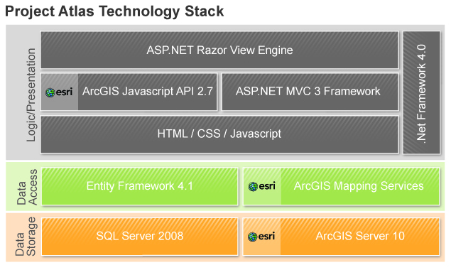
Esri products were integral to the data storage, data access, and logic/presentation layers of the Project Atlas solution. (Courtesy of GeoEngineers.)
The waters of Puget Sound extend more than 100 miles inland from the Pacific Ocean and make up a waterway and regional ecosystem central to business and recreation in Washington State. However, more than a century of industrial use—compounded by population growth and development—has resulted in increased pollution that threatens the region's economic vitality, human health, and quality of life.
In response to this growing environmental crisis, the Washington State legislature created the Puget Sound Partnership, a state agency dedicated to identifying, prioritizing, and coordinating efforts to protect and restore Puget Sound. Since its founding in 2007, the partnership has collaborated with state and federal agencies, local governments, tribes, businesses, and citizen groups to achieve specific cleanup and restoration goals for Puget Sound.
"We're responsible for bringing the more than 600 partners together, designing a unified plan, and making sure money is being spent efficiently, and our region is making progress," says Gerry O'Keefe, executive director of the Puget Sound Partnership.
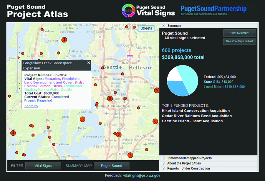
This street map view of Puget Sound displays all 21 Vital Signs. The user has selected one of the map markers to get more details for the Longfellow Creek Greenspace Expansion project. (Courtesy of Puget Sound Partnership.)
The partnership's accountability mandate requires it to keep elected officials, agency leaders, stakeholders, and the general public informed about where and how much progress is being made toward restoring Puget Sound. Although the partnership had access to several years' worth of project and financial data about several hundred projects across Puget Sound from partner organizations, there was no easy way to consolidate, view, or interpret that data to report progress.
Charting a Course Toward Greater Accountability
To solve its challenge, the partnership engaged Esri Partner GeoEngineers Inc. of Seattle, Washington, with funding through the US Environmental Protection Agency (EPA), to develop the Project Atlas, a web-based GIS performance accountability application with a dashboard interface that could display specific project locations, project details, progress toward completion, and related project costs.
The partnership also asked the company to collaborate with the technical team at the Recreation and Conservation Office (RCO), which shares IT resources with the partnership and is responsible for the project information presented in Project Atlas. Together, they would utilize the existing server infrastructure; collaborate and leverage development efforts of both teams; and host the application on the RCO infrastructure, which encompasses development, testing, and production environments.
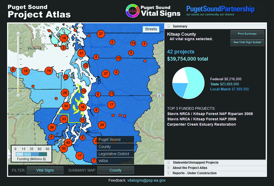
This view shows all of the projects in Kitsap County, outlined in yellow. When the user selects a different county, legislative district, or Water Resource Inventory Area, the data will be re-summarized. This dynamic clustering feature of ArcGIS for Server enhances the drawing speed of the Project Atlas and makes it scalable as new projects are added. (Courtesy of Puget Sound Partnership.)
RCO was already leveraging ArcGIS to store and share spatial information as part of its primary business processes, so GeoEngineers proposed to develop a solution that would take further advantage of the existing Esri technology. The company partnered with Rudeen & Associates of Boise, Idaho, whose intimate familiarity with RCO's PRISM database, its data, and existing infrastructure helped streamline the project timeline.
Joanne Markert, project manager and group leader of Implementation Services, GeoEngineers, explains, "Incorporating GIS allowed us to use RCO's project data in its native format without having to do any data conversion—a big time-saver on a project that would normally take four to five months. And we avoided adding a new technology for the IT staff to manage. Because the data connections were direct links, we knew data maintenance was not an issue."
The Project Atlas Solution Creates and Displays Puget Sound Maps with Meaning
The partnership had previously identified a list of specific measures, called Vital Signs, to serve as indicators of Puget Sound's health. These indicators were the basis for organizing tracked data in the Project Atlas, the custom application the team developed to help the partnership tell the story of Puget Sound's restoration.
The agency specified that users be able to filter geographic data points by Vital Signs and other nongeographic factors and then summarize and display a filtered subset of data points on a map. In other words, as a user selected each new geographic area—a county, legislative district, etc.—the data points would have to be resummarized.

Mt. Baker presides over this view of Puget Sound. Many area residents commute by ferry between Puget Sound's islands and urban hubs. (Photo credit: Montztermash.)
This dynamic filtering requirement indicated to the development team that a simple query approach would not be sufficient. GeoEngineers addressed the challenge in the Project Atlas by using ArcGIS for Server to manage the geographic data and serve that data to the web application and then, using ArcGIS API for JavaScript, allow the user to manipulate the geographic data. ArcGIS, combined with other technologies, enabled the Project Atlas to collect and process user selections, perform a complex query, and return the required data, displaying it in a map interface.
To speed the decision-making process, the company chose the flexible Agile project management framework to guide the project. The team's interface designer created mockups of reports and user interfaces, and the team presented them to the partnership for consideration. Throughout the project, GeoEngineers stayed in constant communication with David Jennings, the partnership's CIO, who served as the agency project manager for this effort.
Toward a Cleaner Puget Sound
The Project Atlas was launched in February 2012. The application successfully aggregates the large volume of project data and presents funding data in attractive map views. Its intuitive, easy-to-use filtering tools offer users in-depth views of state, federal, and local projects funded throughout Puget Sound. An enhanced second version is scheduled for release mid-2012.

Restoring Puget Sound's ecosystem helps species like this tiger rockfish and fish-eating anemone. (Photo credit: David Jennings.)
The Project Atlas currently includes over 600 projects that were financed, in part, by state-funded grants administered or tracked by RCO as of October 2005 or later. The combined funding total for these projects is $368 million. In addition, the application is extensible and built to handle future inclusion of new data sources, such as project data from EPA and the National Oceanic and Atmospheric Administration.
Alana Knaster, director of performance management for the partnership, comments, "The Vital Signs link in the Project Atlas will enable performance management staff to report more comprehensively on all the efforts in Puget Sound that are targeted toward specific resources. Information in the atlas, paired with monitoring data on ecosystem indicators, will support decisions on our progress in meeting 2020 recovery targets."
Summing up the Project Atlas's success for the Puget Sound Partnership, Jennings remarks, "It's all about accountability. We have an obligation to let folks know what we are collectively doing to restore the health of Puget Sound: showing what, where, by whom, and the associated costs. And this tool helps us do just that, in an easy-to-understand way. Project Atlas and the work of the partnership represent the transparency people expect from government."
For more information, visit Project Atlas; contact David Jennings, chief information officer, Puget Sound Partnership (e-mail: david.jennings@psp.wa.gov); visit the Puget Sound Partnership website; contact Joanne Markert, Implementation Services, GeoEngineers (e-mail: jmarkert@geoengineers.com); or visit GeoEngineers.com.