ArcUser Online
Place and Health
Designing communities that promote well-being
By Monica Pratt, ArcUser Editor

This article as a PDF.
"GIS is moving to a different stage," Esri president Jack Dangermond said in his keynote address at the Healthy Communities by Design Summit held in November 2010. "We now want to create better communities from the start, not just fix communities that we have messed up. We need energy and thought about the kind of communities we want to live in." (See the accompanying article, "Summit Promotes GeoDesign for Healthy Communities.")
Researchers in health care, along with planning and environmental management, were early adopters of GIS. In health care, GIS has underpinned much of the work that has been done to understand and respond to pandemics and other types of disease outbreaks, optimize emergency health care response to natural and human-caused disasters, and manage hospitals and health care facilities more effectively.
As GIS has moved to the enterprise level in many organizations and expanded to new platforms (e.g., Web, mobile, cloud), public health officials and researchers began implementing an approach to promoting well-being called healthy communities. More preemptive, less reactive, this approach exploits new GIS capabilites and applications of GIS and a methodology called GeoDesign.
What Are Healthy Communities?
The idea behind healthy communities is not new. It was expressed in 1979 in the U.S. Department of Health and Human Services' Healthy People Initiative. It is a deceptively simple idea: "Increase the quality of life for all Americans and eliminate disparities in health status."
Health is more than the absence of disease and infirmity—it is well-being. Healthy Community Design, a program of the Centers for Disease Control and Prevention (CDC), stresses the importance of community design to increase physical activity and access to healthy food; decrease or minimize injuries, mental health stresses, and the effects of climate change; and improve air and water quality and the strength of social connections.
The CDC, World Health Organization (WHO), and other organizations that promote health advocate designing new or redesigning existing communities in ways that

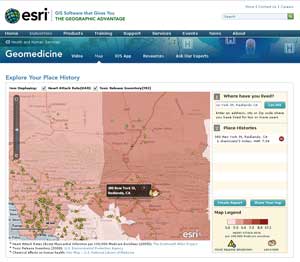
My Place History, a free, simple-to-use app developed by Esri for the iPhone, iPad, and iPod Touch, demonstrates how GIS can provide insights into the effects of personal geography on individual health.
- Integrate different kinds of housing choices with access to government and commercial uses.
- Promote transportation alternatives to driving such as bicycling, walking, and using mass transit.
- Preserve open spaces such as parks, forests, and wildlife corridors.
- Encourage brownfields cleanup and development and the practice of infilling sites rather than continually developing at urban boundaries.
The places where you live (and have lived) affect how healthy you are and how likely you are to die in any given year. The Grim Reaper's Road Map: An Atlas of Mortality, published in Britain in 2008, is a collection of maps that reveal the geographic patterns of mortality for specific causes of death. For example, people living in southern Scotland are more likely to die from brain cancer, while those in northern England are more likely to succumb to cervical cancer.
In his TED talk, Esri's health and human services industry manager Bill Davenhall asked, "Can geographic information make you happy?" After suffering a heart attack in 2001, he examined the places that he had lived and discovered that—quite unintentionally—he had lived in some of the most polluted places in the United States. "By design, if I'd wanted to have a heart attack, I've been in the right places," he said. Relevant information on the quality of the air, water, ground, food, and other factors about the places where Davenhall lived was never considered in his medical treatment at any stage of his life.
However, this is easily accomplished using GIS. Esri has created My Place History, a free, simple-to-use app for the iPhone, iPad, and iPod touch that demonstrates how GIS can provide insights into the effects of personal geography on individual health. Nations spend great sums of money collecting data on areas with adverse environmental conditions. In the United States, much of the data about these environmental conditions is readily available. After inputting the addresses and time periods where the user has lived, My Place History queries data from the Dartmouth Atlas of Health Care, the Toxic Release Inventory of the United States Environmental Protection Agency, and the Haz-Map of the U.S. National Library of Medicine to identify potentially adverse conditions near each address and creates a personal place history for an individual.
Just as GIS can be used to assess the factors that could have contributed to Davenhall's heart attack, its ability to place data and information in context to discover relationships is a powerful tool for moving from diagnosis to prevention and from the individual to the community.
Unintended but Not Inconsequential Consequences
Poorly designed communities can significantly contribute to poor health outcomes for their residents. The tremendous impact of community design can be appreciated by looking at the causes and effects of obesity, just one aspect of health that is linked to design.
Many problems plaguing communities, like obesity, have been quite literally built into them. The classic 1950s vision of suburban development separated where people worked from where they lived and where they shopped. As Dangermond has observed, this type of development is the product of "cheap energy and single-sector thinking. We can do much better by looking beyond economic considerations into social, environmental, and other factors."
Separating where people live from where they work means hours spent commuting. This really means hours of sitting, often in congested traffic, while driving to and fro, which adds to the stress of a long day.

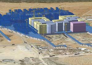
The geodatabase made data about the Masdar City project available as maps, data, and analytic services via ArcGIS Server to the more than 100 organizations involved.
In highly auto-dependent communities, stores, schools, and other common destinations, as well as employment centers, can't be reached except by car. These communities typically lack an infrastructure that promotes exercise and often have limited ready access to fresh, healthy food choices. Consequently, they also have many individuals who are overweight and obese.
Many chronic, life-threatening diseases—diabetes mellitus (Type 2 diabetes), cardiovascular disease, stroke, hypertension, and some cancers—are associated with obesity. Taken together, these diseases impose a great economic burden on health care systems and contribute to morbidity, mortality, and disability and detract from the quality of life for afflicted persons and their families.
Diabetes, just one of these lifestyle-related diseases, exacts a staggering price from society. The American Diabetes Association estimated that in 2007, diabetes in the United States cost $174 billion. Diabetes treatment accounted for $1 in every $10 spent on health care. Other indirect costs of diabetes include absenteeism, reduced productivity, and lost productivity (caused by early death).
Making Problems Visual
The development of GIS-based tools for GeoDesign provides a way to significantly improve how communities are designed or redesigned to encourage lifestyles that help residents maintain a healthy weight.
What is GeoDesign? Michael Flaxman, assistant professor of urban technologies at the Massachusetts Institute of Technology, defined GeoDesign as "a design and planning method that tightly couples the creation of design proposals with impact simulations informed by geographic contexts." It is a methodology for balancing social and biological aspects with economic considerations when planning communities. With GIS, the hidden costs of decisions can be teased out and quickly assessed.
"One of the powers of GeoDesign is it makes these problems visual," said Thomas Fisher, dean of the College of Design at the University of Minnesota. He sees GeoDesign as a powerful approach because it makes problems visual. "They [problems] are easier to ignore when they are abstractions. Because we have been designing the world without data-rich knowledge of consequences, we've created a situation where we've made ourselves vulnerable as a species, which to me gives urgency to GeoDesign. This is something we don't have a lot of time to develop."
Suburban development in the United States over the past 60 years illustrates the unintended consequences of designing without "data-rich knowledge" and context. To meet the housing needs of veterans returning from World War II, a planning model was actively pursued that separated where people worked from where they lived and where they shopped. The argument for this type of suburban development was that the relatively low cost of housing (at least during the initial development phase) made it more affordable.
However, an important question wasn't asked: What does a daily commute really cost? According to the U.S. Census, getting to work means driving alone for 77 percent of American workers. The gasoline required for the trip is an obvious cost, but the expense of purchasing, maintaining, and insuring a car and the cost of building and maintaining the streets, highway, and freeways needed by all those suburban commuters should be included in the tally.

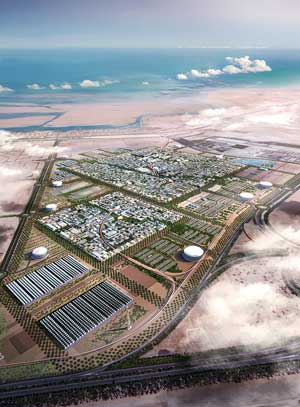
Masdar City will be the world's first carbon-neutral, zero-waste city powered by renewable energy sources.
Highway fatalities are a less obvious cost of commuting. In 2009, nearly 34,000 people died in auto and motorcycle accidents according to the National Highway Traffic Safety Administration. Air pollution, a factor strongly correlated with many potentially fatal conditions, such as asthma and heart disease, is also a by-product of commuting that affects not only commuters but anyone living in the region, especially those in proximity to freeways and highways.
Even less apparent is a cost in quality of life. Commuters strapped in car seats for hours each day, often stressed by traffic congestion, are deprived of time with family and friends and have more limited opportunities to exercise or follow other pursuits.
A more comprehensive accounting of the costs associated with the decision to separate work and home can be accomplished and the resulting information visualized with GeoDesign. Placed in a larger context, that house in suburbia no longer seems as affordable.
A New Kind of Community
GeoDesign is the process and GIS the technology that enable a quick and penetrating design. While this Imagine > Visualize > Assess > Repeat approach is not new, the technology to realize it more effectively is. Esri is evolving ArcGIS to provide platforms, tools, models, and workflows that can drill down into contextual information and also be rapidly iterative.
The vision of a community designed to be both healthy and sustainable is becoming a reality in the southeastern Arabian Peninsula. Located in Abu Dhabi in the United Arab Emirates (UAE), Masdar City is heralded as the world's first carbon-neutral, zero-waste city powered by renewable energy sources.
The information needed to design, build, and operate Masdar City is managed in GIS. CH2M HILL, an Esri business partner, was chosen as a leading partner on this project. CH2M HILL used GIS to integrate data on the geography of the area with a range of the design strategies of traditional Arabic architecture and regional urban planning practices with advanced renewable energy and clean technologies.
"Building a city like this has never been done before, and GIS is proving to be an absolutely critical tool," said Shannon McElvaney, who was an information solutions consultant for CH2M HILL on the project. (McElvaney is now the Esri GeoDesign project manager.) Information from the geodatabase containing data on environment, infrastructure, elevation, vegetation, imagery, buildings, costs, schedule, and carbon tracking was made available as maps, data, and analytic services via ArcGIS Server to the more than 100 organizations involved in the project.
The Time Has Come for Healthy Communities
Creating healthy communities is an old idea that has been reborn at a time when the tools are available to realize this goal. Historically, planning processes have cast social values and environmental values as competing with economic considerations. GeoDesign takes into account the impact of decisions. By quantifying the cost of adverse effects to society and the environment, these hidden economic impacts can be assessed. When considered in context, social, environmental, and economic factors are not in conflict but in harmony.
"We are on a threshold. Now we have the technology to change things," said Dangermond at the Healthy Communities by Design Summit. "We can bring this down to individual decisions and make those decisions consistent with sustainable practices. This process uses the Web, is inclusive, and uses the language of visualization. It will use a process that will let us look at alternatives and their consequences and evaluate them quickly to determine whether an action and its consequences are appropriate for sustainable communities."
Find out more about Geomedicine.