ArcUser
Summer 2012 Edition
iPad Application Aids Map-Based Crop Reporting
Insurer improves accuracy and communication
By Karen Richardson, Esri Writer
This article as a PDF.
Providing the right amount of crop insurance coverage to customers at a fair price is a balancing act. If too many acres are reported, the customer pays too high a premium. If too few acres are reported, coverage is inadequate in the event of a covered loss. To take the guesswork out of reporting acreage, Great American Insurance Group created an innovative ArcGIS-based reporting tool that is available on the iPad, and it's revolutionizing the business.
With corporate headquarters in Cincinnati, Ohio, Great American Insurance Group's Crop Insurance Division has 4,500 independent agents in the United States. It has been providing crop insurance to farmers for more than 100 years. The company is engaged primarily in property and casualty insurance, focusing on specialty commercial products for businesses. The insurance underwriting process requires that agents visit each farmer and complete an acreage report. Ultimately, that report is reconciled with acreage records at the Farm Service Agency (FSA), a department of the United States Department of Agriculture (USDA).
Depending on the type of crop planted, the time to submit these acreage reports can be limited, so efficiency is critical. During this reporting window, agents work with clients to determine accurate acreage for the crops that have been planted and, in certain circumstances, acreage that has not been planted. Insurance coverage is based on this report, so it must be complete and accurate. If the acreage FSA has on file for a farmer and the acreage reported by the agent don't match, coverage could be jeopardized.
Several years ago, USDA—through FSA—began moving the farming industry toward map-based reporting to improve accuracy. USDA mapped farmland in the United States and created the Common Land Unit (CLU) as a standardized GIS data layer in shapefile format. This layer, which includes all farm fields, rangeland, and pastureland in the United States, supports farm service programs including insurance. Having this data repository allows FSA to track crops, gather important data for trend analysis, and assist in determining whether fraud has occurred.
From Complicated to Easy
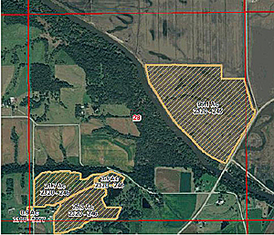
Six years ago, Great American's Crop Insurance Division started to use mapping software to communicate more effectively with its agents, policyholders, and the USDA. Great American implemented ArcGIS in its IT departments. It can download FSA CLU shapefiles into its system for use by agents when creating reports with clients.

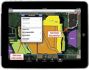
GreatAg gives agents access to acreage and crop information. Agents can edit attributes such as type of crop and plantiang date and perform basic editing on field boundaries.
Because FSA and Great American use the same standard format, information can be passed between them without additional preparation. This saves effort and improves accuracy. Now data is not lost transferring it from a paper form or from files in a different mapping format. "We are able to agree on what is planted in the field and roll this data up into our own systems right away," said Dale Perry, divisional assistant vice president of marketing for the Crop Insurance Division at Great American.
Initially, Great American provided data to agents as an ArcGIS for Desktop application. This was challenging for agents. They were not familiar with mapping programs and could not access the data when visiting clients' sites. Maintaining databases for individual agents was a strain on the IT staff. "This was a complicated workflow for everyone involved," said Perry. "While we were one step closer to providing a great experience for both our agents and their clients, we knew we could do better."
Bringing Efficiency to the Workflow
Great American's IT department worked with Esri Professional Services to incorporate its workflow into a web-based, hand-held solution that was fully integrated with the reporting system; had no extra logins; and, as Perry explained, "just worked."
The application, called GreatAg for iPad, was developed using the ArcGIS Runtime SDK for iOS. ArcGIS for Server capabilities, such as powerful mapping and geoprocessing, are now available embedded in maps in this line-of-business application, which connects Great American's team, agents, and customers. "The most important thing we got right was understanding that our agents are salespeople, not IT folks," said Perry. "We provided them with a solid web-based application that was very user-friendly."
The GreatAg application can be downloaded from the Apple iTunes store. All data, except for maps, is downloaded and stored locally on the agent's iPad so it can be accessed without an Internet connection. Agents have access to all the information about their clients' Multiple Peril Crop Insurance policies and claims. This is important because agents work in rural areas that often have limited Internet access. Agents can access policy documents and obtain electronic signatures from clients without worrying about finding an Internet connection.
If an agent has Internet access, the GreatAg application also provides access to acreage and crop mapping information. Agents access maps on their iPad from Great American servers and edit attributes associated with CLU shapefiles, including type of crop, farm name, and planting date, and perform basic editing on field boundaries such as splitting and combining fields. New fields can also be created directly from the CLU layer using freehand drawing. Once information is collected and both parties agree, policy forms can be uploaded with digital signatures for processing.
Extensive security controls ensure that personal information is properly safeguarded. "All this information is shared with the corporate database, so the same data is available in the traditional policy and claims web applications, as well," said Perry.
By keeping GreatAg for iPad simple and efficient, Great American has created a "win-win-win" solution for agents, policyholders, and the company. They have also created a companion marketing tool that can be used in the field. "Nothing speaks louder than being able to provide the right service for a client with the convenience of mobile computing," said Perry.
For more information, contact Dale Perry at DPerry@gaic.com.
