Colorado City Implements Local Government Data Model
Model enhances geodatabase functionality while meeting business goals
By Steve Holmes, GIS Manager, City of Loveland, Colorado
The City of Loveland, Colorado, worked with Esri for several months on a new data model for maintaining GIS data in local governments. The need for a model arose from the city's desire to
 |
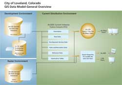
| In this model, feature datasets are based on "maintenance obligation." Annotation is not feature linked as these datasets existed prior to this functionality. The development instance is moved to the "current" instance nightly with a Python script. The HTE databases contain items such as building permit and utility billing information. The city is currently transitioning from ArcIMS to ArcGIS Server. |
utilize functionality offered within the geodatabase. Each city department has specific business objectives. Loveland wanted a comprehensive model that would support users in various city departments.
Since its inception 20 years ago, the city's GIS, the Loveland Geographic Information/Cartographic (LOGIC) System, has been successful. The system received two URISA Exemplary Systems in Government (ESIG) awards—the small municipality system category winner in 1998 and an honorable mention for enterprise systems in 2005. Loveland also received Esri's Special Achievement in GIS (SAG) Award in 2005 for its work in local government systems.
Data Model Objectives
Because the city had gone through two major data and platform migrations, staff members knew that changing the overall data structure would be an even more substantial undertaking and one that was not taken lightly. This project would require the migration of many more data layers and take longer to complete. The project's objectives had to justify these efforts.
The project's main objectives were to
- Accommodate newer enterprise solutions utilizing the geodatabase.
- Realign existing shapefile field structures into a common attribute schema.
- Consolidate common layers into fewer feature classes.
- Adopt a simple, standardized model that met the needs of a variety of users.
- Use a model based on a nationally recognized format that was expandable and incorporated templates that could be used for data layers that had yet to be developed.
A New Data Model for the New Geodatabase
In 2005, the City of Loveland began looking for a geodatabase model that would meet these objectives. Models were found that partially met the needs of the city. Others were very elaborate, but were tailored to the needs of individual organizations. For a while, it looked as if the city would need to create its own custom model.
However, in response to the annual preconference survey for the 2006 Esri International User Conference in San Diego, California, the city told Esri that it could enhance service to its local government clients by providing a comprehensive model and some new tools to help with the migration from legacy datasets into new geodatabase designs.
This led to Steve Gris�'s involvement in Loveland's project. Gris�, an Esri staff member who has been responsible for developing data models, contacted the GIS manager at the City of Loveland. The two met at the User Conference, and thus began an exchange of ideas about the model and geodatabase concepts.
At the beginning of 2007, the U.S. Geological Survey's (USGS) GIS for the Nation model came up for discussion. It met most of Loveland's objectives, but it would require modification to accommodate all of Loveland's data layers. Gris� analyzed current data and maps from a number of local government organizations, USGS, and other ArcGIS data model initiatives. Subsequent discussions on needed changes to the models were coordinated by Gris�.
These efforts resulted in a model template that was presented by Gris� at the 2007 Esri International User Conference. A new tool, called GDB Xray, was also developed by Gris� that allowed users to start with a geodatabase template and make revisions in Microsoft Excel. This tool reads revised Excel spreadsheets and creates a new geodatabase based on the changes.
GDB Xray and the new local government model template can both be downloaded from arcscripts.esri.com by searching on the word XRay. The model has integrated design and documentation tools to make the geodatabase more accessible.
Implementing the New Model
Loveland, using the new model and the ArcGIS Data Interoperability extension, prepared to deploy the new geodatabase to its users in early 2008. Loveland staff finished up some custom ArcObjects tools for ArcGIS that automatically relink data sources for the the city's 2,200 map documents (.mxd files). Loveland's next challenge will be working with the State of Colorado and federal agencies on developing methods that will ensure Loveland's data is available for use by other agencies in response to natural disasters or other emergencies.
Model Details
In addition to meeting the city's objectives, the new model employs some new concepts worth mentioning such as feature datasets based on data maintenance obligations and shapefile-style field names that better accommodate the transfer of data.
Loveland has also gone beyond the basic template and incorporated what could be considered feature-level metadata in its geodatabase. Each feature class in the city's managed data feature dataset has the following fields for each feature:
- A general feature description
- The data originator
- Data security status
- The distribution policy
- The last modified/creation date
Data from other sources is kept in the reference data feature database. This distinguishes data for which Loveland is the authoritative source and data from other sources.
To discuss details of the model and the GDB Xray tool, contact Steve Gris� at sgrise@esri.com.
To talk about Loveland's transition into the new model, contact Steve Holmes,
GIS manager, City of Loveland, Colorado, at holmes@ci.loveland.co.us.
About the Author
Steve Holmes, GIS manager for the City of Loveland, Colorado, has 15 years of professional GIS experience. He has also worked as a professional land surveyor in Colorado and New Jersey and a professional planner in New Jersey and is a certified GIS professional (GISP).
|