ArcGIS Explorer Brings GIS to Everyone
Esri's new ArcGIS Explorer goes where no virtual globe has gone before.
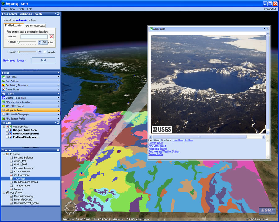 ArcGIS Explorer shown with the default basemap of global imagery and eco-regions in Oregon from a published ArcGIS Service. In addition, pushpins showing cascade volcanoes and including live links to USGS photos have been added by importing a text file. |
Powered by ArcGIS Online, and designed to be a delivery platform for ArcGIS Server, the no-cost, lightweight client opens a window to a rich world of geographic content and geographic information system (GIS) capabilities that takes users far beyond a simple 3D sightseeing tour of Earth.
Using ArcGIS Explorer, people can view maps and globes in 3D while conducting queries and analysis on underlying data.
The application comes with simple-to-use navigational tools that let people pan, tilt, identify, and zoom in and out on a set of 3D globes including a default globe of world satellite imagery. But the application's real tour de force springs from being able to access content and capabilities from various GIS services including geoprocessing capabilities from ArcGIS Server, giving people the ability to query and analyze data, fuse content, and produce maps and reports, which can then be published within their organizations or shared with the public on the Internet.
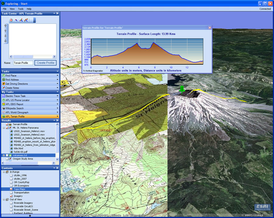 ArcGIS Explorer with ArcGIS Online imagery and topographic map services. A custom task has been used to generate the terrain profile. |
Like an artist working with a palette of colors, a user can dip into local data and online content services from a wide array of sources and create maps on ArcGIS Explorer globes. "The ArcGIS Online globes that are available for ArcGIS Explorer are considered the foundational elements upon which GIS users will put additional data," said Bern Szukalski, ArcGIS Explorer product manager at Esri. "It's the canvas upon which users will paint their own content."
ArcWatch recently sat down with Szukalski and asked him to explain in more detail the basics of ArcGIS Explorer, what functions the application performs, and how the product stands out from other virtual globes such as Google Earth.
Q. What does ArcGIS Explorer do?
A. The way we like to define it is "GIS for Everyone." That is its mission. It's meant as an easy way to deploy GIS capabilities to a broad audience, either within an organization or onto the Web. It's really a part of an overall GIS system that not only allows users to publish and offer ways to visualize GIS information but also provides a platform for delivering GIS analytic capabilities in an easy-to-use application.
Q. You've mentioned that ArcGIS Explorer uses ArcGIS Online services. Can you explain what that means?
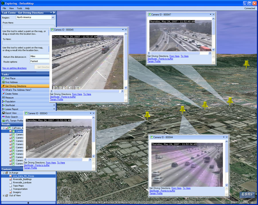 ArcGIS Explorer showing the locations and realtime feeds from California Department of Transportation (CalTrans) Traffic Web cams. |
A. ArcGIS Online is a new family of online services, joining our other desktop, server, and mobile families of products. ArcGIS Online provides Web-based content and capabilities for all Esri users, but it's an integral part of ArcGIS Explorer. For example, when you first start ArcGIS Explorer, you will see a globe of world imagery. That's being published through ArcGIS Online. When you open the ArcGIS Explorer Resource Center under the Help tab, you will see a variety of other globes you can open such as world streets and political globes. Those are published through ArcGIS Online. The Find Place task is powered by ArcGIS Online, too. So it's a collection of Esri-hosted online services, both content services and functional ones.
Q. But ArcGIS Online is available in other products, not just ArcGIS Explorer. Is that right?
A. Yes, that's right. If you're an ArcGIS Desktop user, that same content and many of the functions are also available to you when you're online. ArcGIS Online is meant to provide the foundation for GIS, whether you use ArcGIS Explorer or any other ArcGIS Desktop. And the ArcGIS Online content is available as ready-to-use 2D maps and layers as well as 3D globes for use in ArcGIS Explorer.
Q. What globes can ArcGIS Explorer users access from the Resource Center?
A. The ArcGIS Explorer Resource Center, which you can open directly from the application, includes a collection of ready-to-use globes for ArcGIS Explorer users. Currently, there are eight globes including world satellite imagery, political boundaries, streets, and shaded relief. The Resource Center also includes some featured maps like world protected areas and historical maps. The Resource Center will continue to be updated with more globes over time.
Q. Describe some of the basic functions users can perform using ArcGIS Explorer.
A. Included in ArcGIS Explorer are tasks such as Find Place, Find Address, and Get Driving Directions,. But users can also author their own tasks using ArcGIS Desktop, serve those using ArcGIS Server, then connect and use them with ArcGIS Explorer. So this means that I could author a model or build some geoprocessing function that I can publish and use with ArcGIS Explorer. This is what makes ArcGIS Explorer unique-its ability to provide a platform for delivering a complete set of GIS functionality to users.
Q. How does ArcGIS Explorer perform these tasks and others?
A. By default, ArcGIS Explorer is connected to servers at Esri. Users can connect to their own services, but the initial configuration connects ArcGIS Explorer to Esri. ArcGIS Server provides the content and functional services for ArcGIS Explorer. ArcGIS Explorer is designed as a lightweight application for connecting to and communicating with ArcGIS Server and that's how it gets the content and functional capabilities.
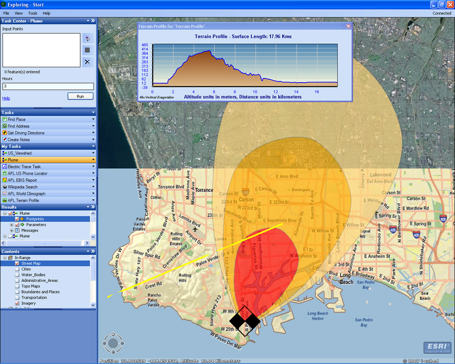 ArcGIS Explorer showing ArcGIS Online imagery and streets services and the results of GIS Tasks that have generated a terrain model and plume showing the spread of pollutants in the event of a fire. |
Q. What content is available? Can people also work with their own data?
A. Through ArcGIS Explorer, customers can access GIS services including those published through ArcGIS Online and any services published using ArcGIS Server. ArcGIS Explorer can also view ArcIMS, ArcWeb, and Web Map Services (WMS). ArcGIS Explorer also works with local data such as shapefiles, file geodatabases, KML, JPEG 2000, GeoTIFF, MrSID, IMG, and other image formats. For example, a city government can combine its own detailed maps with content from Esri and create a new map on an ArcGIS Explorer globe.
Q. How can users publish GIS capabilities online?
A. Users can publish their own content or tasks by using ArcGIS Server. The first step is to author the map, which is done using ArcGIS Desktop. Once the map document is saved, it can be served using ArcGIS Server, then ArcGIS Explorer and other applications can connect to and begin consuming the published services.
In a similar way, a user can author an analytic model using ModelBuilder, the geoprocessing framework found in ArcGIS Desktop, and publish those through ArcGIS Server as well. So whether it's maps or tasks the user wants to publish, the way that's done is to author the capabilities in ArcGIS Desktop then do the serving on ArcGIS Server 9.2.
Q. How does ArcGIS Explorer stand out from other virtual globes and how will GIS professionals benefit from the software?
A. ArcGIS Explorer was designed with ArcGIS Server in mind. It was designed as a way to visualize not only global imagery but other kinds of globes as well (such as worldwide streets, terrain, boundaries and labels, political maps, and physiography). It was also designed as a platform for adding your own content and tasks. Essentially, it was designed to be a way for GIS users to publish GIS capabilities to a wider audience. The big difference between ArcGIS Explorer and other virtual globes is that it can leverage all the higher-end GIS modeling, analytic, and geoprocessing capabilities that are inherent in ArcGIS Server. Those can be published to a broad audience using ArcGIS Explorer. People have gotten used to a paradigm of a globe, so we adapted some of those same paradigms because people expected it, they wanted it, and there was demand for it. It seemed easy for people to understand and use.
Q. Where can people find more information and download ArcGIS Explorer?
A. Visit www.esri.com/arcgisexplorer.
Q. How can users get started using ArcGIS Explorer?
A. Most users will start with the default globe of world imagery and high-resolution imagery for the United States. The default tasks can be used to explore that globe as well as the other globes published at the ArcGIS Explorer Resource Center. Users can also add their own content and begin making their own globes using ours as basemaps. The Getting Started topic in the Help tab is a good place to learn more, and we will also have an ArcGIS Explorer blog where ideas and tips will be shared. The Esri ArcGIS Explorer and ArcGIS Online Web sites will also offer resources for users to learn more.