While there are many standards organizations that cater to creating standards for the information technology community, the Open Geospatial Consortium, Inc. (OGC), and the International Organization for Standardization (ISO) Technical Committee 211 are the two leading geospatial standards organizations. Esri has had a long-standing commitment to standards and interoperability in the geospatial realm. It has maintained a leadership role as a member of the OGC board of directors and the planning and technical committees and has been a participant in numerous test processes, pilot projects, and specification products published by OGC.
Common Geospatial Standards
There are many geospatial standards. They generally fall into one of three categories: data, metadata, and services.
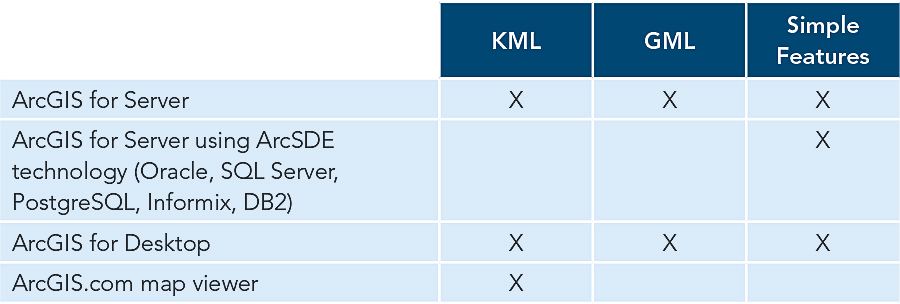
Data standards are used to store geospatial data in a common format or transfer data from system to system via extract, transform, and load (ETL) operations. Open geospatial data standards include KML, GML, OGC, and ISO Simple Features; and the shapefile.
Metadata standards are used to store, organize, manage, and share metadata for geospatial data. Open geospatial metadata standards include ISO Metadata Specifications, the Content Standard for Digital Geospatial Metadata—Federal Geographic Data Committee, OGC Catalog Service for the Web, and Z39.50 library catalog services.

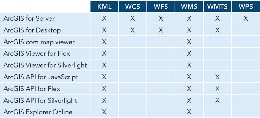
Services are standards used to transfer data over the web or provide remote access to data stored on a web server. These services allow users to interact with the data, usually through simple web clients, on a live, real-time basis. This includes viewing maps, accessing and querying data, running analyses, and downloading data. Open geospatial services standards from OGC include Web Map Service, Web Feature Service, Web Coverage Service, Web Map Tile Service, and Web processing service (WPS). Additionally, in 2010, Esri released the ArcGIS REST API (GeoServices REST) as an open specification under the Open Web Foundation. GeoServices REST services allow web clients to communicate with GIS services via the REST interface. Esri is working with other members of OGC to make the GeoServices REST an established OGC standard.
Esri’s Support for Standards
Esri has built the ArcGIS platform to support established standards from the ground up. The ArcGIS for Server architecture is an example of Esri’s core services-based geospatial platform to use established standards to meet users’ needs. ArcGIS for Server uses a RESTful pattern for its services—a pattern built on core HTTP roots. This makes the services simple to consume and increases the integration points available to connect ArcGIS with customer relationship management, business intelligence, and other enterprise-level systems. ArcGIS also supports non-RESTful geospatial standards to provide alternate integration points for interacting with other systems using geospatial standards from OGC or ISO. This design framework helps move the industry forward by leveraging new and improved workflows while making sure that standards-based interoperability considerations are effectively leveraged and maintained.

Developing New Standards
Standard development is a very long process that includes multiple working groups and technical committees. This can lead to long delays between the development of a standard and its industry-wide adoption. These delays lead to “sync issues,” where the establishment of a standard fails to keep pace with the development of new technology. Also, standards—geospatial standards in particular—often have multiple released versions that many vendors support at differing levels. Esri strives to support the latest versions of established standards for the optimal level of interoperability.
Esri does not focus only on established and mature standards but also participates in OGC test beds and other venues for standards development. The WPS specification from OGC is still in development, but with ArcGIS for Server now supporting it at 10.1, Esri is pushing the envelope on building ArcGIS client technologies that support this standard. Esri is open to similar collaborative initiatives to not only keep current with latest technology trends but also build for the needs of tomorrow.
To view resources related to this article, visit esri.com/StandardsPapers.
See also “Transforming ArcGIS into a Platform.”

