GIS Hero

A veteran of more than 15 years in Utah’s state government, Bert Granberg remains enthusiastic about public service. “Working in state government is rewarding to me because the scale of it, especially in a state the size of Utah, makes it possible to build meaningful and productive connections horizontally and vertically.”
Granberg is currently the director of the Utah Automated Geographic Reference Center (AGRC), a position he has held since September 2012. Originally, the Columbia, Missouri, native was not headed for a career in either public service or GIS. He received a bachelor’s degree in political science from Carleton College in Northfield, Minnesota, where he specialized in technology and public policy.
After receiving that degree, he moved to Utah to take a break before going on to graduate school. He was captivated by the state and “its place-based amenities including southern Utah’s spectacular red rock landscape, the alpine ski terrain perched just above Salt Lake City, and of course all the trails, parks, and wild lands that are easy reachable on weekends.”
Although Granberg didn’t want to leave Utah, he still wanted to go to graduate school. A master’s level certificate in urban planning offered by the geography department at University of Utah seemed aligned with his interests. However, once at the university, Harvey Miller, one of the department’s professors, convinced Granberg to pursue a degree in GIS instead. He did, and in 2000 he received a master’s degree in GIS.
While completing that degree, he worked as a GIS programmer/analyst at the University of Utah DIGIT Lab, becoming its interim director upon his graduation. Granberg then left the university to join AGRC, where he became the manager of the State Geographic Information Database (SGID) for the next 11 years.
AGRC is a division of the Utah Department of Technology Services (DTS). It has about a dozen full-time staff members who work on application development, facilitate local and state GIS coordination, operate a GPS base station network, and—most important—maintain SGID. It has a hybrid business model. Part of its budget comes from general funds, and part is generated by offering desired services through interagency agreements and grant programs.
Established in 1984 by Utah’s farsighted lawmakers, based on a belief that location and spatial relationships are of fundamental value in serving the state, AGRC has been working to eliminate information silos in government for more than 30 years. With SGID, AGRC has created and carefully curates one of the most outstanding repositories of geographic information in the nation. This one-stop resource for Utah’s geoinformation is free and accessed by users worldwide. In addition to agency contributions, AGRC has partnered with agencies and institutions across the state and the nation. Participation by all state agencies in populating SGID was codified into state law in 1991.

AGRC, an early adopter of Esri technology, was among Esri’s first 100 customers. Granberg, too, has been using Esri products for a long time, starting in graduate school when the software was just transitioning from command line-based ARC/INFO to GUI-based ArcView GIS. Thanks to his ARC/INFO experience, Granberg received a solid grounding in command line, digitizing, and pen-plotters. He is also thankful for “the view under the hood of GIS design that I got from learning and using Avenue and later ArcObjects.” Both gave him a fundamental understanding of the technology.
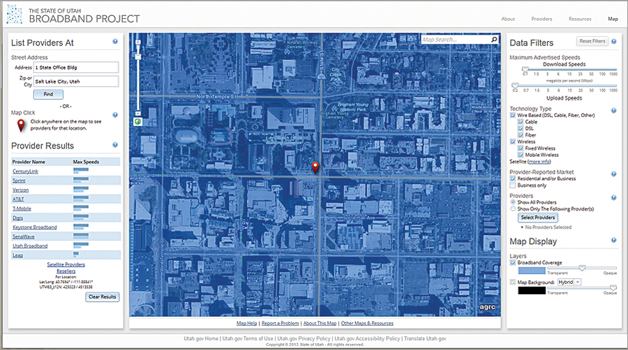
That understanding of GIS has helped him see opportunities for expanding the technology across the enterprise. Of the many projects he has been involved in while at AGRC, Granberg is very pleased with the benefits accrued from projects that leverage the connectivity of the web. The clearinghouse websites at gis.utah.gov have been successful in providing access to data as well as news and software tips. AGRC’s web services, the geocoding API, basemap services, and spatial query API at api.mapserv.utah.gov “leverage Esri technology but allow others to benefit without having a specific technology stack or knowing the details and formality of GIS web services,” Granberg noted.
Another project he points to is the implementation of a GIS foundation for the assignment of new precincts and districts to registered voter records. “I think this was a first at the state level.” AGRC also has collaborative funding partnerships for high resolution aerial photography and lidar. A current project to realize operational efficiency increase goals set by Governor Gary Herbert employs GIS as part of agency strategies. “This is just getting started but the interest from executive management is really encouraging.”
When asked about his role in AGRC’s success, Granberg is characteristically self-effacing. “The real story has little to do with me, but rather is what decision makers, managers, and GIS professionals, past and present have been able to build in Utah,” said Granberg. “Where we’ve had success as a state, it is almost always, fundamentally, a team effort that sources its strength from the dedication individuals pay to their agency mission, but while occasionally keeping an eye open for the enterprisewide value that can be gained through sharing data and building products and services that impact a broader audience.”
“To the extent that I am associated with Utah’s success, I really have to credit the folks who laid the foundation, including my predecessor Dennis Goreham and the perennial leaders of the Utah Geographic Information Council, including Kevin Sato, Nick Kryger, Dave Henrie, and Don Wood who also represent the commitment to GIS made across city and county government in Utah,” noted Granberg.
Throughout his career, he has been actively supporting more intelligent use of geospatial information on state and national levels. He is currently a member of the National Geospatial Advisory Committee and has been a board member of the National States Geographic Information Council (NSGIC) for more than five years. He is also a former member of the Utah Geographic Information Council. Interaction with peers has been beneficial to him and his organization.
“I also greatly value the opportunity to participate with colleagues from other states who are active with NSGIC,” said Granberg. “Almost every idea that we consider implementing at AGRC has benefited in some way—new ideas, feedback on ideas, strategy, coordination advice, etc.—from the peer-to-peer networking that NSGIC facilitates.”
Information gathered through participating in the larger GIS community has helped Granberg enhance AGRC’s ability to serve its ultimate customer: the business of government and the people and organizations that it serves.

