Web Maps Steer Senior Citizens to Cool Zones During Summer

The extensive interactive mapping platform offered by Salt Lake County, Utah, lets users find anything—from township services and county council representatives to historic temples and community gardens.
But the Salt Lake County Cool Zones map, launched in July 2015 for Salt Lake County (SLCo) Aging and Adult Services, might also save lives.
Locating Close Cool Zones
Summers in Salt Lake County can be roasting. Temperatures often soar above 100 degrees Fahrenheit during the day, causing some people to wilt when they venture outdoors.
Excessive heat can be extremely dangerous to senior citizens and disabled persons—especially those whose houses or apartments lack air conditioning. To reduce the instances of heat-related illnesses, such as heat exhaustion and heat stroke, SLCo Aging and Adult Services launched the Cool Zone Program to open air-conditioned libraries, senior centers, recreation centers, and indoor ice skating facilities (called ice centers) to senior citizens and people with disabilities. There are currently more than 30 Cool Zones in Salt Lake County.
To help people find the Cool Zones closest to their homes, the SLCo Aging and Adult Services agency asked the Salt Lake County Surveyor’s Office to create a user-friendly, interactive map of Cool Zone locations.

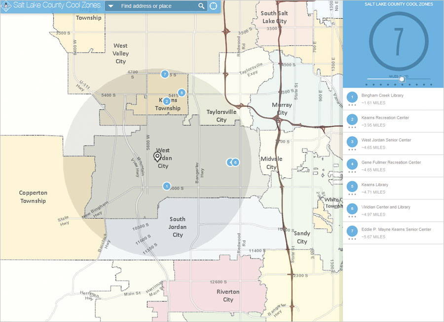
The Surveyor’s Office decided to use the Local Perspective configurable app, available in ArcGIS Online, to create the web mapping app. The Local Perspective template—one of dozens of configurable apps that Esri offers in ArcGIS Online—gives users the ability to find the mapped Cool Zones closest to them by either placing a point on the map to mark where they live or typing their street address into a search box. The app then displays the Cool Zones within a buffered distance of the location the user selects.
For example, if the user enters an address on Hollywood Avenue in Salt Lake City and chooses a three-mile radius around that location, six Cool Zones will appear as pop-ups on the map as well as in a list along the right side of the page. The app was configured to create a one- to ten-mile radius around a point on the map.
When the user selects one of the Cool Zones—for instance, Fairmount Aquatic Center near Hollywood Avenue—the distance from the user’s location will appear (e.g., 0.94 miles), along with the facility’s address, telephone number, hours of operation, and other pertinent information such as the current local temperature.
Residents of Salt Lake County can find the Cool Zone interactive map on the Cool Zone Program section of the SLCo Aging and Adult Services’ website.
Building the App in Less Than a Day
Emily LaMunyon, a GIS analyst and web developer for the Salt Lake County Surveyor’s Office, created the map. She said it took less than a day to build the app.
First, she compiled a list (from a Microsoft Excel spreadsheet) of Cool Zone locations in the area into a GIS layer in ArcGIS for Desktop. The layer included all the important information associated with each place.
Next, she published the layer as a map service using ArcGIS for Server to make the map available on the Internet. She added the map service to ArcGIS Online so she could use it as the Cool Zones layer in the web map.
To complete it, LaMunyon added a custom basemap that SLCo GIS created and configured the pop-ups in the Cool Zones layer so users can see more information when they click on a Cool Zone location in the map. Finally, LaMunyon shared the map in ArcGIS Online using the Local Perspective app.
“This app was a perfect fit because it allows users to enter their address, use the Locate tool, or just simply click on the map and see which Cool Zones are closest to them,” said LaMunyon. “It was also simple to configure the text, colors, [and] logo and add current weather information.”
Guiding People to “Safe Havens”
Before GIS technology existed, the collaborative delivery and coordination of services—which have a direct impact on people’s lives—would have been inefficient, time consuming, or impossible, said Salt Lake County surveyor Reid J. Demman.
“The Cool Zone map is interactive, simple to use, and allows our at-risk population to locate safe havens from the summer heat,” he continued. “This is a great example of the practical application of GIS technology to a real-life human need.”
LaMunyon was happy to create the Cool Zone app.
“I like to think the work we do as GIS professionals has a positive impact on the daily lives of people,” she said. “I love it when projects come my way that allow my work to be of benefit to the citizens that we serve.”
Besides LaMunyon, contributors to this project included Izabela Miller, GIS analyst for Salt Lake County Information Services, and Alex Rudowski, GIS specialist for Salt Lake County Public Works Engineering and Flood Control.