Explore the Trail, Plan Recreational Activities, and Share Pictures Using a Mapping Application from Esri Canada
Online Exclusive

Canadians can use a new web mapping application to plan hikes, horseback rides, and other trips and post photos and stories of their adventures on the Trans Canada Trail (Trail).
Developed by Esri Canada Limited, the application at tctrail.ca/ maps a 16,800-kilometer network of interconnected trails. The Trans Canada Trail stretches from St. John’s, Newfoundland, west to Victoria, British Columbia, and north to Tuktoyaktuk, Northwest Territories. By the time Canada celebrates its 150th anniversary of confederation in 2017, the completed Trail—built by volunteers—will total 23,000 kilometers and link more than 1,000 communities. It will be the longest multiuse recreational trail in the world.
Today, four out of five Canadians live within 30 minutes of the Trans Canada Trail, and tens of thousands get out on the trail network to stay fit, see the wildlife, and visit historic sites and scenic areas. The online mapping application from Esri Canada contains interactive features that can help them plan runs, hikes, bike trips, horseback and snowmobile rides, and cross-country ski trips.

For example, users can create a route for an organized five-kilometer walk by placing pins on the points of the Trail where they want the walk to begin and end. In a pop-up window, they also can add the date, time, and a short description of the event. Alternatively, they can create a story about a trip they took on the Trail such as a snowmobile ride, upload their photos, and share the adventure with other users.
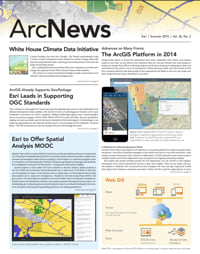
The application also lets people click on any segment of the Trail to get details such as its name; length in kilometers; and the recreational activities allowed such as hiking, cross-country skiing, horseback riding, and snowmobiling.
Interested in paddling a water trail? Check off canoeing from a list of activities, and only water trails will appear in yellow such as Path of the Paddle in Quetico Provincial Park in Ontario.
Esri Canada donated the app to honor its commitment as a member of Chapter 150, a circle of visionary and philanthropic business leaders that have joined forces to support the Trail’s development.
“Building the Trans Canada Trail is a significant achievement for Canada, and we’re proud to be part of this historic journey,” said Alex Miller, president, Esri Canada. “In the same way that the trail connects Canadians, our purpose for creating this web map is to give them a collaborative platform to connect through their trail experiences and help preserve our national heritage.”
Exploring the Great Outdoors, Virtually
By creating a free account, users can explore sections of the Trail to plan their next outing. The mapping application lets them select an activity such as horseback riding, canoeing, or snowmobiling; choose an environment such as urban, rural, or wilderness; and pick a surface such as paved, gravel, dirt, or water. Doing that brings up corresponding sections of the Trail.

Available in both French and English, the app provides detailed, historical information on featured trails across the country. For example, the Cowichan Valley Trail on Vancouver Island, British Columbia, crosses a 187-meter-long repurposed rail trestle that was originally built in 1920. As one of the largest timber bridges in the world, the trestle offers a spectacular recreational route for hikers, runners, cyclists, cross-country skiers, and horseback riders.
In Whitehorse, Yukon, the Whitehorse Copper Trail is the main line of the Trans Canada Trail, running through a copper belt last mined in the 1970s. The Trail connects many of the major multiuse trail areas in and around the city and provides a paved surface that’s ideal for walking, hiking, and cycling.
In Nova Scotia, the Salt Marsh Trail is part of an abandoned railroad that was transformed into part of the Trans Canada Trail. It provides an urban/rural adventure for hikers and cyclists alike and is especially popular with Nordic skiers in the winter. Paddlers can also be spotted during the warmer months.
“This online map makes the Trans Canada Trail accessible to Canadians and our many international visitors,” said Deborah Apps, president and chief executive officer, Trans Canada Trail. “Before venturing out, they can use the map to choose the best Trail section for the activity they have in mind. Or, if they are visiting a new part of the country, they can locate the section closest to them. The interactive aspect of the online map also lets Canadians share their experiences; our map is one more way that the Trans Canada Trail connects Canadians from coast to coast to coast.”

Robust Features, Intuitive Functionality
In addition to locating sections of the Trail by activity, environment, or surface, users can search by nearest address or section name. They also can find visitor centers and places to stay and view the local temperatures. They can also walk the Trail virtually and measure distances from point to point. Once they begin their journey, users can track their progress by inputting the number of steps or kilometers traveled. Maps can be bookmarked and printed out as PDFs. KML and GPX files of trail sections can also be downloaded.
Users can choose how they view the Trail by toggling between four basemaps. One of the basemaps was generated through the Community Map of Canada Program, which includes authoritative content from more than 100 federal, provincial, and municipal governments. Satellite imagery, a hybrid map, and a light gray canvas map are also available.
“The cartography used resembles real topography, which is very intuitive for hikers and outdoor enthusiasts,” said Matt English, technology lead, Esri Canada. “We wanted to create an app that was simple to use, attractive, and clean and would mimic the actual Trail as closely as possible.”

The app’s ability to integrate crowdsourced data lets users share photos and stories about their experiences on the Trail. Across Canada, users are documenting their bike rides, hikes, runs, and cross-country skiing adventures. For example, a group of senior citizens in Saskatchewan posted a story on the map, near the village of Macrorie, that said they had completed several weeks of walking the Trail, an “exciting and interesting” experience. A hiker in British Columbia reported that he had hiked up the lower part of the Trail from Caulfield, West Vancouver, and was planning a nine-kilometer hike to the Cypress ski area.
People have posted beautiful photographs on the map, including pictures of the world’s longest covered bridge in Hartland, New Brunswick, which stretches 391 meters (1,283 feet); a family of deer sloshing through a stream in Alberta; and paddlers on the South Saskatchewan River.
By integrating the mapping app with social media (such as Twitter, Facebook, and Flickr), hikers, Trail sponsors, and donors can submit comments and share photos of their experiences, which can then be accessed directly on the map.

The app was developed using ArcGIS for Desktop, ArcGIS for Server, and ArcGIS API for JavaScript. Esri Canada used ArcGIS for Desktop to create and maintain trail data in a geodatabase and then published the data to the web as a set of web services using ArcGIS for Server. The app consumes these services from Trans Canada Trail’s server in addition to basemap services from ArcGIS Online.
Since the Trans Canada Trail website launch in December 2011, nearly 5,500 users have created accounts to upload information to the map and use its various features. Esri Canada continues to collaborate with Trans Canada Trail staff on future enhancements for the app.
About the Trans Canada Trail
The Trans Canada Trail/sentier Transcanadien is a national nonprofit organization that supports the development and use of a national network of trails that links millions of Canadians from coast to coast to coast. Canadians and international visitors use the Trail to hike, cycle, ski, horseback ride, canoe, and snowmobile. Partnering with all levels of government, donors, and partners, the Trans Canada Trail supports the work of more than 400 local Trail organizations and thousands of volunteers across the country through Trail development grants and the promotion of their efforts to build and sustain one of the world’s longest and grandest recreational networks of trails. For more information, visit tctrail.ca.
For more information, contact Esri Canada at info@esri.ca.