How Ireland’s Roscommon County Council Publishes Open Data

Open data is quickly becoming an imperative for all government bodies in the Republic of Ireland. Indeed, it is a requirement for the Open Government Partnership (OGP), a global program launched in 2011 to promote government transparency around the world. To that end, in May 2014 the Irish government published its National Action Plan, which lays the foundation for how government organizations intend to share more information about their activities, increase civic participation, fight corruption, and use new technology to strengthen governance.
The plan helped Ireland become a full OGP member in July 2014. Now, all central government departments, public sector bodies, and local authorities are under even greater pressure to make more of their data open. In practice, this means giving any person or organization free access to vast quantities of public information, unconstrained by licensing agreements and available in standard formats used in a range of IT applications.
There are inevitable challenges to doing this—especially during a recession with staff, budgets, and time in short supply.
Roscommon County Council, the primary body of local government in Ireland’s ninth-largest county, serving 64,000 people, turned to GIS to surmount these challenges. In 2013, Roscommon purchased a license for the ArcGIS platform and discovered a ready-to-use template for publishing open data: ArcGIS Open Data.
The council’s GIS officer, Barry Doyle, used this ArcGIS Online template to develop a brand-new channel for delivering open data. As a subscription-based cloud service, ArcGIS Online requires no hardware infrastructure, no on-site data storage, and no system maintenance. So it was quick and inexpensive for Doyle to launch the new approach.
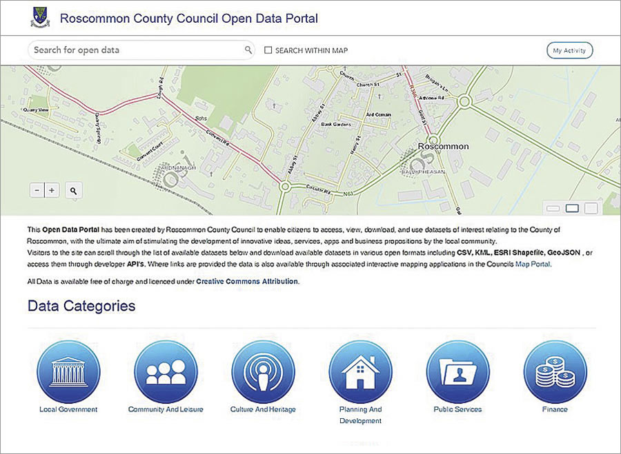
In less than two years, Roscommon County Council has published more than 50 datasets on its Open Data Portal that range from recycling facility locations and fishing sites to development plans and local election results.

Doyle is very impressed by how simple it is to publish datasets.
“ArcGIS Online makes it very easy for councils to create and maintain an Open Data portal,” he said. “You don’t have to be a programmer; you don’t have to export data in multiple formats; all the hard work is done for you.”
The Open Data Portal is an integrated part of the ArcGIS platform and, as such, draws on the same source of geospatial data as the public-facing interactive mapping applications the council has on its website.
“I only have to maintain and publish our data once,” said Doyle, “and it is presented to the public in two different ways.”
With ArcGIS Online, Roscommon County Council now has a simple means of publishing data in numerous standard formats, such as Microsoft Excel spreadsheets or Esri shapefiles, or via APIs—making it easy for anyone to access. This allows an array of organizations and individuals to support local businesses, sustain community groups, and stimulate the local economy using the council’s open data. What’s more, the council achieved its open data objectives cost-effectively, using minimal internal resources.
“If I hadn’t had ArcGIS Online,” explained Doyle, “I would have had to [engage] a web developer to build a separate website specifically for serving up open data. I would then have had to export all our data to the open formats, maintain it, and host it. That would have taken a lot of time and money.”
The Open Data Portal also saves Roscommon County Council time in retrieving and responding to requests for information. People can now go to the council’s Open Data Portal directly to find the information they need. Doyle estimates that he and his coworkers reclaim a week or two per year now that they don’t have to respond to so many information requests.
“I like to think that the benefits of open data will increase over time as more people catch on to the fact that all this data is available,” Doyle added. “As I publish more datasets, the more the value of our Open Data Portal will grow.”
As Esri Ireland’s Michael Byrne, a founding member of the Irish chapter of Open Knowledge, commented, “The achievements of Roscommon County Council clearly demonstrate Ireland’s readiness and ability to deliver on the open data agenda right now.”
For more information, email Roscommon County Council’s GIS manager, Barry Doyle.

