Texas is a broad, sweeping state—the second largest behind Alaska. Its geography ranges from bayous and beaches around Houston to rolling Hill Country and the desert landscape of Big Bend National Park in the west.
It was the Texas Hill Country near Austin that ignited a passion for the land in Sterling Harris. He grew up in a ranching family, then worked in the oil and gas industry after graduating from Sul Ross State University.
“I love taking care of the environment; there’s no doubt about it,” Harris says. “I’m a big proponent of responsible grazing and land management practices. This is what God has given you, and you want to take care of it.”

He began working in the GIS department of the Texas General Land Office (GLO) in the mid-1980s after a friend suggested it would be a good fit for him.
“He said, ‘Sterling, you’d fit in perfectly here. You love history, you love the land, and you love people—you’d fit in like a glove,'” explains Harris. “And thank goodness I came here. This is a great place.”
The Texas General Land Office was established in 1836 to manage the state’s first land records. It still protects more than 35 million historic land records, but now its primary functions also include earning money for the state’s Permanent School Fund (PSF) from sales and leases of public lands and safeguarding the state’s coast.
Texas is unique in the amount of public lands it owns. When Texas entered the union, the federal government would not allow the state to pay its debt with land. Texas owns more than 13 million acres of public lands, including submerged lands up to 10.3 miles offshore.
Guarding the Coast
To protect its coastline, the Texas State Legislature passed the Oil Spill Prevention Act in 1991. Funding from the legislation allowed the GLO to acquire GIS for contingency planning and response.
Once he became the GLO’s GIS manager in 1999, Harris took the leading role in managing data development for the agency’s oil spill toolkit. This toolkit was developed in partnership with the Coast Guard and includes environmental sensitivity maps, local knowledge guides, and area contingency guides for the Texas, Louisiana, Mississippi, and Alabama coasts.
First responders can use the atlas in the toolkit to see critical information, including where wildlife habitats are in relation to a spill.
“The oil spill toolkit has been such a success story over the years and is a real standard for emergency response for the natural disasters that have hit the Texas coastline,” Harris says.
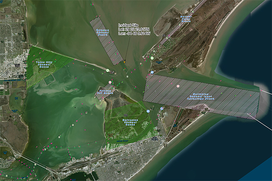
In March, responders used the toolkit to manage the spill in Galveston Bay after a barge carrying fuel oil collided with a cargo ship and began leaking more than 160,000 gallons of oil.
“I’m pleased that the hard work our GIS team has done over the years has made a difference in preparing and responding to major spills like this one,” Harris says of the incident.
Richard A. Wade, director, geographic information officer, Texas Natural Resources Information System (TNRIS), says, “Under [Harris’s] leadership, the Texas General Land Office has created one of the most successful GIS programs in the country. It continues to push the limits of technology for the development of highly successful GIS systems and applications. [Harris’s] innovative approaches to GIS development have been very inspiring to me personally.”
Managing Lands to Support Schools
The state of Texas uses revenue generated from sales and leases of public lands to contribute to the PSF. Interest earned on the fund, approximately $800 million per year, is distributed to every school district in Texas.

Soon after becoming the GIS manager, Harris started populating the Original Texas Land Survey (OTLS) data layer with Permanent School Fund Trust Lands attribute information. He created a public-private partnership with Tobin P2 Energy Resources to acquire the OTLS layer. For two and a half years, he and his team pulled all the records from the GLO file vault to verify each record showing mineral and surface interest for each tract in the PSF inventory.
The OTLS serves as the base layer on which all other GIS layers, including oil and gas leases, grazing leases, permits, and miscellaneous easements layers, are built.
“I can’t imagine not having GIS to maintain all that information, to not be able to see every active lease and well being drilled on leased land,” Harris says. “It helps us ensure that we are getting paid from those leases. GIS is the centerpoint of that now; it’s the front-end application for accessing all our lease information.”
Under Harris’s guidance, GLO also created the public-facing GISWEB Viewer, which includes OTLS boundaries, PSF lands, leases, oil and gas well locations, and imagery.
Making Life Easier
The underpinning of all Harris’s work with GIS has been a desire to make life easier for people—for the staff in GLO and the citizens that do business with the agency. Staff members, including those in Professional Services, Oil Spill Response, Surveying, Coastal Resource Management and Energy Resources, use GIS in their daily work.
“GIS helps them share information,” Harris says. “One person is looking up a lease on a property; the other is finding survey data. The interaction it creates among internal divisions is amazing. That’s what I see as a great asset for us—we are all looking at the same map and information through a GIS enterprise system.”
This is quite a change from the days Harris remembers when nobody knew what GIS stood for. Once he and his team began creating applications that staff could use, people were empowered with direct access to spatial information.
“Where I’ve seen the greatest achievement is getting people to use GIS every day in their work,” he says.
Maps and Apps
Giving the public access to the vast collection of spatial data in GLO is also a key function of the agency in Harris’s mind.
A wealth of downloadable GIS data is available on the GLO website, including leases, pipeline locations, and priority protection habitat areas. Oil and Gas Lease Sale Nominations data allows companies to see land that they can bid on.
In addition to the oil response toolkit and the GISWEB Viewer, Harris is behind online maps like the State of Texas Oil Spill Response Mapping Tool and Homeowner Opportunity Program (HOP) Area Locator. HOP is a disaster recovery housing program for those who live in Federal Emergency Management Agency-designated high-risk areas or areas of high minority and/or poverty concentration.
Harris’s enthusiasm for GIS has made him an early adopter of new technology. He is excited about how GLO is using ArcGIS Online and Collector for ArcGIS in the agency. In the works now are geographic response plans for specific waterways.
“I’ve seen the evolution from old paper maps to where we are today, and I can’t put a value on what it’s worth to us,” Harris notes. “It makes business better: people can see trends, where the hot areas are for leases, and the state of infrastructure; staff are more efficient in the field; and when people want to do business with us, they go through the GIS. It empowers people with the information and confidence they need to make decisions.”
Felicia Retiz, deputy GIO, TNRIS, says, “[Harris’s] passion for GIS takes him beyond the doors of the Texas General Land Office. He has been a permanent, contributing member to the Texas GIS community and is always among the first to be asked to participate on advisory committees and working groups. His opinion matters a great deal to his peers.”
For more information, contact Sterling Harris, GIS manager, Texas General Land Office.

