Lincoln, Nebraska, Uses GIS to Protect Citizens, Fight Crime and Fire
“Cops and fire fighters have been sticking pins in maps since there were cops and fire fighters,” says Tom K. Casady, director of public safety, Lincoln, Nebraska. “Today, however, GIS has essentially replaced the paper map. And mobile GIS takes information with the officer and fire fighter wherever they go.”
Indeed, Lincoln’s police—and now its fire, emergency medical services (EMS), and emergency management operations—are empowered with GIS analytics to effectively prepare for and respond to incidents. The city has extended its GIS benefits to the field using applications that run on smartphones and tablets. It helps staff understand any type of situation they are walking into as part of their daily work. It also enables two-way information exchange between managers in the office and personnel on the street.

“The early returns are very encouraging, and the feedback is almost universally positive,” says Casady.
Lincoln Police and Fire Service
The city of Lincoln, Nebraska, has a population of 262,000. Casady serves in the newly created position of public safety director. He is responsible for police, fire, EMS, and emergency communications. His background is in law enforcement; prior to being appointed as public safety director, he served as Lincoln’s chief of police for 17 years.
Casady has overseen powerful high-tech transitions at the city. From deploying geospatial analysis and visualization to fight crime to moving those capabilities to other public safety sectors, Casady has been at the forefront of keeping Lincoln Police well equipped with intelligent mapping technology. Back in the mid-1990s, Lincoln Police Department was an early adopter of GIS software.
“Crime analysts would then use GIS to reveal relationships that were concealed in the green-striped paper that rolled off those line printers,” says Casady. “We took advantage of GIS for three primary purposes: improving situational awareness, discovering and analyzing crime trends and patterns, and deploying resources more effectively.”
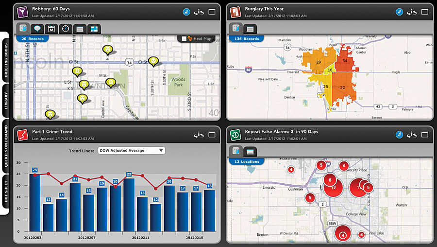
Today, following a focused hunt for the perfect solution, ArcGIS and the CrimeView suite of solutions from Esri Gold Tier Partner The Omega Group are at the core of Lincoln Police Department’s Crime Analysis Unit. Crime analysts work with incident and crime data; police dispatches; and arrest and accident reports; as well as with data on parolees, sex offenders, people with wants and warrants, and gang members. All these different data sources are then compiled and analyzed to generate bulletins and reports used by frontline officers and management staff and to feed interactive web mapping applications for both police employees and the public.
The law enforcement agency also uses GIS to propel crime prevention strategy. For instance, 25 percent of Lincoln’s residential burglaries occur through garage doors—many of which are left open or unlocked. GIS analysis revealed when and where these burglaries were most likely to occur. Armed with this information, at-risk areas were identified and targeted to find open garage doors and to alert residents.
“This strategy has been immensely successful in preventing this specific type of burglary, and this in turn has driven an overall reduction of residential burglary in Lincoln,” says Casady. “GIS helped to identify the most promising areas where this prevention effort would be most likely to yield results.”
GIS solutions have been extended to Lincoln Fire and Rescue Service. The agency makes extensive use of ArcGIS software for analyzing fire and medical calls for service, planning resource deployment, and navigation to an incident. Fire fighters also use GIS to access building preplans and stage operations for major incidents. Fire analysts use GIS to discover incident patterns, analyze alternative deployment strategies, study historical trends in service demand, and more.
For example, Lincoln Fire and Rescue deployed GIS to carry out a station relocation study for its 14 fire stations. In response to population growth, annexations, and increased calls for service, the agency needed to ensure that travel time to incidents would stay under four minutes, the mandated national benchmark standard. Using ArcGIS and Network Analyst, the agency looked at a variety of potential changes to fire station locations and the impact these moves would have on response times. GIS-based maps helped visualize information and make it actionable. Commanders could evaluate and answer critical questions, such as the following:
- Where are the areas of greatest service and areas of highest population density?
- What buildings are most susceptible to fire?
- What populations are most likely to suffer cardiac arrest?
They can then ask questions, such as these:
- What would happen to response times if some fire stations were relocated?
- What would happen to response times if the agency added fire stations?
- What would the new area of coverage be for each fire station if a new location was added?
In addition, maps created with ArcGIS for both fire and law enforcement are used in the department’s emergency communications center and integrated with the 911 telephone system for instant map display of incoming calls.
GIS Where and When You Need It
Mobile GIS has become increasingly important to both police officers and fire fighters. Approximately 15 years ago, the agency first began deploying mobile GIS by distributing Esri ArcGIS Explorer projects locally on mobile data computers in police cars and fire apparatus.
Today, web-based interactive maps are used. The emergence of broadband capabilities has made cloud GIS practical on mobile devices. Lincoln police officers and fire fighters have access to various Esri-based applications not only on mobile computers docked in their vehicles but on several types of handheld devices, including iPads, iPhones, Android smartphones, and Android tablets.
At the police department, officers use an innovative location-based services application, Proactive Police Patrol Information (P3i), that presents officers with a GPS-enabled map of points of interest in their immediate vicinity as they go about their work. Information that was previously accessible via desktop computer or mobile data terminal is now available on mobile devices in a mapping application that moves with the officer. Officers can view and access records related to calls for service, arrests, crimes, warrants, citations, parolees, probationers, gang members, and sex offenders. They can identify recent criminal activity, persons of interest, field interviews, and other information at or around a specific location. This supplies vital operational intelligence in the field for true situational awareness.
Instead of coming back to the vehicle or report room, officers can quickly look up information from wherever they are located. They can view a specific location’s 911 call history or an individual’s crime history. They can also view a map showing crime patterns for an area of interest. For example, a patrol officer can look at vehicle theft or home burglary in a neighborhood when responding to an individual incident to see if there is a possible crime trend that warrants more immediate attention or greater long-term strategic response.
The mobile GIS capability improves tactical crime prevention, response, and suppression. It also helps protect officers on the street by giving them detailed, accurate, and timely information. A similar technology is under development for Lincoln’s fire fighters and paramedics. The Fire and Rescue Department has created a GIS viewer linked to the department’s computer-aided dispatch records that allows a user to click an address from a dispatch record and immediately be launched into the GIS viewer. The user is automatically zoomed to the address of the dispatch and presented with a variety of critical information: basemap, aerial photos, ownership information, fire hydrant locations, and even detailed floor plans for high-risk facilities.
“The benefits of this type of mobile GIS work are numerous,” says Casady. “The net result is that we can perform at a higher level of excellence, and often with fewer resources than would otherwise be required.”
For more information, contact Tom K. Casady, director of public safety, City of Lincoln.

