Getting Real with Civic Engagement
ArcGIS Hub takes GIS to the next step by answering the question,
“What makes a community smart?”
As Andrew Turner, director of the Esri R&D Center in Washington, DC, emphasized in his presentation during the 2017 Esri User Conference Plenary Session, “Citizens want to be empowered to make informed decisions to improve their neighborhoods.”
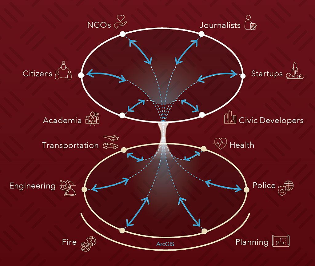
The answer is more than just open data. ArcGIS Hub is a new framework for transforming open data into actionable information that enables collaboration between government and communities through community initiatives. Its goal is to help governments make civic engagement structured, repeatable, and targeted toward prioritized issues to support data-driven work on policy initiatives and measure the outcomes obtained.

Currently, community engagement tools and data are often disconnected from government operational and decision support systems. This is not sustainable in the long run.
The hundreds of open data sites created by communities make it clear that citizens want more information on government. Since 2014, more than 8,000 organizations have started using ArcGIS Open Data, which lets anyone publish authoritative data using customized websites in a matter of minutes. This data is freely accessible by the public and easily explored using maps, charts, and tables. Data is downloadable in open formats and can be incorporated into apps built with developer APIs. Governments, universities, and other organizations have shared more than 70,000 datasets.
This open data movement, inspired by the desire for transparency in government and the need for innovation, created the foundation for ArcGIS Hub. Rather than a data repository, ArcGIS Hub is organized around policy initiatives that address community concerns and deliver data back to the public and across government in a way that is easy to consume, visualize, and analyze. Initiatives in ArcGIS Hub encapsulate a website, maps, apps, and reports that can be rolled out to the community. By bringing together data, visualization, analytics, and collaboration technology, ArcGIS Hub supports effective and open government that extends an organization’s GIS to support the entire community.
Engagement occurs more readily when people can join forces around issues and initiatives they care about. Examples of these issues and initiatives include reducing pedestrian deaths, fighting the opioid addiction crisis, and attracting businesses to the community. To enlist the whole community in addressing initiatives, ArcGIS Hub not only provides ways to inform citizens but also ways to listen to them by providing a mechanism for feedback and the ability to monitor progress using dashboards. They can follow initiatives, contribute crowdsourced data, and provide feedback. This creates an ongoing two-way dialog between government policy makers and the community that makes citizens more fully engaged.
ArcGIS Hub makes it easy for citizens to learn about initiatives and participate with a fully hosted, scalable community organization. This part of ArcGIS Hub scales independently from the rest of the associated ArcGIS system but is fully connected to it so information can be gathered and communicated. It manages this process through monitoring and tracking citizen engagement.
The structured framework enabled by ArcGIS Hub uses GIS data residing in departmental systems of record to inform policy initiatives. Data and analyses contributed by the broader community can improve operations and influence policy decisions. ArcGIS Hub brings together data, apps, narratives, events, key performance indicators, and engagement tools into initiative templates that address policy issues.
ArcGIS Hub comes with administrative tools for managing initiatives and a gallery of ready-to-use initiatives to make it easy to get started. Each initiative includes apps, maps, dashboards, and data already configured and comes with a complete toolset for creating initiatives that make an organization’s policies actionable—supported by websites, maps, apps, and content.
The next incremental step in the evolution of the ArcGIS platform, ArcGIS Hub creates digital public spaces that connect citizens to their government. It takes community engagement to the next stage by helping initiate fact-based conversations around specific themes. This is a powerful way to extend and amplify existing GIS investments. Esri president Jack Dangermond sees it as the new way forward for GIS. “I always thought it was going to be GIS for society. No, it is going to be quite practically done by organizations that want to engage around real stuff and make things happen.”
For more information, visit esri.com/hub.
