In 2008, the National Geodetic Survey (NGS) announced in its 10-year plan the replacement of the country’s two national datums: North American Datum of 1983 (NAD 83), the geometric datum used mainly for horizontal positions, and the North American Vertical Datum of 1988 (NAVD 88), the vertical datum used for determining orthometric heights (elevations).
The NGS, the United States federal agency that maintains the country’s National Spatial Reference System (NSRS), is part of the National Oceanic and Atmospheric Administration (NOAA). The NSRS is a coordinate system that is the foundation for all national geospatial products and is used for mapping and charting in a wide variety of science and engineering applications.
Datums Briefly Explained
To accurately measure the surface of the earth, surveyors have spent decades creating a complex network of brass disks embedded in the ground, known as reference points or benchmark monuments, and measuring the angles and distances between them. Horizontal benchmarks are determined by latitude and longitude, while vertical benchmarks traditionally represent the height of the reference point in relation to a datum surface (usually one that is close to mean sea level).
Relating those reference points into a group forms the fundamental dataset for a survey reference frame. Datums (created from such sets of data) are the basis for all geodetic survey work and indeed all types of surveying, mapping, and navigation.
A datum also can provide the basis for an abstract mathematical model of the earth known as an ellipsoid. It defines the relative definition of the size and shape of the ellipsoid and its orientation in space. Ideally, a universal datum that maintains the same level of accuracy throughout the world would be very beneficial. In reality, hundreds of different datums have been developed by individual countries that make use of their system of national reference points established over time. These datums are still in use today. This means that datums are usually most accurate in the country where they were created.
Mean sea level—which is used for the vertical benchmark measurements—is difficult to determine accurately due to coastal effects on tide gauge readings. In addition, mean sea level is not the same throughout the world because sea levels are affected by gravity, and gravitational pull is not uniform. Mountains, valleys, the varying densities of the earth’s composition, and groundwater levels, as well as other natural phenomena, such as earthquakes and floods, all affect gravity.
Unfortunately, due to the number of different datums in use, the same location can be referenced by different coordinates, depending on the particular datum used. For example, there is more than a 200-meter difference for some European locations between the European Datum 1950 (ED50) and World Geodetic System 1984 (WGS84).
This is due in part because ED50 is based on the Hayford, or International, ellipsoid, which is larger and of a different shape than the WGS84 ellipsoid on which the WGS84 datum is based. But the primary cause is that different survey data was used to position and orient the two ellipsoids with respect to the physical earth. To reduce these differences, there is a movement toward adoption of more uniform global datums. However, such changes will take time.
The Effect of Replacing Datums
Three NGS geodesists—Michael Dennis, Dana Caccamise, and Bill Stone—provide insight into how replacing the country’s two national datums—NAD 83 and NAVD 88—will impact the geospatial community.
“The accuracy of the measurements provided by the Global Navigation Satellite System (GNSS) is our primary reason for implementing new reference frames and a new geopotential datum that are consistent with GNSS measurements,” said Dennis. This increased accuracy is achieved in part because the GNSS satellites orbit around the earth’s center of mass, and the origin of the new reference frames will correspond with that geocenter.
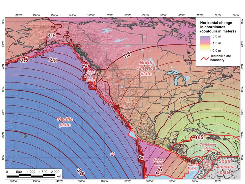
“The four new horizontal or terrestrial reference frames (TRFs) are each referenced to a specific tectonic plate, as indicated by their names: North American Terrestrial Reference Frame of 2022 (NATRF2022), Pacific Terrestrial Reference Frame of 2022 (PATRF2022), Mariana Terrestrial Reference Frame of 2022 (MATRF2022), and Caribbean Terrestrial Reference Frame of 2022 (CATRF2022). We have selected these tectonic plates because they encompass the US landmass and our territories,” said Dennis. “Since tectonic plates are continually moving, the TRFs will move at the same rate (or be “plate fixed”) to the rigid portion of their respective plates to maintain the accuracy of each TRF.”
The new geopotential datum will be called the North American-Pacific Geopotential Datum of 2022 (NAPGD2022). Unlike the TRFs, there will be only one, and it will be built on a reference geopotential model that is global in extent (but of limited resolution), called the Geopotential Model of 2022 (GM2022). From that global model, higher resolution and more accurate regional products will be built. The three primary regional products will be a model of the geoid surface (GEOID2022), a model of deflection of the vertical (DEFLEC2022), and a model of gravity at the ground surface (GRAV2022). These regional products will be in grids, covering three separate regions. The first, and largest, will span from the equator to the pole, and from 170 to 350 degrees east longitude (10 to 190 degrees west longitude). That doesn’t include all US territories, so there will be two additional, smaller regions, one for Guam and the Mariana Islands, and one for American Samoa.
According to Dennis, the data for building the geopotential datum is currently being collected and processed in a massive airborne gravity measurement project under way throughout the US and its territories, called Gravity for the Redefinition of the American Vertical Datum (GRAV-D). The project began in 2009, and the NGS is more than halfway done, but it won’t be finished until 2022. Although the NGS can pretty much determine the four new TRFs now, it decided to make these major changes simultaneously, so everything will be completed and released in 2022.
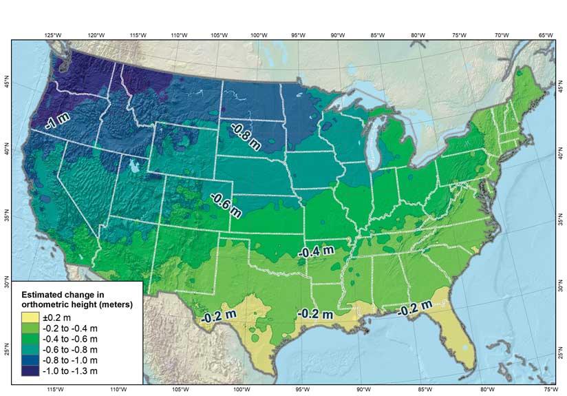
In addition, these are intended to be highly integrated systems. The historical separation of horizontal and vertical will no longer really apply. It will be a 3D system. Actually, it will be a 4D system, because it explicitly includes time. In addition, the new datums will also be aligned to the International Terrestrial Reference Frame (ITRF), which is geocentric, meaning that the origin of the ITRF is at the true center of the earth. The reference ellipsoid of NAD 83 is about 2.24 meters from the true geocenter.
“It is called a geopotential rather than a vertical datum because the vertical component is only part of the new datum. That’s the part used to determine orthometric heights (elevations) and other gravity-based physical heights. It will also provide a model for the deflection of the vertical (the direction of gravity with respect to the TRFs), surface gravity, and other elements of the earth’s gravity field,” said Dennis.
Greater Datum Accuracy Provides Wide-Ranging Benefits
Organizations that require high accuracy in their mapping applications will likely be early adopters of the new reference frames and geopotential datum. This includes engineering and surveying firms; the transportation, utility, aviation, agriculture, and construction industries; and those agencies monitoring weather forecasts and climate change. Companies involved with autonomous vehicle navigation will also find the new datums very useful.
Because the new reference frames and geopotential datum will be based on highly accurate measurements, the consistency will make spatial analysis and aligning spatial data much easier and more reliable, which is a clear benefit for the GIS professional.
Efficiency will be another big motivator for using the new datums, especially in the vertical. The ability to get accurate elevations from satellite data in mere seconds will be a tremendous benefit. The goal is to provide GNSS-derived orthometric heights at an absolute accuracy of 4 centimeters (at 95 percent confidence).
In addition, those organizations that do business with federal agencies that have adopted the new reference frames and geopotential datum will likely also be required to use them. Most federal agencies should adopt the new reference frames and geopotential datum fairly quickly, since they are required to use the NSRS.
Some Implementation Challenges Are Anticipated
“Geospatial software vendors like Esri will have the defining parameters for the new TRFs and geopotential datum well in advance of our official release,” said Caccamise. “So there should be no problem for GIS professionals to select the TRF that is appropriate for their work from preloaded menus.
“The hard part will be dealing with the many exabytes of data found in legacy datasets. NGS will provide tools and algorithms for transforming from NAD 83 (2011/PA11/MA11) to the new TRFs, and from NAVD 88 (and the various island datums) to NAPGD2022,” said Caccamise. [NAD 83 (2011/PA11/MA11) refers to the most recent realization of NAD 83 resulting from the National Adjustment of 2011 Project: NAD 83 (2011), NAD 83 (PA11), and NAD 83 (MA11) Epoch 2010.00. The realization names, in parentheses after NAD 83, consist of the datum tag, which indicates the tectonic plate to which the coordinates are referenced and the year in which the realization was completed with the epoch date in decimal years. The datum tag 2011 refers to the North America plate, PA11 to the Pacific plate, and MA11 to the Mariana plate.]
The hope is that this will satisfy many—if not most—users. However, such transformations may not be sufficiently accurate for some high-accuracy datasets. In such cases, reprocessing or readjusting data within the new TRFs and NAPGD2022 will be necessary to preserve the accuracy of the datasets as originally derived from physical observations. That could prove a major undertaking for certain datasets, and the cost of reprocessing will need to be weighed against the level of improvement in accuracy, as opposed to simply using the transformation tools provided by NGS.
“Another thing that will be new for a lot of GIS professionals is dealing with time-dependence. This also represents a considerable challenge for the software vendors. While it is true that NGS will create new reference frames that move with the tectonic plates, there are areas where the horizontal component of the Intra-Frame Velocities (IFVs) will be too great to ignore (such as the western US and Alaska). And even in areas where the horizontal component of the IFVs is negligible, there could still be significant vertical motion (like the subsidence region along the north coast of the Gulf of Mexico). Don’t forget, the IFVs are three-dimensional velocities. No matter how sophisticated the model and software, user education will have to be part of any successful implementation,” said Caccamise.
Looking to the Future
“As part of the new 2022 TRFs, NGS will create the State Plane Coordinate System of 2022 (SPCS2022),” said Stone. “We will seek input from stakeholders throughout the nation on what characteristics they would like to see in SPCS2022. We expect responses will range from keeping the projection zones essentially as they currently are to states that want only a single large zone, while other states will want a large number of small zones. It will be very interesting to see the types of responses we receive and how they will impact SPCS2022.”
In addition, in most states, NAD 83 is specified as the official geodetic system for surveying and mapping, usually in the context of state plane in state legislation. Obviously, such statutes are not consistent with the new 2022 reference frames and geopotential datum. Last year, NGS, in conjunction with the National Society of Professional Surveyors (NSPS) and the American Association for Geodetic Surveying (AAGS), drafted a model law template for use by states in updating their statutes. The main thrust is to get away from specific names of datums and adopt generic terminology (for example, the National Spatial Reference System or its successor). “Another goal is to remove the defining parameters of state plane from statutes and place them where they can be more easily modified, such as in administrative rules. NSPS will work with states to adopt the new templates,” said Stone.
“We are leaving behind forever the idea of static, unchanging spatial reference systems. This has been well-known in the geodetic community for some time. NGS is creating models, tools, and best-practice guidance for transitioning to and using the new reference frames and geopotential datum. But the details of making all of this work for the many applications that exist—and will be created in the future—still need to be dealt with. There is still much to do between now and 2022, for both NGS and our customers and partners,” Stone concluded.
About the author