Drones have many uses on academic campuses, including research, maintenance, inspection, and certification training. But campus drone use can present challenges, including ones related to liability and privacy concerns.
The facilities services department at the University of California (UC), Berkeley, faced these issues and more. One complication was a construction site, where union rules prohibited drone use. Another complication was related to some local residents whose presence results in an ongoing no-drone zone: peregrine falcons, including one known as Annie that has nested on the university’s bell tower since late 2016.
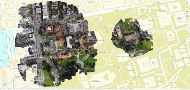
Despite these issues, a drone operator from Esri’s Berkeley R&D office was able to fly a drone over parts of the campus, with the images later processed by the Esri team using ArcGIS. The results allowed facilities services staff to identify areas requiring maintenance and further inspection, explore integration with their current asset-management system, and make the campus safer—all while laying the groundwork for future drone imagery projects.
Suggesting a Proof-of-Concept
UC Berkeley’s facilities services department’s responsibilities range from managing custodial services to maintaining hundreds of buildings and other structures across the campus. Within this department is a GIS, mapping, and drawing group that is responsible for mapping the campus’s built environment, according to Maianna Voge, the group’s supervisor.
“We map the campus landscape, maintain floorplans for nearly 200 structures, and maintain a collection of campus drawings,” she said, adding that UC Berkeley has an aging campus with a lot of ongoing maintenance needs.
So when Esri suggested conducting a proof-of-concept drone flight to gather high-resolution images of campus rooftops, Voge had a few reservations about the idea. She noted that no one at the department had previously considered using high-resolution images of rooftops. The flight was seen by her team as an experimental approach to gathering campus imagery.
“I was skeptical of the concept, although I knew that using drones is easier and safer than putting a human up on a roof,” Voge said. “I figured it would be valuable, but I was concerned about the frequency needed for drone flights. There are all kinds of drone restrictions here—and we don’t want to be the people who take down the beloved UC Berkeley peregrine falcons.”
Also, the UC Center of Excellence on Unmanned Aircraft System Safety has a lot of rules and requirements, Voge noted, adding that the drone flight had to be scheduled around campus events, including football games and political protests.
“There were a lot of boxes to check,” she said. “We wound up doing the flight on a Monday during spring break,” which kept the rest of the week available in case of adverse weather or other delays.

A Successful Experiment
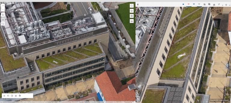
An Esri-certified drone operator planned and managed the flight using ArcGIS Flight. The Esri team then stitched the photos together using Esri’s photogrammetry software, Site Scan for ArcGIS, which allowed for flexible processing in the cloud and creation of imagery products using solutions such as True Orthophotos, digital surface models, point clouds, and 3D meshes. Esri staff then embedded the imagery products into ArcGIS Experience Builder, with features such as orthomosaics, 3D textured meshes, and an oriented imagery viewer–used for later review by the facilities services department and other drone stakeholders at the university.
The drone imagery helped facilities services staff quickly identify a potential safety hazard—a section of roof flashing that had become completely detached. And on another building, staff noted that some building materials had been left behind in some hard-to-reach areas.
“I was pleasantly surprised by the results of this flight,” Voge said. But the flight would have been considered a success even without this accomplishment, she added.

“It sounds like a low bar,” Voge explained, “but just flying a drone over the campus and nothing going wrong was a win. We now know that it can be done safely. In the end it was low effort for high reward.”
Additional Drone Projects Possible
The project’s success led to plans for more drone flights and potential student involvement. Facilities services staff plan to repeat the flights annually, and staff in other university departments, including faculty and graduate students, have expressed interest in using drones for academic research and sustainability projects. Other potential uses include surveying rooftop equipment as well as enhancing fire prevention and mitigation, as the UC Berkeley campus extends into forested hills.
“Collaboration for other projects is going to require a lot of planning and effort,” Voge said, “But we’ve seen this beautiful proof of concept, and I’m optimistic that more drone-supported GIS projects can succeed and provide value here.”
Additional Information
- Read about ArcGIS smart campus operations.
- Learn more about University of California drone safety guidelines and policy.

