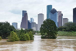
Last August, torrential rains triggered by Hurricane Harvey swamped Fort Bend County, Texas, southwest of Houston, forcing some residents to flee their homes for higher ground.
While the skies soon cleared, the flooding in some areas persisted for days, preventing some people from returning to their houses. Frustrated and frightened, community members demanded to know the status of their properties. Were their homes or yards still flooded? Were the waters receding?
For people who lived in the Canyon Gate at Cinco Ranch subdivision in Katy, Texas, the answers came via an online app called the Panoramic Imagery Viewer, created by Esri emerging business partner GroundVu. The app, built using Esri’s ArcGIS API for JavaScript, provided 360-degree, panoramic imagery of every home and yard along the streets of the subdivision. The images could be viewed by clicking on a location on an ArcGIS Online web map that was embedded in the app.
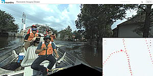
Loaded with thousands of images taken by a panoramic camera from the streets in front of the homes, Panoramic Imagery Viewer gave both county officials and neighborhood residents a timely and up-close look, revealing which properties remained flooded and to what extent.
“It’s a ground-level view of what’s going on,” said Myles Sutherland, chief executive officer and geographer at GroundVu, a company based in Santa Monica, California.
Having little or no visibility of the level of flooding and damage in residential and business areas, staff at Fort Bend County turned to outside expertise for data and maps that would help in disaster recovery efforts and provide residents with much-needed answers to their questions. The Fort Bend County Office of Emergency Management reached out to Texas A&M University, which runs the Center for Robot-Assisted Search and Rescue (CRASAR) engineering experiment station.

CRASAR activated the Roboticists Without Borders (RWB) a group of volunteer experts trained in disaster response. Members of the group came from companies and universities and brought with them a fleet of drones to capture the much-needed imagery. Startup GroundVu was among those organizations answering the call. While other volunteers were flying drones to obtain aerial imagery of the flooded areas, GroundVu offered a different type of situational awareness: 360-degree panoramic images captured on the ground by using the company’s custom-made, vehicle-based pod mobile mapping system.
Reporting to the emergency operations center, Sutherland teamed up with the US Army Corps of Engineers and the Army National Guard. The team requisitioned an airboat that could skim the top of flooded streets with little chance of colliding with submerged objects. Team members attached the company’s mobile mapping system, with a built-in GPS, to the prow and hoisted the airboat onto a trailer bed. Using the highway as a boat ramp, they launched their skiff into the waters.
The GroundVu crew motored through the flooded streets of Canyon Gate at Cinco Ranch, capturing 360-degree panoramic images at one-meter intervals. The photographs show floodwaters lapping against fences and houses as well as the cars and trucks that were parked in driveways. The crew went out a second time in an Army National Guard high-water vehicle and captured more images, which were provided to Fort Bend County.
“GroundVu responded to the county’s request for ground-level images incredibly fast,” said Michael Wainright, GIS director at Fort Bend County. “As GroundVu continued to map a number of neighborhoods, the ground-level images provided a perfect complement to our drone images.”
The GroundVu application was built using ArcGIS API for JavaScript and the ArcGIS REST API. The application was hosted in GitHub. The images and maps are consumed from the Fort Bend County’s ArcGIS Online organization.

GroundVu’s Sutherland received access to a Fort Bend County ArcGIS Online organizational account, giving him the ability to upload and store the imagery and map data and create feature layers for the map. He said he used the ArcGIS REST API to process the images, run scripts, and automate the task of uploading about 10,000 images. When field crews collected new data, the software updated the database and the image viewer displayed new images.
The Fort Bend County website provided a link to the Panoramic Imagery Viewer. Residents of Canyon Gate at Cinco Ranch used the map in the app to see the flooding situation around their homes. By clicking an orange dot of a residential location on a street map, homeowners viewed a panoramic image of their homes’ exteriors and panned to see the condition of adjacent homes. The app verified whether homes were flooded and at what level. The app also was embedded into a Houston Chronicle news story about the flooding in Canyon Gate at Cinco Ranch. And the county judge—who oversees the county government—used the imagery to decide when people could return to their homes, Sutherland said.
Drone imagery of the flooding was posted on YouTube, but the drones flying over the area had to contend with dangerous power lines along with clouds and trees that blocked the view. The GroundVu team captured images without these obstacles, providing greater insight. Moreover, the GIS component of the solution added geographic and spatial context to the imagery data so that it could be mapped.

“While drone video provides a good overview of an emergency situation, GroundVu’s 360-degree images provided us with an address-level view of the front of people’s houses and allowed us to estimate the amount of water in each home,” Wainright noted. “We were able to use the 360-degree view to verify the extent of the flooding, through an online map interface.”
Private and public access to the content was managed by the county so that it could use the imagery and maps for its own purposes via an internal web application and then make selected content available to residents.
Sutherland returned to Fort Bend County shortly after the flooding had subsided and, once again, put GroundVu’s mobile mapping system to work—this time to assist in the county debris and damage assessment efforts. Residents had cleared their homes of ruined carpet, furniture, and other household items, piling the debris in their front yards to be cleared away by garbage collection crews.
GroundVu’s image collection and application viewer helped to quickly review the debris piles, allowing the company overseeing debris collection to assign the correct number of workers and trucks to the area. This saved valuable time and resources during disaster cleanup operations.

The GroundVu team will continue to work with CRASAR on disaster response, as well as with the Esri Disaster Response Program by deploying GroundVu’s vehicle-based and aerial imagery collection pods to provide comprehensive sets of image products.
In the aftermath of future disasters, the use of planes, drones, and ground-based panoramic imagery will enable rapid insight into the situations that responders and recovery teams face.
Learn more about GroundVu by watching this video interview with Sutherland.