A Planning Agency in Kentucky Uses Drones and GIS to Lower Costs and Increase Efficiency
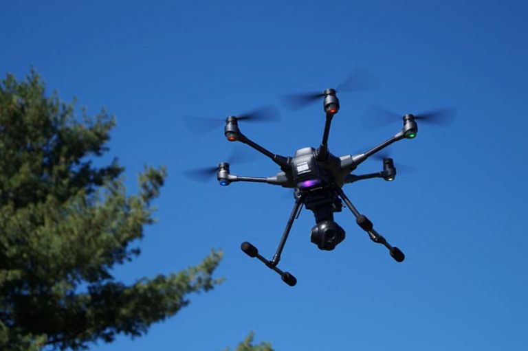
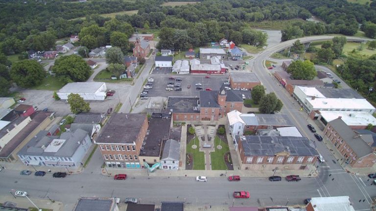
When Planning and Development Services of Kenton County (PDS), a planning agency serving Kenton County and 19 cities in Kentucky, needs to collect data for planning studies, add data to its enterprise GIS, conduct inspections, or assist first responders, it turns to its drone. PDS and LINK-GIS, a three-county geographic information system in Northern Kentucky, introduced drone capabilities to its planning and GIS programs in 2017, purchasing a Yuneec Typhoon H hexacopter. The drone has been used for more than 50 projects involving infrastructure, land development, zoning and planning, conservation, and disaster response. PDS also uses ArcGIS Drone2Map from Esri to process drone imagery.
PDS delivers services critical to growth and development for Kenton County and 19 cities in Northern Kentucky, all part of the Cincinnati metro area. Those services provide a modern platform for land development and include long-range planning; zoning; infrastructure engineering; GIS; building codes administration; code enforcement; and most recently, drone services. The use of drone technologies in projects has not only saved PDS and its partners time and money, it has also led to new workflows, efficiencies, and best practices in Kenton County.
The staff at PDS and LINK-GIS views the drone system as the future: an excellent tool for use in data collection, emergency services, inspections, imagery collection, and 3D modeling. Data collection via drones leads to clearer decision-making and more impactful actions.
ArcGIS Drone2Map processes 2D and 3D imagery, creating orthomosaics, topography, hillshades, and 3D point clouds to be used with GIS data for further analysis. Images captured by the drone store latitude, longitude, and elevation data. Drone2Map takes these values and uses them in orthomosaic processing.
Drones, also referred to as unmanned aerial vehicles (UAVs), are being rapidly adopted in many industries, including local government.
According to a December 2019 Business Insider article by Divya Joshi, drones have become central to the functions of various businesses and governmental organizations over the past few years.
“Adoption of drone technology across industries leapt from the fad stage to the megatrend stage fairly quickly as more and more businesses started to realize its potential, scope, and scale of global reach,” Joshi wrote.
For PDS, the use of drone technology improves data for various planning studies, supplements data that is contained in its GIS, assists first responders, and documents current-day conditions on the ground across Kenton, Campbell, and Pendleton counties. The drone services offered by PDS are commercial-grade, Federal Aviation Administration (FAA) Part 107-licensed activities.
With the drone and ArcGIS Drone2Map, PDS and its partners have saved time and money, improved safety, and introduced a useful new tool for project workflows.
Drones can cover a larger area more quickly than people on foot or in vehicles, making them more efficient for gathering data. Drones can safely access hard-to-reach places that are often hazardous for people, such as water towers and building roofs. Drones are also ideal for use in areas that have experienced hazardous conditions such as fires or natural disasters, including flooding.
The Typhoon H hexacopter is only operated by PDS employees that are FAA Part 107-licensed pilots. The license is required by the federal government for operating a drone under 55 pounds for commercial use. Agencies and businesses that partner with PDS can contract the drone service.

Working with drones and Drone2Map has created new workflows, efficiencies, and best practices in Kenton County. The examples in the following sections demonstrate the broad applicability of drone technologies and ArcGIS Drone2Map across many industries.
Right-of-Way Engineering and Infrastructure Inspection
PDS first tested drone technologies in 2017 as part of a project related to what were updated subdivision regulations in Kenton County. Subdivision regulations outline the requirements for the division and development of land against predetermined standards. They are designed to guarantee adequate streets, utilities, drainage, and means of vehicular access such as entering and leaving the development.
In August 2017, the drone was used to capture images and video of several miles of recently paved streets and newly installed curb and gutter infrastructure quickly and efficiently. In the past, taking photos and videos of this type of infrastructure was very time-consuming to perform manually.
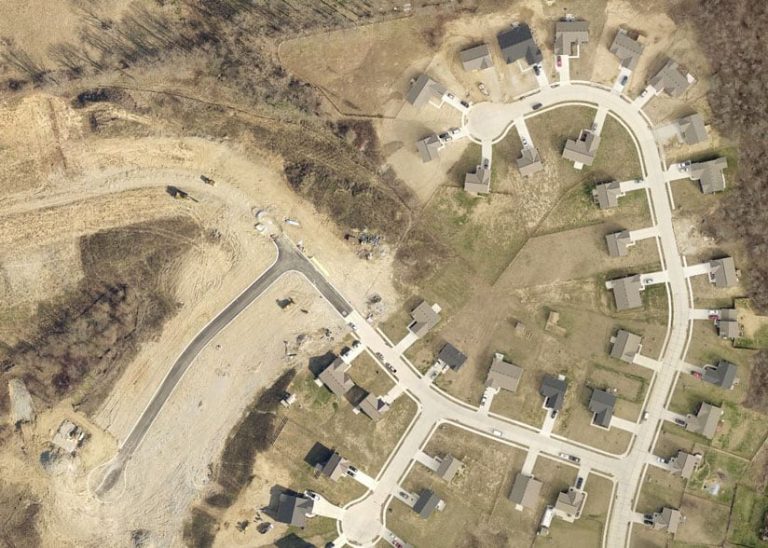
A redesigned curb specification and an improved concrete formula established by the new subdivision regulations prompted a need to see how daily use and weather elements would affect the integrity of the curb and gutter structures over time.
ArcGIS Drone2Map was used to create orthomosaic aerials and digital surface models (DSM) of the new infrastructure. The drone photographed 11 streets over a two-month period, and this work provided a baseline for further study on any deterioration to the infrastructure.
Monitoring a Grass Fire for Flare-Ups
Several years ago, the PDS drone assisted firefighters who were battling a blaze in an isolated area of Kenton County. First responders had received a call about an uncontained grass fire burning along a set of railroad tracks. The fire stretched along the sides of the train tracks for 2,300 feet and was thought to be caused by sparks from a freight train’s locked-up wheel bearing.
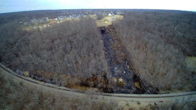
With limited access points to the area where the fire was burning and difficult hilly terrain, the movement of workers, equipment, and resources was slow. By positioning the drone pilot next to the incident response command team, command staff could see real-time images and videos coming from the drone of fire hot spots on the pilot’s remote control device, which was equipped with a live-feed video screen.
The drone flew over hard-to-reach areas and assisted the firefighters in detecting possible flare-ups using real-time video. By flying above the fire, the drone was able to quickly scan from one end of the fire scene to the other.
The drone was also used to collect data from the incident. Images, videos, and orthomosaics were captured to give a detailed after-action report. Drone2Map was used to create these imagery products back in the office.
According to Erlanger Fire/EMS Chief William “Todd” Whitaker, “The quick response and willingness of PDS to not only respond but support incident operations assisted [us] greatly with controlling and safely concluding the incident. Drone footage was essential in allowing the incident command [team] to determine where best to disperse fire attacks over a large area.”
Drone Monitors Flooding along the Ohio River
In February 2018, the Ohio River and its tributaries rose to over 60 and a half feet, 34 feet above normal level, and almost 9 feet above flood stage, resulting in the highest flood level Cincinnati and Northern Kentucky had experienced in over 20 years.
In coordination with first responders, PDS flew the drone over flooded neighborhoods along the Ohio River, inspecting houses that were inaccessible to first responders because they were often surrounded by high waters. The drone was sent to determine whether the homes remained occupied, providing real-time video to an incident command team. Watch the video captured by the drone.
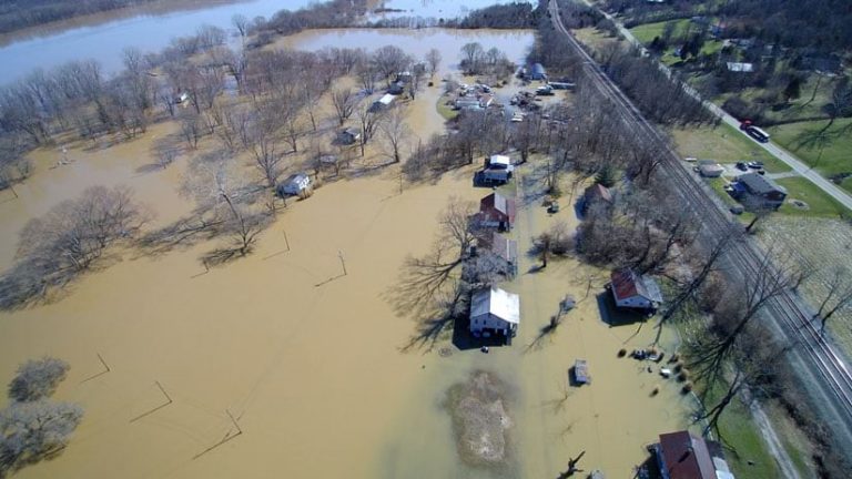
This helped keep first responders safe because they were not being sent to check empty homes unnecessarily.
In addition to personnel safety, the drone proved valuable for flood data collection. Drone photography documented flood levels to better understand the current flood extents, future flood events, and response efforts. This data was considered an in-kind contribution to the United States Geological Survey (USGS) efforts, which meant that an additional $18,000 in grant monies originally committed to data collection could now be used for stream mitigation efforts.
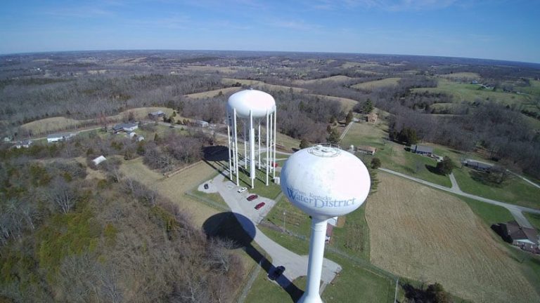
Drones Inspect Water Tanks
Traditional water tank inspections take a two-person team about four hours to complete and require several Occupational Safety and Health Administration (OSHA) protocols, including using safety harnesses when climbing to the top of the 150-foot towers.
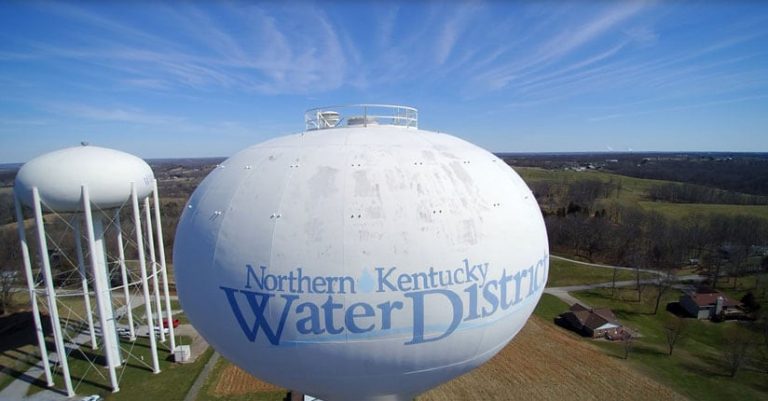
Drone inspections of water tanks have been conducted with the PDS drone and lasted only 10 to 15 minutes. Not only does the drone inspection save time and money, it added an element of safety by keeping human inspectors on the ground and protected from possible injuries.
The Northern Kentucky Water District (NWKD) received an inspection quote of $27,000 for the entire system of 18 tanks, or $1,500 per tank inspection. Water tank inspections performed by the drone were of higher caliber and cost NKWD $900 for the entire system—a price that included travel, flights, and postprocessing. The use of a drone resulted in a savings of $26,100 for NWKD.
Conservation—Kenton Conservancy
Wolsing Trails Nature Preserve is a conservation property owned by the Kenton Conservancy. The 42-acre area is in Independence, Kentucky, and sits along Banklick Creek.
The Banklick Watershed is one of the most developed in Kenton County. The Banklick Watershed Council received a grant to study the area and convert portions of the 42-acre property into wetlands. The newly created wetlands will act as retention areas for floodwaters, holding the water and then slowly releasing it back into drainage channels, which will reduce erosion and flooding downstream.
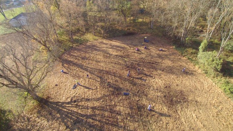
The drone-captured images that are being used to provide project documentation will help officials better understand the before- and after-mitigation project impacts.
Fort Mitchell Parking Study
The City of Fort Mitchell, Kentucky, asked PDS to provide technical assistance with data collection for an economic development study. The drone was used to study parking supply, demand, and usage patterns over time in the city’s compact downtown business district.
Rather than using teams of people to walk the parking lots and physically count cars, the drone gathered aerial photos at certain times throughout the day. The drone can be programmed with a flight path, which can be reused in the future. This flight path allows the drone pilot to capture images of the same area in a consistent manner—the same location and elevation—each time. These drone images give planners more accurate parking counts as well as visual representation and data which they can use to analyze more efficiently.
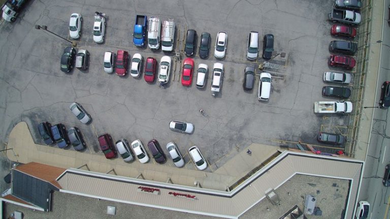
PDS used Drone2Map to create orthomosaic images and digital surface models (DSMs) to further incorporate with the parking study.
Future Drone Applications
PDS has been widely recognized for its innovative use of drone technologies. In 2018, the Urban and Regional Information Systems Association (URISA) awarded PDS the URISA Distinguished System—Exemplary Systems in Government Award—Single Process System Category, for its innovative use of drone technologies in government operations.
In addition to this national award, the PDS drone services program received two state awards—Exemplary System from the Kentucky Association of Mapping Professionals and Outstanding Use of Innovative Technology from the Kentucky Chapter of the American Planning Association.
PDS employees and their partners are not done innovating yet. They continue to push into new territory with drone use. Aerial photos and products from the PDS drone are being used to update existing land-use GIS data, document and observe sinkholes, record and study active shooter drills, observe landslide activity, assist with accident reconstruction, and even perform impromptu building inspections.
Images obtained only from the drone’s perspective identified missing shingles on top of a 171-year-old antebellum era county courthouse in Pendleton County. The county’s judge executive (the highest elected county official in Kentucky) claimed a savings of $10,000 from preventative water and roof damage due to early detection.
Follow PDS and its partners on Twitter at @PDSKC, @LINK_GIS, and @NKYmapLAB. PDS is online at pdskc.org, and LINK-GIS is online at linkgis.org.
About the authors

Trisha Brush