Cycling Organization Accurately Maps Mountain Bike Trails in Québec, Canada
Cycling is a popular sport and pastime in the Canadian province of Québec, and for good reason.
Canada’s largest province by area, Québec offers a massive trail network with world-class biking trails. Bike-friendly routes go past scenic lakes, rivers, and farms; through forests and quaint towns; up and down hills and mountains; and into the heart of vibrant communities such as Montreal and Québec City. The province’s most famous bike network is Route Verte, or Green Route, which comprises more than 5,300 kilometers of trails.
For cyclists to take full advantage of Québec’s trails, they must be mapped and maintained. As a nonprofit organization that promotes bicycling for recreation, health, tourism, and environmental reasons, Vélo Québec took on the charge of mapping trail networks—including Route Verte—for the province. The mapping initiative, supported in part by GIS technology from Esri, aims to help develop mountain biking trails specifically and promote their use.
“This project is very dear to me,” said Francis Tétrault, mountain biking project manager for Vélo Québec and an avid mountain biker for 20 years. “We currently have over 500 kilometers mapped this season in the first installment of our project.”
Tétrault has made it his mission to help perpetuate trail networks, as he has seen too many disappear due to poor planning and maintenance and loss of landowner permissions. Ideally, Tétrault and the team at Vélo Québec are mapping every kilometer of the mountain bike trails in the province and adding every new official trail to the organization’s database.
Enter Esri and Eos Technology
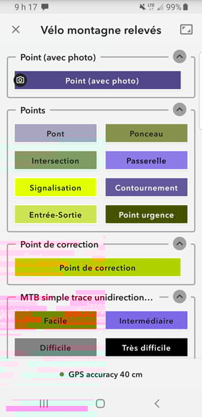
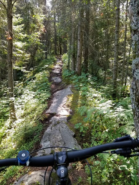
Recently, accurate data was collected on mountain bike trails by using ArcGIS QuickCapture from Esri, along with high-accuracy Global Navigation Satellite System (GNSS) receivers. The data collected by Tétrault and his team included points and polylines that show the trail locations from start to finish; the length, directionality, difficulty level, and surface type of each trail; signage; and the obstacles cyclists might face.
ArcGIS QuickCapture is a mobile app specifically designed to rapidly collect field data. The app lets people record data with one tap of a large button and transmit the information back to a database in real time.
To improve on the spatial accuracy of the data captured, Vélo Québec paired the field collection app with high-precision GNSS receivers from Eos Positioning Systems. Its Arrow 100 receivers provide submeter location accuracy when data is being collected in the field.
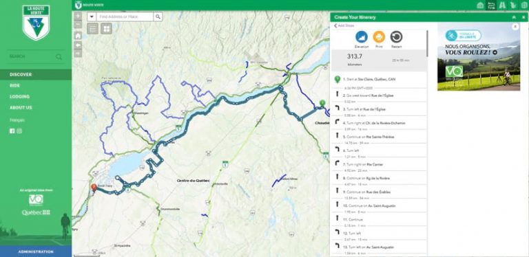
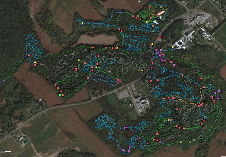
Vélo Québec offers training to cyclists and hosts cycling events and trips. The organization needs precise data to support its work, including administering risk management, maintaining trails,, and amending right-of-way agreements with landowners. The collected data will also support other goals in the future, such as updating trail maps. (See the organization’s interactive online trail map, hosted in ArcGIS Online. While mountain bike trail data collected for Tétrault’s project isn’t on the bilingual interactive map, people can view a network of the Route Verte paved trails by using tools to look up routes, create itineraries, and find places to stay such as campgrounds and hotels.)
In many instances, trails in Québec are built on private land. Cycling clubs, which are the organizations that develop the trails, must acquire permission from landowners to build trails on their land. Accurate trail mapping is helpful to acquire permission to develop trails. For example, the maps can show what portions of a proposed trail might be on a homeowner’s land.
Hurdles to Overcome
A network of Vélo Québec staff or volunteers—who sometimes are not versed in GIS—create and maintain up-to-date trail data. Consequently, the data-capture process out in the field must be easy, and the training needed to do it must be minimal.
Working remotely in areas without cell coverage and using technology under varying light and temperature conditions can add another layer of challenges.
Data is captured by people while they’re riding a bicycle, so having lightweight, compact, durable equipment is critical.
Data collection must also produce accurate data. Before this initiative, land managers had data that was largely gathered by smartphones (precise to about 14–16 meters) or handheld GPS systems (precise to around 4 meters). The low level of precision impacted data and analysis, so the Vélo Québec team needed a tool to improve accuracy.
“Because of that low level of precision, you could see lines crossing and being superimposed [when collecting trail data], especially when tight hairpin turns were concerned, which is a regular occurrence in modern bike trails,” Tétrault explained. “There [are] a lot of variables that make the [tracks] less precise.”
A Simple, Big-Button Experience
The Vélo Québec team wanted an easy-to-use, highly accurate, and compact field data collection solution, which is why ArcGIS QuickCapture was selected for this project.
The mobile app’s simple, big-button user experience requires little training and runs on consumer iOS and Android devices, so anyone with either platform can load it on their phone.
The app records and transmits data from the field, with the complementary Arrow 100 receivers improving the spatial accuracy of the data that is captured.
Due to severe snow conditions in Québec, the first field tests were not possible on a bicycle. Instead, the mobile solution and receivers were put to the test by Tétrault while he went ice skating on a lake near the Vélo Québec office. Tétrault says the results were remarkable: QuickCapture was easy to use, the receivers were easy to carry, and the data was very accurate. The receivers and QuickCapture app on mobile devices, used simultaneously, were able to precisely map and attribute the tracks on ice.
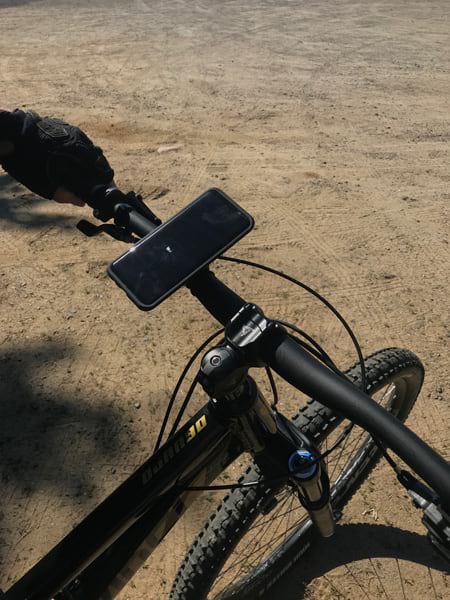
The next step was to prepare each of the complementary devices for use on mountain bikes in the spring. A smartphone with the mobile app was attached to the bicycle’s handlebar, and the GPS receiver’s antenna was mounted on the rider’s helmet. The receiver itself was in a hydration pack worn by the technician. The receiver was configured to stream locations to the app at 2 Hz (two positions sent per second) to improve the granularity of the tracks captured.
The receiver was also configured to enable documenting different sorts of field observations: photos of the trail, obstacles, bridges, and intersections; the difficulty and category of trails mapped; and polygons captured for trailhead parking lots and buildings.
“The development of this methodology is breaking news for our field and has been very well received,” Tétrault said. “We now have a quality solution for gathering data that wasn’t possible before.”
Simpler Data Collection
QuickCapture has allowed Vélo Québec to simplify data collection and improve data processing. The process is now digitized and more streamlined.
The old method of collecting data on the trails involved using a handheld GPS device to generate waypoints or polylines. Then, data was transcribed in a notebook and later entered into a spreadsheet to populate the attributes related to each point, such as the width or difficulty level of the trail. This old method was cumbersome and opened the door to data entry mistakes that would be hard to track afterward.
Now, the app provides individual buttons for all the types of features recorded on the trails.
“We pick the right trail attributes [and] punch the appropriate button in the app, and the track gets recorded as we follow the trail. And it’s the same thing for observations along the trail,” Tétrault said. “It’s incredibly simple. I see this procedure as less of a chore for volunteers than the traditional method of GPS and paper, and the training is much more intuitive.”
The mobile app is also speeding up the capture of data in the field. “In the short time we’ve been running the app on the ground, we have covered more kilometers in less time than [we would have] with our old method,” Tétrault said. “In one 20-week season, we should be able to cover around 600 kilometers, with an average of 20 kilometers per day. That’s 375 miles for one person, which is a substantial amount.”
Data is now accessible in real time, enabling prompt quality assurance and constant monitoring of progress. Technicians in the field can see if a trail has been entered correctly or call in to have it checked immediately by office staff.
There’s also been considerable improvement in data quality. Tétrault describes the mobile data collection app as a user-friendly solution that is helping Vélo Québec better map and manage trails so that people will have them for generations to come.
“For us, this tool guarantees a uniform quality of the data in the project, which was a big challenge before,” said Tétrault. “I had an idea of the possibilities of GIS before, but this project has opened up a can of ‘wow’ in terms of putting technology in service for a cause.”
To learn more about ArcGIS QuickCapture, watch this video.
About the author