The world is going through some serious changes right now. If you ask city officials what keeps them up at night, the majority of them will say jobs, followed by water scarcity, flooding, traffic congestion and failing infrastructure. For many, it’s the loss of millennials to big cities, or the aging of their population.

That’s just a sample of the concerns I’ve seen as I travel the country and talk with planners, city managers, and elected officials. The solutions are equally complex, from densification and transit oriented development to green infrastructure and other climate adaptation strategies.
You know what else is changing? Technology, and along with that, public expectations. Now, this is nothing new. We’ve been discussing this for five years or so, but the pace is really picking up. Facebook, Instagram, Twitter, and texting are now providing information to people much more quickly than in the past.
Are Planning Departments Being Out Mapped?
This changes the whole paradigm around public participation in the planning process. The spread of open data and easy-to-use mapping applications has made it possible for citizens and advocacy groups to start “out mapping” planning departments.
This may seem daunting, but for those willing to jump in and apply these new technologies to planning, the future is very bright. I believe it is possible to change the face of planning at all levels. The question is whether you want to lead that change, or just react to change.
To add credence to the evolving nature of planning, I just watched a presentation from a highly reputable architecture and urban planning school. All 25 of the graduate students I spoke to were coders. They were developing code to help them solve planning problems, much like the ones I listed above. They were innovative, creative, and I thought, “Wow, this is the future of planning.” My next thought was, “Man, I’m going to have to go back to school.”
What Can You Do to Lead the Change in Your Organization?
First and foremost, planners are going to have to develop new sets of skills. It doesn’t mean you have to learn how to code, many apps are actually what we call, configurable. They come with easy to use templates that you can set up and deploy with just a little training. And if you are an AICP certified planner, you are in luck, Esri now offers APA AICP Credit Maintenance (CM) credits for GIS courses, webinars, seminars, events, and workshops to help you develop some of these new skills while maintaining your professional standing.

Here are some ideas to help you break away from the pack and lead by example in your organization:
- PDF maps are out. Embrace the change and learn how to create simple interactive Story Maps with informative infographics to enhance the way you communicate with the public.
- Citizen planners are in. Harness the power of the “citizen planner” like the Audubon Society is doing with “citizen scientist” by providing easy to use apps using GeoForm that allow citizens to tell you what they want to protect, where the bike routes should be, and where they’d like to see traffic calming or better lighting.
- Mobile is in. Streamline the building permit or land use change request process by building your own inspection app like this Code Violation app. Inspectors will have everything they need at their fingertips to make decisions in the field, instead of revisiting the site 2 or 3 times.
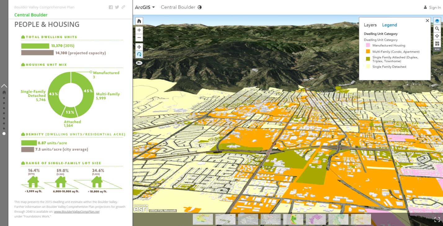
- 3D is in. 3D is one of the fastest growing industries in the world of planning. Convert your 2D maps to compelling 3D visualizations and share them on the web to take the guess work out of how a proposed zoning change might look. The Boulder Valley Comprehensive Plan is a great example of a 3D story map.
Continue to Learn with Esri
The list of Esri-eligible CM credit classes will continue to grow, but here are a few to get you started. And check out the many courses we offer through our virtual campus. Let me know which classes you’d like to see added to the CM credit roster!