This year the City of New Orleans showcased their great work at the Esri User Conference Plenary. A major theme of their presentation was citizen engagement and creating a real two-way engagement enabling citizens to take in civic responsibility. New Orleans is doing outstanding work, and all of the solutions are configurations that can be repeated for any local government.
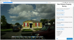
The first demonstration was the Property Survey solution in which we have enlisted User Conference attendees to help survey their properties for blight at https://propertysurvey.nola.gov/photosurvey/ This solution can be useful for a variety of applications such as code enforcement, emergency management assessment or tax appraisers. The Photo Survey Solution from the Esri Solutions gallery will allow you to process geo-tagged photos and an application to set up randomized surveys as New Orleans has done. Since 16,000 UC attendees were enlisted to help assess properties and shared on social media, Esri Managed Services was used to make sure the underlying infrastructure was ready for reliability and scalability.
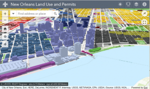
Next showcased was how New Orleans notifies their citizens about the abundant land use changes occurring in the city. A 3D web scene showing New Orleans in a visual environment to depict these changes was presented. Creating 3D scenes are probably closer than you think with the Local Government 3D scene tools and ArcGIS Pro. New Orleans showed their NoticeMe application in which citizens can sign up for planning change alerts in their neighborhood. New Orleans is actively engaging with the community themselves by providing this solution on GitHub.
The Adopt A Catch Basin app was show that allows citizens to adapt a catch basin and clean it to remove future flooding concerns maintaining a resilient city. This will also be a template from the ArcGIS Solution gallery that could be applied to any scenario such as fire hydrants or sidewalk snow removal, check the What’s New documentation in the next release coming in a couple months when this solution will be available.
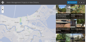
Lastly, New Orleans showcased a Water Management Projects application where residents can share their own projects on how they are better living with water. This template was quickly put together with Story Map Crowdsource template which was just released with the June update to ArcGIS Online.
A huge thanks to the City of New Orleans for sharing their great work with everyone at the Esri User Conference. They are approaching citizen engagement in a way that really creates a smarter community. Hopefully you can find some of the resources above they used in applying to your own organization for citizen engagement.
insider
