The Year in Review for Winter Maintenance Professionals
We all know it has been a tough year, with record snow.
Esri promoted this as the year GIS meets snow and ice removal, in part due to the hard work that transportation and public works professionals deal with on an annual basis. But now that the snow has begun to thaw, it is time to reflect on where and how we could have improved and, more importantly, if a location strategy could have played a more impactful role in supporting the work you do.
Let’s review the following:
- Were you able to collect data on plow locations, areas with heavy snowfall, and higher-than-average material use so you can plan for next year’s operations and the year after that?
- Did you have an effective means of collaborating and communicating with various departments and the public?
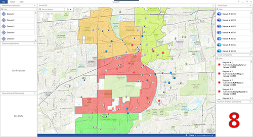
- Did you have the decision-making tools to plan snow farms, efficiently route and predict staffing, and regulate equipment and material use?
- Could you have had a more effective means of monitoring your crews in real time, adjusting to where the real need is, or did you send the plows to the same places you always do?
- Were you meeting the expectations of your citizens and the media by providing them with the information they needed, when and where they needed it?
Esri worked diligently to identify the solutions that could deliver smarter, more effective ways to help you meet all of these demands. The public works and transportation professionals that applied GIS to the questions posed above have experienced a clear return on investment. For example, Pennsylvania Department of Transportation said, “By using GIS tools for Truck Snow Routing, PennDOT identified the potential of savings from $1.5 million to $2.5 million.”
If you’re looking to increase productivity, communication, and cost savings next year, take a look at our prepackaged snow solutions. And make sure to do it before May 1, because that’s when the special pricing expires!
Make sure you’re ready for next year. We’re ready to support you.
Visit esri.com/snowsolutions to learn more.