Create 2D planning scenarios in GeoPlanner and visualize them in 3D in ArcGIS Pro
These are exciting times for the city of Hartford, Connecticut. A new bus rapid transit (BRT) line, CTfastrak, has recently opened, connecting the city to several communities in central Connecticut. Furthermore, minor league baseball is coming to town, as the Hartford Yard Goats prepare for their debut in 2016. The city now faces the challenge of successfully integrating the upcoming sports entertainment development with the new BRT line in order to maximize the impact of both multi-million dollar projects.
As part of the ArcGIS platform, GeoPlanner for ArcGIS and ArcGIS Pro can help city decision-makers and planners understand and visualize the dynamics of urban infrastructure projects as well as help them optimize the impact of these projects. GeoPlanner and ArcGIS Pro offer new opportunities to incorporate GIS into planning and design practices. GeoPlanner allows you to create and assess multiple planning alternatives. ArcGIS Pro helps you understand these alternatives through 3D visualization. The ArcGIS Platform transfers changes between these applications. This enables uninterrupted workflows and helps to facilitate valuable insights.
Create and Evaluate Plans across a Synchronized Platform
Let’s say your organization has GIS professionals who use ArcGIS Pro and a planning team that works with GeoPlanner. The ArcGIS Platform can help these two groups collaborate on projects through the sharing of data, analysis, and information.
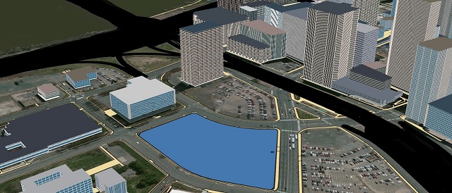
GeoPlanner scenarios and analysis results are saved to ArcGIS Online as hosted feature layers. These layers can be accessed and rendered in 3D in ArcGIS Pro. 3D visualization helps you evaluate the impact of current conditions and proposed changes within your study area. For example, you can explore how the orientation of surrounding buildings affects your proposed development. Valuable insights gleaned from visualizations in ArcGIS Pro promote evidence-based and analysis-driven design alternatives in GeoPlanner.
Changes you make to hosted feature layers are available in real-time in both GeoPlanner and ArcGIS Pro. As a result, ArcGIS Pro and GeoPlanner comprise a synchronized platform for seamless geodesign workflows.
Using GeoPlanner and Pro Seamlessly
Let us now explore how GeoPlanner and ArcGIS Pro can be used in tandem to locate and plan the optimal site for construction of a minor league baseball stadium in Downtown Hartford, Connecticut.
We begin by importing our data into a scenario which will model the current built conditions and zoning districts in Downtown Hartford.
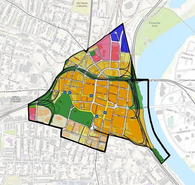
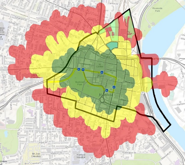
Using analysis tools, sketching tools, and scenarios, we conclude that there are three possible areas of contiguous parcels upon which to construct the Yard Goats stadium. We will determine which site is best positioned to promote use of CTfastrak among Yard Goats fans as they head to the stadium on game day.
This conclusion is best reached by combining GeoPlanner’s analysis tools with its visually instructive classification scales. We see that there is only one contiguous area of parcels upon which to build the stadium in order to promote CTfastrak use among Yard Goats fans.
How Do I Get Started?
Choosing to work with both GeoPlanner and ArcGIS Pro is a smart decision for planners and decision-makers in all industries. Learn more and request a free trial of GeoPlanner for ArcGIS and ArcGIS Pro to start taking advantage of the planning power of these applications today.
insider
