Web maps are online maps created with ArcGIS that provide a way to work and interact with geographic content organized as layers. They are shared on the web and across smartphones and tablets. Each web map contains a reference basemap along with a set of additional data layers, plus tools that work on these layers. The tools can do simple things like open a pop-up window when you click on the map, or more complex things, like perform a spatial analysis and tell you the relative proximity of healthy food options by neighborhood.
At their heart, web maps are simple. Start with a basemap and mash it up with your own data layers. Then add additional tools that support what you want your users to do with your web map: tell stories; perform analytical studies; collect data in the field; or monitor and manage your operations.
Virtually anything you do with GIS can be shared using web maps. And they can go anywhere. Web maps work online and on any smartphone, and along with your supporting GIS work, are accessible anytime.
Web maps are how you deploy your Web GIS. A web map is easy to share with others. You simply provide a hyperlink to the web map you wish to share and embed it on websites or launch it using a wide range of GIS apps.
Make and Share a Web Map in Five Easy Steps
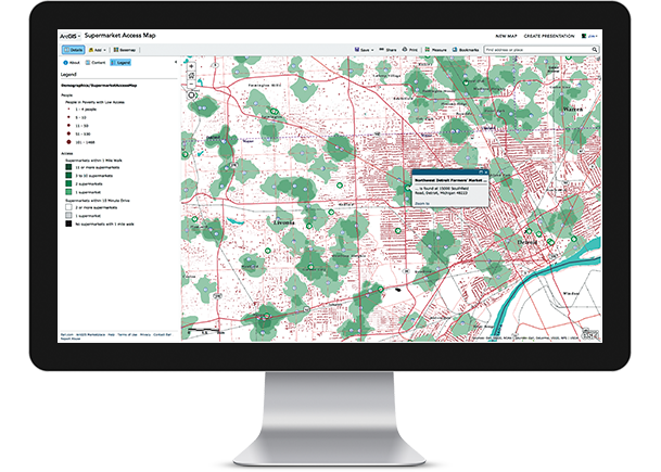
Anyone can make, share, and use web maps. Let’s start by going through a short example. Suppose you want to make a map that allows you to explore the food, architecture, and design destinations for San Diego.
1. Select a basemap and zoom into your city of interest. We’ll use the Light Gray Canvas basemap.
2. Add your data layers and specify how each will be symbolized and displayed. In this case, we’ll add point layers for specific San Diego destinations, line layers for the trolley lines, and neighborhood polygons.
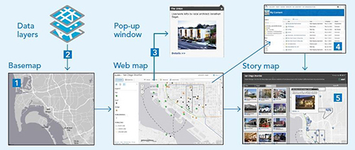
3. Create pop-ups that enable users to explore the clicked-on features.
4. Save your map, then document it with an eye-catching thumbnail, a good description, and a thoughtful name. Every map, especially a map that you will share, needs a good item description, thumbnail, and name.
5. Share your map by using it to configure a whole range of apps. Once you create your map, you can configure an app that will use your web map for delivery to your audience.
This post is excerpted from The ArcGIS Book: 10 Big Ideas about Applying Geography to Your World. The twin goals of this book are to open your eyes to what is now possible with Web GIS, and then spur you into action by putting the technology and deep data resources in your hands. The book is available through Amazon.com and other booksellers, and is also available at www.TheArcGISBook.com for free.
