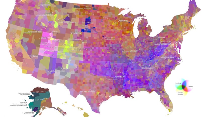
John Nelson
Connect:

I have far too much fun looking for ways to understand and present data visually, hopefully driving product strategy and engaging users. I work in the ArcGIS Living Atlas team at Esri, pushing and pulling data in all sorts of absurd ways and then sharing the process. I also design user experiences for maps and apps. When I'm not doing those things, I'm chasing around toddlers and wrangling chickens, and generally getting into other ad-hoc adventures. Life is good. You might also like these Styles for ArcGIS Pro: esriurl.com/nelsonstyles

Posts by this author
Multivariate maps: what are they and how can I make them in ArcGIS?

Multivariate maps are interesting and informative if done well. Here's an overview, plus some instructions for ArcGIS Pro and Online.

Continue Reading

One Minute Map Hacks: 41-45

Five more minutes of fast-paced high-octane how-to-edness, in one minute bites.

Continue Reading

Create a before-after layout in ArcGIS Pro with Wayback imagery

How to make a side-by-side comparative layout of the same place. Pow! Wayback and Pro layouts have your back...

Continue Reading

Pebbled Hillshade

Mis-using the Vector Field symbology type to create a halftone-like dotted hillshade technique in ArcGIS Pro.

Continue Reading

When your map isn’t ready for primetime

Need to share a map, but don't want to imply that it's complete? Here are eight watermark options you can splatter across your work-in-progress.

Continue Reading

Cool examples from the U.S. Vessel Traffic application from Living Atlas

The U.S. Vessel Traffic app weaves all sorts of accidental lessons in economic geography.

Continue Reading

Texture Tiles

Five texture layers that you can overlay atop your map (in ArcGIS Online or ArcGIS Pro) to give it a nice lived-in feel.

Continue Reading

Create a bold 3D Earth graphic in ArcGIS Pro | pt 2: Atmosphere

How to make one of those glorious vaguely-realistic but-over-the-top detailed earth stock photos. Part 2: Insane Atmosphere

Continue Reading

Create a bold 3D Earth graphic in ArcGIS Pro | pt 1: Terrain

How to make one of those glorious vaguely-realistic-but-over-the-top detailed earth stock photos. Part 1: Terrain.

Continue Reading

1 11 12 13 14 15 37