The ArcGIS for Developers team is proud to announce that the latest Quartz beta releases of the ArcGIS Runtime SDKs are now available!
The evolution of ArcGIS technology has come a long way. If you are focused on creating native apps there’s never been a better time to be an ArcGIS developer.
The Quartz release is the next generation of ArcGIS Runtime. It delivers new and significant functionality that will be making its official debut in the next major release of the ArcGIS Runtime SDKs. The first Quartz betas were released late last Summer for Android, iOS and Java. Now, for the first time, ALL of the Quartz SDKs are LIVE in public Beta, and ready for you to test-drive on your platform of choice. Beta testers can get these SDKs today from the ArcGIS for Developers website.
The Quartz architecture takes the ArcGIS Runtime platform to a new level, allowing your applications to mesh and synthesize with all of the modern advances of the ArcGIS platform as a whole. We are very excited to see how Quartz will fuel your app innovations in the years to come.
Here are the latest features you’ll find in these betas. Some SDKs have betas that have already introduced these capabilities. Some are now live with these capabilities for the very first time:
Online and offline capabilities
APIs for building and supporting both online and offline workflows in your apps is now available in all of the Quartz betas. This includes the classic sync framework and services pattern for editing and data collection. It also includes working with, authoring and modifying 2D Web Maps from portals, as well as accessing maps, layers, locators, and networks from mobile map packages (MMPKs) for using offline functionality in your apps.
3D
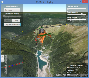
Build apps using Java, .NET, Xamarin, iOS, or Qt to view your online and local data in 3D. Show terrain using online elevation services. Display buildings from a scene service. Use 3D symbology and custom models to render complex 3D graphics. Change camera location and orientation to view scene contents from different perspectives.
Mobile map packages
You might be wondering what these MMPK’s are. A mobile map package is a set of items bundled together into a single file, an .mmpk file, for transport, often for use in offline workflows. You create these in ArcGIS Pro and consume them in ArcGIS Runtime applications, either connected or disconnected from a network. The items are one or more maps, their associated layers and data, and optionally networks and locators. A mobile map package also includes metadata about the package. Maps within a mobile map package follow a specification similar to the web map specification and can contain local feature layers or vector tiled layers.
Vector tile layers
You can use vector tiled layers in your ArcGIS Runtime applications. These layers are similar to raster-based tiled layers but they are faster, smaller, and look better on high resolution devices. They also differ in the way cartography is delivered. Instead of raster pixels, vector tiled layers deliver cartography using vectors so cartography is rendered leveraging all the available pixels on the device. The file format is binary and conforms to the Mapbox vector tile specification. You can use vector basemaps from online, or you can create and access vector tile packages (VTPKs) from your offline applications.
Military Standard Symbology support (2525D)
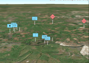
The Qt and Java SDKs introduce the ability to use and customize military standard symbology. The 2525D standard is there now, with the rest of the standards coming in follow-up Quartz releases, so stay tuned.
Direct-read of raster and KML files
For many of you, the ability to directly read raster and vector data from files on the device is critical for building your apps. With the new Quartz betas for .NET, Xamarin, iOS and OS X, you now have support for reading many popular raster formats as data sources for your raster layers in your maps. There is also support for directly reading and using KML and KMZ files, allowing your apps to visualize KML data through feature layers. KML elements such as Placemarks, Folders, Network Links, Screen Overlays, Ground Overlays are supported.
Windows 10
For most ArcGIS Runtime SDKs, this is the first release to support Windows 10. Traditional desktop apps can be built using Java, Qt, or the .NET – WPF API. Universal Windows Platform (UWP) apps for Windows 10 can be built using the .NET – UWP API or Xamarin Forms.
More…
In addition, there are many great new things that are specific to your favorite API. You can read about these now in the release notes for Android, iOS, Java, OS X, .Net, Qt and Xamarin.
You may have noticed that some SDKs have a few features that others don’t yet. For example, .NET and iOS will have beta support for direct read of raster and KML files. Java and Qt have military standard 2525D symbology. Java, Qt, .NET and iOS/OS X have 3D viewing capabilities. This doesn’t mean that functional disparity will always be this way, so don’t be alarmed.
Let’s get started
To get started, browse to the ArcGIS Runtime SDKs home page and click on the API of your choice to get to the beta home page. 
From the beta home page, click “Join the Beta”.
This will launch you to the Early Adopter Community (EAC) page, from which you can download the SDK or reference the SDK from one of Esri’s public repositories.
Resources for beta testers
The Developer’s site is where you’ll access all of the beta SDK resources such as developer guides and tutorials, API references, samples and sample code. The EAC is where you’ll submit feedback and bugs you find, and where you’ll ask questions and share with other beta users through forum posts.
On behalf of the entire ArcGIS Runtime team, we want to say that we’re here to serve YOU, our GIS developer community. Help us by Getting started today with the new Quartz betas, and partner with us in creating a delightful next-generation ArcGIS Runtime experience.


Commenting is not enabled for this article.