Raster analytics using ArcGIS Enterprise is a flexible raster processing, storage, and sharing system that employs distributed computing and storage technology. Use raster analytics to apply the rich set of raster processing tools and functions offered in ArcGIS, build your own custom functions and tools, or combine multiple tools and functions into raster processing chains to execute your custom algorithms on large collections of raster data. Source data and processed results are stored, published and shared across your enterprise accordingly.
This extensive capability can be further expanded by leveraging cloud computing capabilities and resources. The net result: image processing and analysis jobs that used to take days or weeks can now be done in minutes or hours, and jobs that were impossibly large or too daunting are now within easy reach.
What can raster analytics do?
By leveraging ArcGIS Enterprise, raster analytics enables you to:
- Quickly process massive imagery or raster datasets in a scalable environment
- Execute advanced, customized raster analysis
- Share results with individuals, departments, and organizations within or outside your enterprise
Raster analytics is ArcGIS Image Server configured for raster analysis in a processing and storage environment that maximizes processing speed and efficiency. Built-in tools and functions cover preprocessing, orthorectification and mosaicking, remote sensing analysis, and an extensive range of math and trigonometry operators; your custom functions can extend the platform’s analytical capabilities even further.
Fully utilize your existing ArcGIS Image Server on-site, or exploit the elastic processing and storage capacity of cloud computing and storage platforms such as Amazon Web Services and Microsoft Azure to dynamically increase or reduce your capacity depending on the size and urgency of your projects. The scalable environment of raster analytics empowers you to implement computationally intensive image processing that used to be out of reach or cost-prohibitive. This implementation saves you time, money, and resources.
Raster analytics is also designed to streamline and simplify collaboration and sharing. Users across your enterprise can contribute data, processing models, and expertise to your imagery project, and share results with individuals, departments, and organizations in your enterprise.
Finally, Raster analytics using ArcGIS Enterprise integrates your image processing and analysis with the world’s leading GIS platform, and allows users to seamlessly draw on the world’s largest collection of online digital maps and imagery.
How does raster analytics work?
ArcGIS Image Server configured for the role of raster analytics provides software and user interfaces to organize and manage your processing, storage, and sharing of raster and feature data, maps, and other geographic information on a variety of devices. This integrated system manages the dissemination of processing and storage of results (1) on-premises and behind the firewall for classified deployments, (2) in cloud processing and storage environments, or (3) a combination of both environments.
The foundation of raster analytics is ArcGIS Enterprise, which includes an Enterprise GIS Portal, ArcGIS Data Store, Image Server configured for raster analytics, raster data store and ArcGIS Web Adaptor. ArcGIS Enterprise integrates the components of the raster analytics system to support scalable, real-world workflows.
Scale your powerful processing and storage capabilities by deploying ArcGIS Enterprise in the cloud via Microsoft Azure or Amazon Web Services (AWS). For example, you can automatically scale capacity up and down according to conditions you define, or automatically dispense application traffic across multiple instances for better performance. ArcGIS Enterprise makes deployment easier by providing Cloud Builder for Microsoft Azure or AWS CloudFormation with sample templates to configure and deploy your system in the cloud.
Develop, test and optimize your raster processing chains using Esri’s rich set of more than 200 functions and tools in the familiar ArcGIS Desktop or web map viewer. Once verified and optimized in the dynamic on-the-fly processing environment, submit your processing chain to ArcGIS Portal, which manages the distribution of processing, storage, and publication of results.
The ideal deployment of raster analytics is comprised of three server sites to perform the primary roles of the portal host server, raster analysis server, and the image hosting server. Two licenses are required for raster analytics, ArcGIS Enterprise and Image Server.
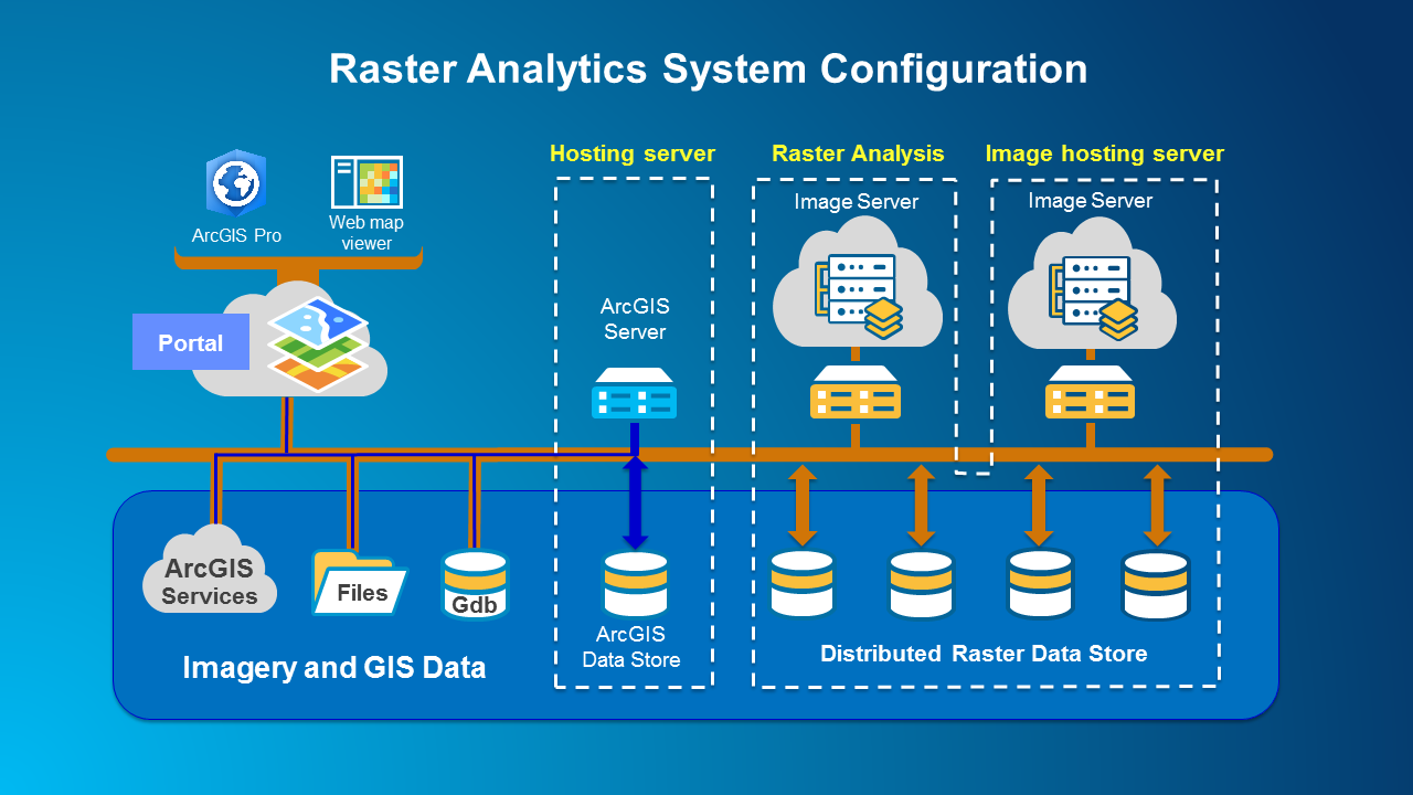
The hosting server is your portal’s server for standard portal administration and operations such as managing and dispensing processing, storage, and publication of results to raster analysis servers, image servers, and data stores. It also hosts the ArcGIS Data Store for GIS data and allows users to publish data and maps to a wider audience as web services.
Raster analytics jobs are processed by image servers dedicated for raster analytics, comprised of one or more servers, each with multiple processing cores. The image processing and raster analytics tasks are distributed at the tile level or scene level depending on the tools and functions used. Raster analytics manages the processing results to either the ArcGIS Data Store on the hosting server for feature data products, or to the raster data store for imagery and raster data products. The raster data store can be implemented using distributed file share storage or using cloud storage such as Amazon S3 or Microsoft Azure blob storage.
The image hosting server hosts all the image services generated by the raster analysis server. It includes the raster data store configured with the Image Server Manager, which manages distributed file share storage and cloud storage of image services using Amazon S3 or Microsoft Azure blob storage. The image hosting server stores and returns results requested by members of your enterprise.
System configuration apps assign the roles of the servers and data stores, and also set the permission structure for all the users across your enterprise. This facilitates optimal flexibility in configuring and implementing your raster analytics system to address specific projects. Multiple servers can be scaled up for raster analytics processing and storage as required.
See the tutorial to set up a base ArcGIS Enterprise deployment.
More Information
To learn more about raster analytics using ArcGIS Enterprise and ArcGIS Image Server, check out the following video:
Explore these help topics to get started with raster analytics:
- Propel Productivity to the Next Level with Raster Analytics
- Raster analysis on Portal for ArcGIS
- Configure the portal to perform raster analysis
To see how raster analytics is being used, check out the Plenary presentation at the 2017 Esri User Conference in San Diego to hear about Chesapeake Conservancy’s experience processing and sharing the entire Chesapeake watershed using raster analytics.

Commenting is not enabled for this article.