Insights for ArcGIS is a new web-based application that helps you integrate spatial intelligence with your organization’s data. Whether it is looking at adoption of rebate programs or analyzing your main breaks, insights allows you to answer questions quickly and present those answers in a clear and concise manner. In this the last of a three-part blog, we will be focusing on how water utilities can prepare their authoritative GIS data for use in Insights, how to consume non-spatial data, and how to consume living atlas data sources in Insights. If you haven’t read the other blogs in this series, you can find the first blog here, and the second blog here.
Using your authoritative GIS data in insights
Your organization likely has a large amount of data stored in its GIS. This data can consist of your current infrastructure and projects but also years of historic data around leaks, consumption, repairs, service orders and much more. Getting this geographic data into Insights is a very straight forward process, but there are a few things you can do to make sure you can fully realize the value of this data.
- Making sure your data has unique identifiers is crucial with Insights, the power to relate spatial to non-spatial data is impressive and having that unique identifier is what allows that relationship to occur.
- Review your field types, confirm that dates are actually date fields and that your text and integer fields are set up correctly for what type of data they contain. Even though you can change the field type in insights on the fly, having proper field types is still recommended.
Publishing your data for use in Insights is a very familiar process, simply publish the data you want to consume from ArcGIS Pro into the Data Store on the portal that hosts Insights, that’s it! Once the data is in your data store it is ready to use in Insights. There are two main strategies for publishing your data:
- Publish out multiple layers in one service from Pro for consumption in Insights (fig. 1).
- Publish out individual layer is pro for consumption in Insights (fig. 2).
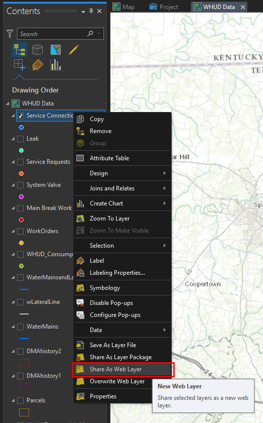
Both strategies will allow your data to be consumed in Insights, but for related data and projects with many layers it may be beneficial to publish them out as a single or a couple of services. This will cut down on your service load and make the backend administration a little bit more manageable.
What about Non-Spatial Data?
Along with consuming your spatial and enterprise GIS data, Insights can consume non-spatial data as well. There are several ways you can get this non-spatial data into Insights, some are appropriate for ad hoc analysis while others are more appropriate for long-term projects or analysis.
- Feature tables in Portal for ArcGIS hosted feature services.
- Microsoft Excel files loaded into Insights through the Add Data Dialog.
- Connecting to another database though the included database connectors which currently support Microsoft SQL Server, SAP HANA, and Teradata.
Choosing which type of connection to use is important and the tips below can help you determine which is the best choice.
- If your data already exists as a table in a SDE or FGDB then publish it out as a feature table to Portal.
- If the data exists in one of the mentioned database systems consume it directly from that database.
- If you have Excel data that you want to use on an ad hoc basis, for testing reasons, or for a simple analysis just drag the file or brows to it in the Excel tab of the add data dialog.
- If you would like to use Excel data in a project that you will update frequently, will be long in duration, or will require many analysis and calculation tasks it is best to load the Excel file into a database or convert it to a feature table.
Following these guidelines should make working with your data much easier in Insights, and will take a lot of the guesswork out of any trouble shooting that may be data related.
Accessing the Living Atlas in Insights
Along with accessing your organizations data in Insights you also have access to all the content contained in the Living Atlas. The Living Atlas is the foremost collection of global geographic information, it is curated by Esri with contributions from both its partner and user communities.
There are two main ways to access data from the Living Atlas in Insights.
- Loading base geographies from the Living Atlas (US Counties, Parks, Census Boundaries, etc.) into your Insights page.
- Enriching your own layers with data from the living atlas (Census Data, Spending Habits, Income Data, etc.).
There are dozens of geographies available for you to access and more than 700 variables for use in enrichment.
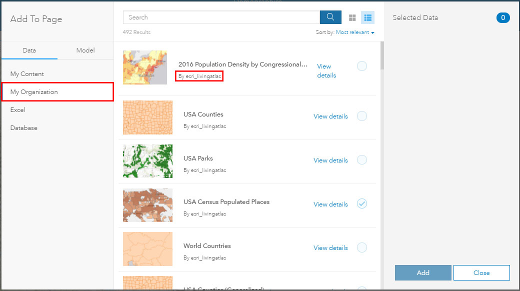
To add Geographies simply click on the Add Data button and select “My Organization” from the list of data sources, this will show all the Living Atlas geographies available to your organization (they will be authored by “esri_livingatlas”).
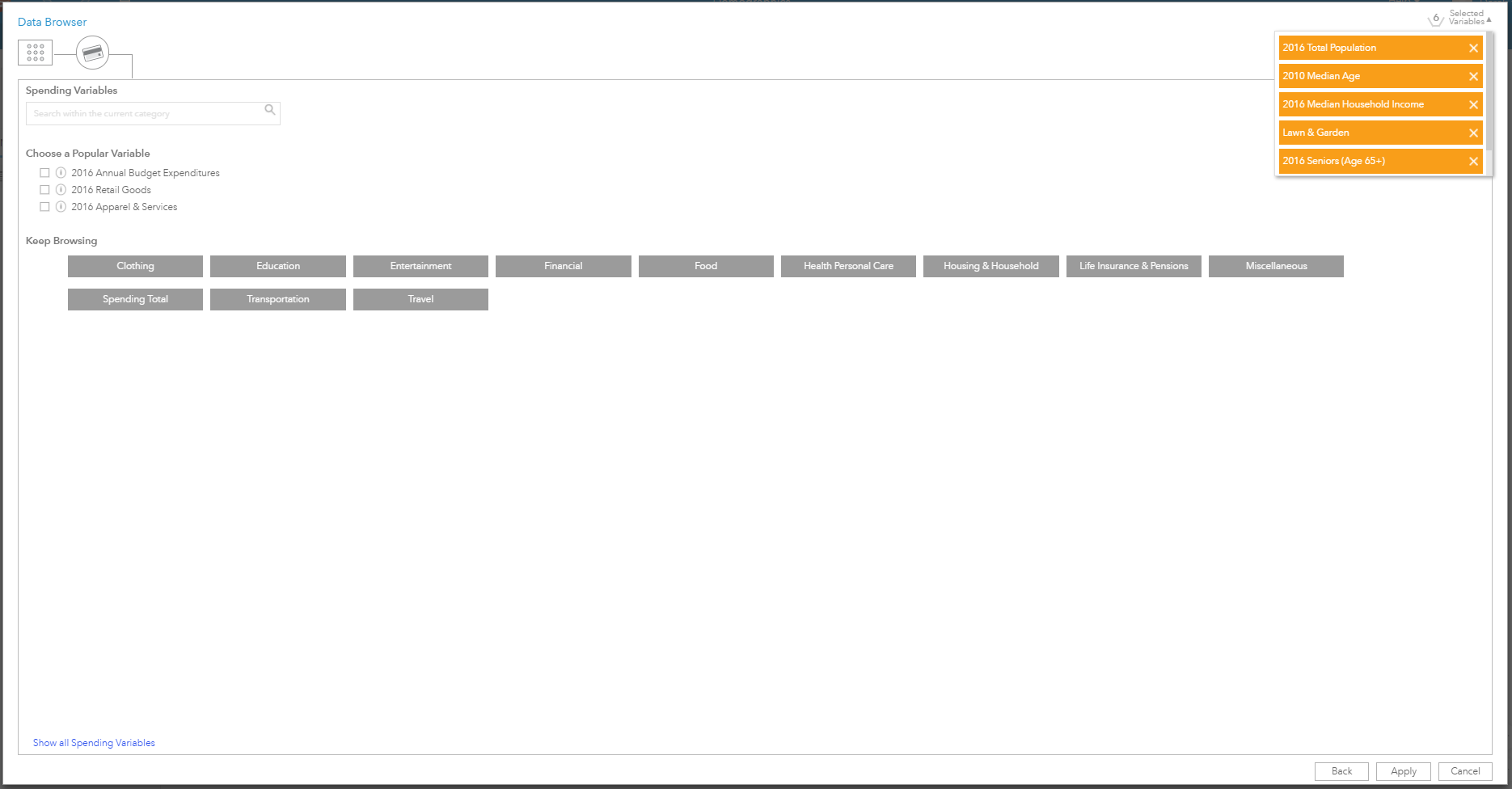
To enrich your data with information from the living atlas first click on the Action Button and select the “Enrich Data” tool, select the layer you would like to enrich and open the data browser. In the data browser, you can navigate to one or many of the variables you would like to append to your dataset. Spend some time exploring the data browser to get an idea of the depth of data available. One of the most common datasets we used in our forums were focused on consumer spending habits to identify areas where residents may be amenable to rebate programs for appliances and reduction of irrigated land. Once you have selected the variables you are interested in click the apply button and the variables will be appended onto the dataset you selected to be enriched. From that point, you can create rich maps with this data or analyze it using the tools available in Insights.
Insights for ArcGIS allows you to access your data from many different locations, it allows you to take data from disparate business systems and easily combine them together to perform powerful analysis. Insights also gives you the ability to easily reach out and grab hundreds of demographic variables that can help your organization make better decisions and improve how you serve your customers. Check out the story maps here to see what other water utilities are doing with Insights for ArcGIS.
Want some help getting started, see our Getting Started with Insights training class or brush up on Insights tips and tricks.
This is a genius idea John. So simple but so powerful. Great work
Wow, thanks! It’s amazing what you can do with blend modes and some time dedicated to completely goofing off.