What helps you model complex parameters such as live traffic, trucking speed limits, and now maximum vehicle speed, all within the same route? The answer is ArcGIS Online!
Many vehicles cannot exceed a certain speed. This could be a manufacturer’s limitation or a certain organization’s max-speed policy enforced by a governing mechanism on board the vehicle. In the past, the inability to accurately model maximum speeds made it difficult to provide accurate arrival times and perform efficient route planning. But not anymore.
ArcGIS Online now allows you to define your vehicle’s maximum speed. This max speed is represented within a travel mode. Once an administrator configures the travel mode, the analysts can then use that travel mode in route calculations. Let me explain it to you in detail…
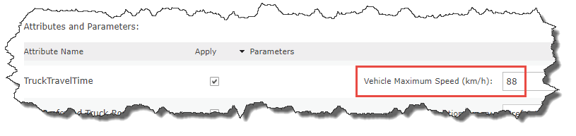
First, create a new travel mode in your organization. To do this, you must be an administrator of your organization. Details are in the travel mode help documentation. In the example below, we’ve chosen to make a copy of the Trucking Time travel mode. In your travel mode, under “Attributes and Parameters”, there is a new parameter on TruckTravelTime for the Vehicle Maximum Speed (km/h). By default, this value is set to zero, meaning that there is no maximum speed specified. In the image below, we’ve updated the parameter to be 88 km/h (which is equivalent to 55 mi/h). After updating this value, save your travel mode.
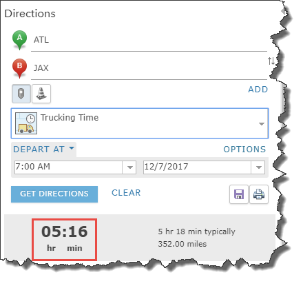
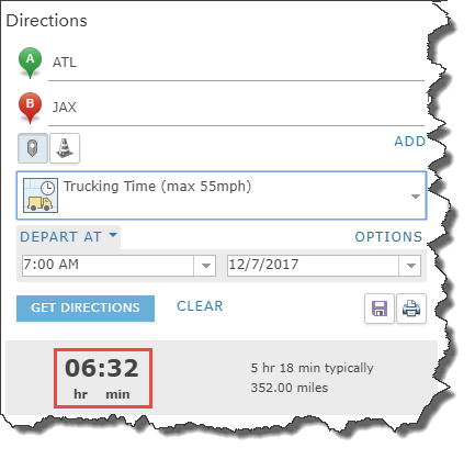
Next, test your travel mode. In the Map Viewer, open the Directions pane. Use the Trucking Time travel mode to create a route, from ATL airport to JAX airport. Solve it with the original Trucking Time travel mode, and then with the newly created travel mode with the maximum speed. Notice how the total times vary. In this case, it’s a difference of 76 minutes! With the vehicle maximum speed set to 88 km/h it takes about 6 hours 32 min, whereas if this isn’t specified it takes 5 hours 16 min.
At Esri, we are committed to deliver the most innovative solutions to help you succeed. And with our continuous advancements in ArcGIS Online, we are making sure you can solve complex problems with ease. So, keep on trucking, and let us know of any feedback!

Article Discussion: