Checkout our new product logo? Pretty snazzy eh? The new icon reflects the idea of a moving gear, the 3 shapes that surround the central white hexagon gives a sense of rotational movement and their protruding ends appear to extend a bit from the central shape like gear teeth. We feel this promotes the concept of a spinning ‘widget’ that powers your web apps built on Web AppBuilder for ArcGIS.
Pop culture side note: The logo’s gear teeth when connected to other gears creates motion, which, when arranged in a certain way resembles a “fidget spinner”. FYI “fidget spinners” are trending and very popular right now (those of you with kids will know what we’re talking about).
 Let’s checkout what’s new in this “summer 2017” update.
8 new widgets
This release includes 8 new core widgets, which provides some great new functionality in Web AppBuilder. Several were contributed by the Esri Solutions Team – so you may already be familiar with some of these capabilities.
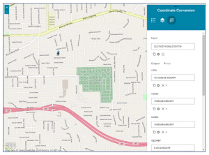
- Coordinate Conversion widget– This widget enables you to input coordinates using one coordinate system and output to different coordinate systems using multiple notation formats. These include:
– Degree-based formats (DDM, DMS, and DD)
– Global Area Reference System (GARS)
– Military Grid Reference System (MGRS)
– United States National Grid (USNG)
– Universal Transverse Mercator (UTM)
– World Geographic Reference System (GEOREF)
Simply click a location on the map and its spatial coordinates will display in the coordinate systems selected in the widget.
- Full screen widget – This enables web apps to launch in full screen mode in your web browser.
- Grid Overlay widget – This will render and display a US Military Grid Reference System (MGRS) grid dynamically and at different index levels inside the application based on the scale of the map display. FYI, MGRS is an alpha-numeric system, based upon the Universal Transverse Mercator (UTM) and Universal Polar Stereographic map projections, for identifying positions. You can configure properties of the grid appearance such as line color, spacing, and label font size at each unique index scale.
- Infographic widget– This widget includes 8 graphic templates to visualize and monitor attributes and statistical data. Think of this as an enhanced charting widget for data visualization. You can use a graphic template to visualize field values, field statistics, or feature counts. The 8 graphic templates are: number, gauge, vertical gauge, horizontal gauge, pie chart, column chart, bar chart and line chart.

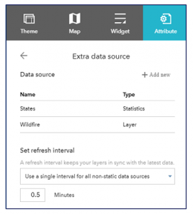
The widget’s visualization graph is dynamic and refreshes whenever the map extent or data source changes, and is interactive with the map. The widget supports two data sources: feature layers in the map with query capabilities and additional data sources (e.g., an output layer from another widget, such as the Query widget or Geoprocessing widget; or a data source specified on the Attributes tab in the Web AppBuilder builder environment).
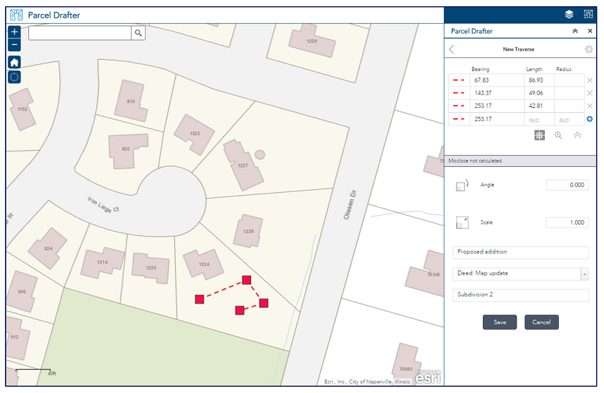
- Parcel Drafter widget – This widget is meant for precision parcel editing by entering metes and bounds descriptions and checking for closure errors. It can be used by mapping technicians in Assessor Offices and Register of Deeds in local governments to verify deeds and land record documents. It can also be used by surveyors and title companies to verify survey information prior to submitting their documents to those offices. Learn more about this widget here.

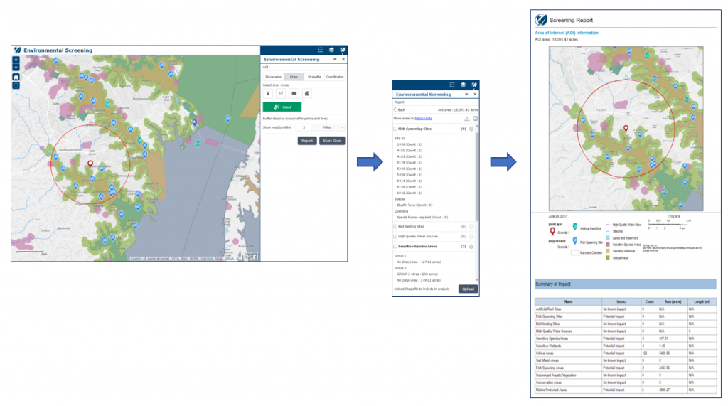
- Screening widget– Enables you to define an area of interest (based on a placename and buffer distance; drawing a point, line, or polygon; an input shapefile that defines the spatial extent; or a coordinate location and buffer distance) and analyze specified layers for potential impacts. For example, the environmental impact of a proposed new development project. After defining the area of interest, the widget will analyze its effect on the specified layers, based on the amount of overlap. It reports results of the analysis by summarizing a count of intersecting features and length or area of overlap. The analysis results can be shared with others as a printed report, CSV file, and file geodatabase or shapefile download. Learn more about this widget here.
- Suitability Modeler– This widget helps you find the best location for an activity, predict susceptibility to risk, or identify where something is likely to occur. It allows you to combine and weight different input layers so you can evaluate multiple factors at once. For example, you can use this widget to determine the optimal locations for a new commercial development property.This widget uses fast, web-based Weighted Raster Overlay (WRO) to generate models from a service. You can start from a blank state of a WRO service or a pre-configured WRO model. (FYI: Esri provides several Weighted Overlay Services in ArcGIS Online that are publicly available. These include: World Ecophysiographic, USA Landscape, and Green Infrastructure Suitability – all of these services have global coverage.) Choose layers, assign weights and adjust layer classification values to define your analysis. Then run the modeler, visualize results, and optionally save the result as an item in your ArcGIS organization. Learn more about this widget here.

One new widget was added for 3D web apps,
- Basemap Gallery (3D) widget – This widget displays a collection images representing basemaps from your organization or a user-defined set of map or image services.
New Dashboard theme
The new theme displays all the widgets in the panel simultaneously when the app starts. It is designed to visualize widgets and their communication directly. You can modify the predefined layout by adding, removing, or resizing the grids in the panel. By default, most on-screen widgets are turned off except for the Home and Zoom Slider widgets. Optionally, you can turn on the Header widget to display the logo, the app name, and links.
Widget Enhancements
- The Basemap Gallery widget in 2D and 3D apps now supports vector tile basemaps.
- The Group Filter widget has a “Persist after widget is closed” option so its filter still applies in the app after the widget is closed.
- The Edit and Smart Editor widgets now have support for organization members to edit public feature services regardless of their edit privileges.
- The Info Summary widget supports showing all features rather than filtering by extent, alphabetizing list content, expanding the first layer in the widget when it is first accessed, and improved handling for filtered layers. The widget panel will also now be sized to fit the list content.
- The Situation Awareness widget supports sharing analysis results via printed report, sharing snapshots into a selected group, and has improved handing for layer visibility and services using subtypes.
- The Smart Editor widget now supports automatically saving edits so you can quickly digitize new features. It also enables geometry edits by default so you can quickly modify the shape of a feature.
- The Time Slider widget has an improved user interface and user experience.
General Enhancements
- In the Builder, the Attribute tab has a new option to reference additional data sources that can be shared at the app level, so all widgets in the app can quickly access and respond to it simultaneously.

- In the Builder, the Map tab has an option to set the refresh interval in sync with the latest data.
- Web AppBuilder now partially supports the Shared Theme that is defined in your ArcGIS organization. Supported items include: logo, logo link, and header color for text and background.
- You can create 3D apps from the Share dialog in the Scene Viewer.
We hope you enjoy these new enhancements to Web AppBuilder and see you at the Esri UC!!
Sincerely,
The Web AppBuilder for ArcGIS Dev team


Article Discussion: