I asked Jay Theodore, ArcGIS Enterprise CTO, to share the platform vision for the enterprise. He wanted to highlight three key themes for our latest release:
ArcGIS Enterprise 10.5 is a full-featured mapping and analytics platform for organizing and sharing your maps, 3D scenes, apps, analytics, web services, and data. It improves your efficiency, collaboration, and communication by connecting people, processes, things and data.
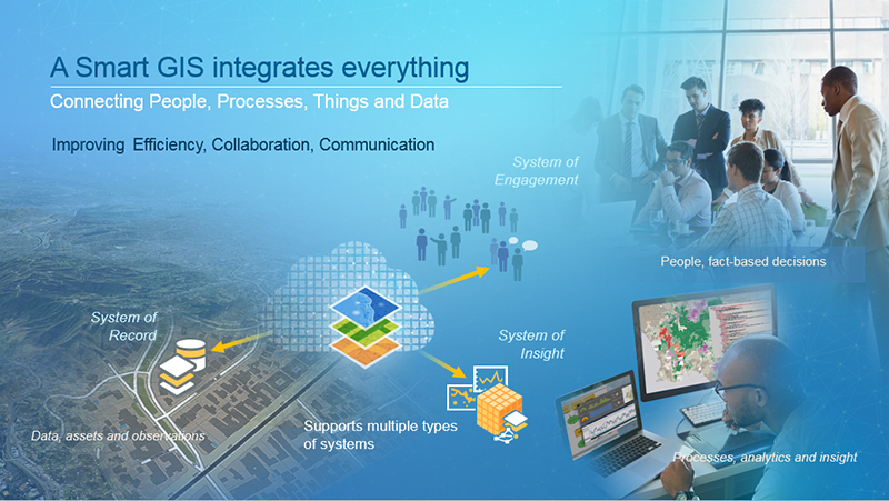
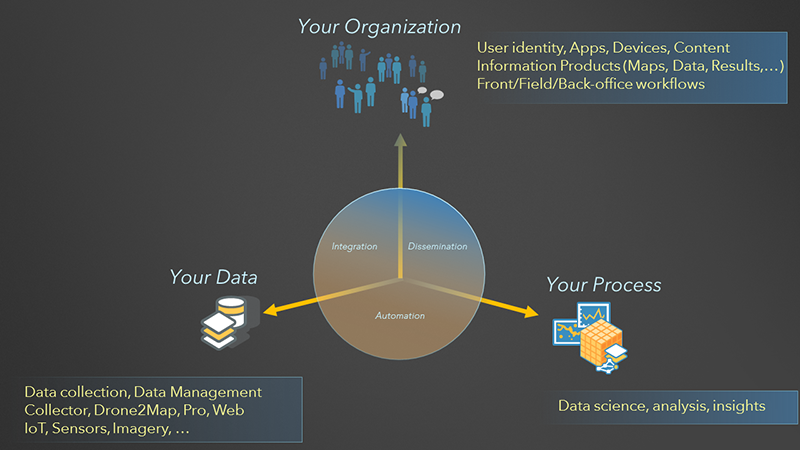
ArcGIS Enterprise comes with all the necessary geospatial infrastructure components to handle various existing and new workloads. These software components—a portal, servers, data stores, and a web adaptor—enable you to deploy an integrated system of engagement, record, and insight to meet your organization’s needs. And by taking advantage of new analytics, automation, and distributed GIS capabilities introduced with ArcGIS Enterprise 10.5, your systems can come alive in ways never before possible.
Integrated system of systems
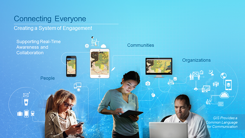
A system of engagement is created from ArcGIS Enterprise 10.5 portal where members of your organization are enabled to discover, use, and share authoritative and curated content. Your users have roles and specific privileges for interacting with information products and apps that are centralized and hosted in the portal. The portal apps are modern, focused and ready to use in the back office, front office, in the field, and with the community. In addition, you have access to a suite of customization options including templates, app builders, and APIs. Your portal also includes Esri-curated content from Living Atlas of the World.
Your system of record is supported through your ArcGIS servers. ArcGIS servers support various workflows around your data like data collection, management, editing, visualization, and querying. The data can be attached to the system as part of an integrated enterprise data store—for example an enterprise geodatabase within Oracle, SQL Server, PostgreSQL, or DB2—or poured into the system as part of a self-service mapping workflow and stored in the appropriate built-in data store. This system can also append real-time observation data in data collection scenarios that complements your records. A kind of system of “observation” comes alive with Internet of Things (IoT) real-time data streams ingested through GeoEvent Server and Drone2Map for ArcGIS. ArcGIS Pro, the professional GIS application in your back office, supports workflows around this system of record.
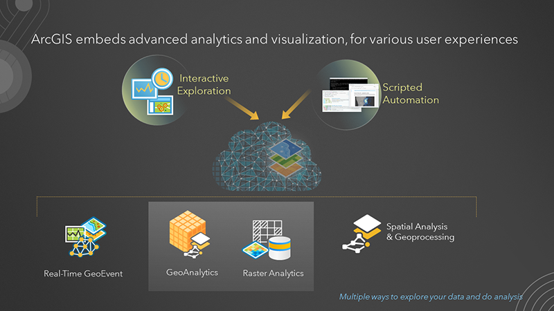
Your system of insight has always included geoprocessing and spatial analytics capabilities of the ArcGIS platform. Starting at 10.5, it can now also include the new GeoAnalytics Server for running big data analytics, the new Image Server’s raster analytics capabilities, new Insights for ArcGIS app, GeoEvent Server for real-time GIS, and Business Analyst Server for demographic mapping and analysis. This system reflects your business process and allows you to find answers, by analyzing your data and helping your organization make data-driven decisions, in a timely manner. You can interact with this system interactively though native experiences within apps including ArcGIS Pro or automated and scripted using the ArcGIS API for Python.
1. Analytics
ArcGIS Enterprise 10.5 introduces purpose-built servers that are designed for highly scalable and performant analytics and various user experiences for exploring data and solving spatial problems. Your analysis execution is now parallelized across a distributed computing and storage infrastructure. The data to these analytic servers can be in many formats and representations including raster imagery, big data stores, and streaming real-time feeds. Use ArcGIS Pro and the new Insights for ArcGIS app to perform advanced algorithmic spatial analysis with intuitive user interfaces. For automated analytics, use the new ArcGIS API for Python.
2. Automation
The need to automate has always existed to improve efficiency but now it’s become critical for business operations to meet their service level agreement needs. Automation has also become critical to scale on demand, driven by the volume of data generated from IoT and the data-driven decisions that need to be made where a timely answer, based on every data point available matters, including data that just arrived a few minutes ago. ArcGIS Enterprise enables you to automate your entire system of systems, from initial deployment to various user workflows. It simplifies DevOps, whether you choose to deploy in your own data center or a public cloud infrastructure, and includes useful new automated deployment resources like ArcGIS Chef Cookbooks, ArcGIS Enterprise Cloud Builder for Microsoft Azure, AWS CloudFormation templates, and ArcGIS API for Python.
3. Distributed GIS
The system of engagement needs to be able to reflect your organization’s structure and help you achieve your organizational goals through well-defined collaboration workflows. ArcGIS Enterprise enables a new type of collaboration that connects individuals, organizations, and communities to the right data at the right time.
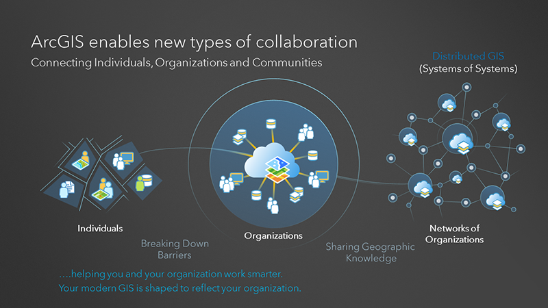
We live in a connected world where data-driven decisions are becoming more common. Citizens are demanding the democratization of data that helps build smarter organizations and businesses. But organizations that are distributed and have partitioned their data can be challenged to provide the right kind of data, with the right access permission, at the right time. Distributed Collaboration helps organizations organize and work with distributed data and information products. It builds trust and enables collaboration across organizational boundaries, when necessary and possible. Internal-only, compartmentalized assets are kept closed, when required. It helps your organization work smarter. Collaboration enables enterprises to create this organizational network, to enable a distributed system of engagement where multiple systems can now access information products and data from the source of truth, in a live and secured manner.
ArcGIS Enterprise 10.5 is a significant release with major advancements in mapping, analytics, collaboration, and automation. It redefines what’s possible for delivering timely, data-driven decisions.
For more details about ArcGIS Enterprise, watch the latest on Analytics, Automation, and Distributed GIS. And stay tuned for upcoming blogs about getting started with and leveraging ArcGIS Enterprise capabilities in your organization.


Article Discussion: