The ArcGIS API for Python is releasing version 2.0 in February 2022. The release will focus on performance and security improvements, framework and UX upgrades, new modules, and removal of deprecated functionality. While the major version is incremented to 2.0, the API remains fully backwards compatible, meaning your existing notebooks and scripts will continue to work after the upgrade.
Optimization and performance improvements
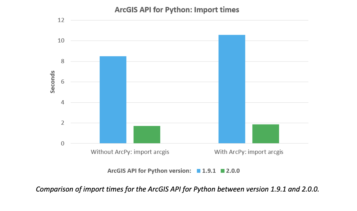
In version 2.0, ArcGIS API for Python users will observe several performance improvements including much quicker import times for the API itself. These improvements have required careful engineering and refactoring of the internal components of the API, keeping it speedy and agile for users as it continues to grow in size and scope.
Framework and UX upgrades
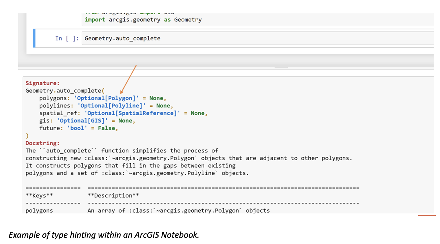
The ArcGIS API for Python 2.0 release will also add support for the new Python 3.9 version and will drop support for Python 3.6 and earlier. The latest release will introduce type hinting to several of the new public methods and functions we are adding, and we’ll continue to add this functionality to the remainder of the API modules in subsequent releases. Type hints allow users to know the data types of input parameters and return values for a function. These can help catch and debug errors, improve documentation, and make code cleaner and more understandable—all of which lead to a better user experience and more predictable behavior within the API. By adding type hinting to the API now, we expect to continue to improve its performance, especially as future versions of Python itself grow and improve.
Introduce new functionality and drop deprecated features
While 2.0 revamps a lot of back-end, framework-level components of the API, certain new features will also be added to the API. We have renamed certain existing modules to increase their discoverability. The new naming convention will align with the current ArcGIS terminology and make them more identifiable by the problem they solve.
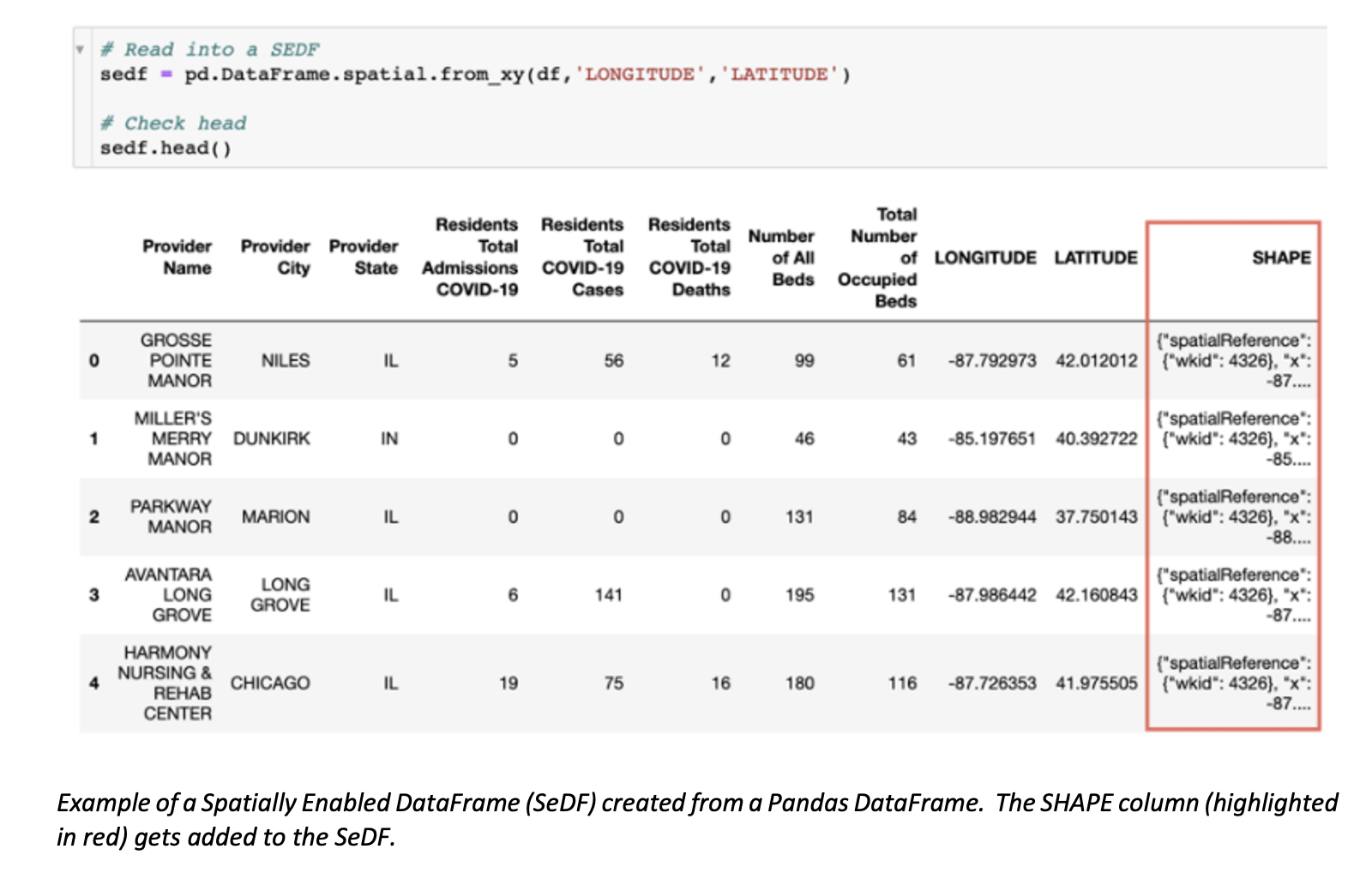
The 2.0 version of the API will also drop deprecated features. The most notable of these features is the SpatialDataFrame (SDF), which has been deprecated since version 1.5, and is now fully replaced by the Spatially Enabled DataFrame (SeDF). The SeDF provides better memory management, greater ability to handle large datasets, and is the pattern that the Pandas library advocates as the path forward.
Note: As part of the back-end work done to improve security in version 2.0 of the API, there is a necessary minor change in the token-based authentication process. As such, customers who use the ArcGIS API for Python to manage ArcGIS Survey123 should wait to upgrade to version 2.0 until the 3.14 release of Survey123 (mid-February 2022), as this new authentication procedure will not be available in Survey123 until this time.
Ready to give these capabilities a try?
Check out these resources to get you started:


Will the ArcGIS Pro package manager support this upgrade (and any dependencies)? Alternatively, will upgrading the package (via Pip/cmd line) in a cloned ArcGIS environment be successful?
We have seen this in the past that while a new version of the API is released, it is essentially unavailable for use if using an environment with the current release of Pro. This is in fact documented with support services. It would be helpful (and transparent) to show what API releases are viable with versions of Pro.
Zachary – thanks so much for the question. Here is the recommended way to do this upgrade. First, clone your ArcGIS Pro env, then go to command line and use:
The ArcGIS Pro Python env is “pinned” to the minor version of every Python package (the middle number of the package) version, so to bump up to the major version you have to include this “–no-pin” snippet. That should do the upgrade and include the dependencies.
Regarding the Python API release cadence with Pro, check out the schedule on our public github repo.
https://github.com/Esri/arcgis-python-api/wiki/Python-API-release-dates-and-runtimes
thanks Nicholas! Support Services was unable to provide me with the release document for a somewhat recent upgrade issue. Thanks for providing this, very helpful!
Nick — what about upgrading the arcgis framework in an ArcGIS Server 10.9.1 installation? I’m thinking of workflows like publishing tools from PYT toolboxes in Pro 2.9 as GP services
Thanks!
UPDATE: Never mind, just found the AGS documentation for this (https://enterprise.arcgis.com/en/server/latest/publish-services/windows/deploying-custom-python-packages.htm)
It would be nice if the info about updating Pro and installation were linked from the “Install and setup” page of the ArcGIS API for Python guide on developers.arcgis.com/python!
Jeff – thanks for the note. It looks like you figured it out. When you suggest linking the Pro doc to the “Install and Set Up page”of Python API, which link exactly were you referring to? thanks!