This update has many new and exciting features – many have been requested many times from our users. We’ve listened to the Web AppBuilder user community feedback and we’re pleased to announce the following new enhancements to Web AppBuilder:
7 New widgets
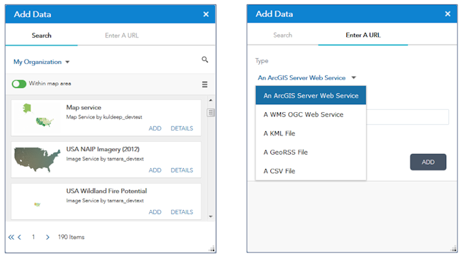
▪ Add Data widget – Enables you to search for layers in ArcGIS Online and add them to the map. You can also add ArcGIS Server web services, WMS OGC web services, KML, GeoRSS, and CSV data layers by specifying their URLs.
 ▪ Filter widget – Enables you to filter features based on an expression. Other widgets will honor the filter settings if applicable.
▪ Group filter widget – Enables you to apply a filter (based on an expression) on the map based on one or more layers. You can define a set of layers in the map as a logical set, then apply a filter on them. This widget makes it easy to quickly filter out data from multiple data layers based on a common criteria.
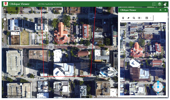
▪ Oblique viewer widget – Displays images in their native coordinate system which avoids distortions caused by projecting them to a geographic coordinate system or projected coordinate system. It enables end you to pan around in the oblique mode, in a single viewing angle, or switch angles to view an area of interest from different angles.
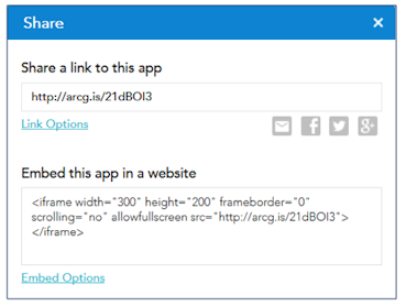
▪ Share widget – Enables you to easily share your web app in a link within an email, to various social media such as FaceBook and Twitter, and embed within a website. You can also define URL parameters easily.
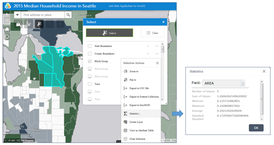
▪ Select widget – Enables you to interactively select features on the map, then perform a selection action such as: calculate statistics based on a field, create new layer, export to CSV, feature collection, and GeoJSON. For developers, this widget is a good example that demonstrates inter-widget communication as selected features from this widget can be passed as input into other widgets, such as the Geoprocessing widget.
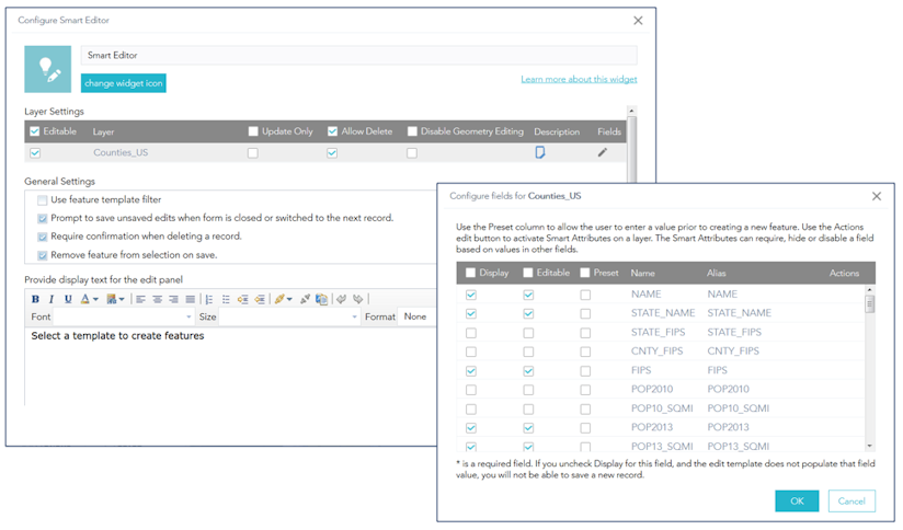
▪ Smart Editor widget – This widget extends the core editing widget with the following features:
- Smart attributes: attributes can be hidden, required, or disabled based on the values of other fields
- Edits not saved until user clicks save and records are validated
- Ability to view pop ups from other data while in “edit session”
- Ability to preset field values across many fields on many layers and apply them to every new feature
- Ability to edit a series of features
- Option to move or modify existing geometry
- Only changed records are submitted to service, not the entire record
- Option to update a feature attribute only
- UX that allows you to edit attributes in the same panel as feature templates and you can freely explore the map while editing
Enhancements to existing widgets
Many existing widgets have also been enhanced for improved usability and better support web app workflows.
▪ Query widget – Supports spatial relationships such as intersect, overlap, and contain, so you can perform a query with features in a different layer. We made the following UX improvements: now you can perform a query with fewer clicks:
– When only one query is configured, clicking the widget will automatically execute the query (no need to start from the task list page);
– When a query does not require any inputs, clicking the task item will automatically execute the query.
▪ Attribute Table widget – Selecting records in the table will highlight their features on the map and vice-versa.
▪ Layer List widget – Enables you to choose which layers you want to show on the list. You can also control the visibility of all the layers.
▪ Edit widget – Supports filtering on feature templates and tolerance settings.
▪ Geoprocessing widget – Supports a set of features as input from a layer, a popup, Query, and Select widget.
▪ Near Me widget – Enhanced with additional configuration parameters including the ability to display the buffer on the map, return intersecting polygons instead of buffered polygons, and zoom to the selected features instead of the buffer.
▪ District Lookup widget – Supports stacked polygons.
▪ Related Table Charts widget – Supports polar charts.
▪ Info Summary widget – Is now out of beta and fully supported.
▪ 3DFx widget – Now supports 5 different 3D-animation approaches to visualize and analyze geographic information in an intuitive and interactive 3D environment. These include:
- Point Extrusion – Uses cylinders to display a point feature layer.
- Pulse – Uses circles to display a point feature layer.
- Bounce – Uses glowing balls on top of dash lines to display a point feature layer.
- Fireball – Uses flying glowing balls to display a polyline feature layer.
- Jet Trail – Uses flying glowing balls with tails to display a polyline feature layer.
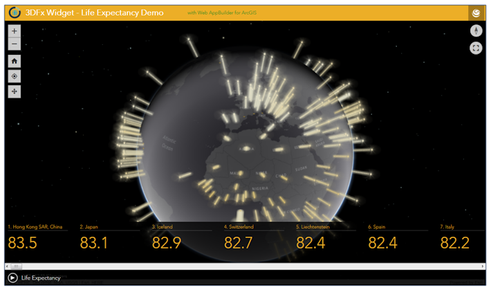
Click the image above to see a live demo of the 3DFx widget!
Other enhancements
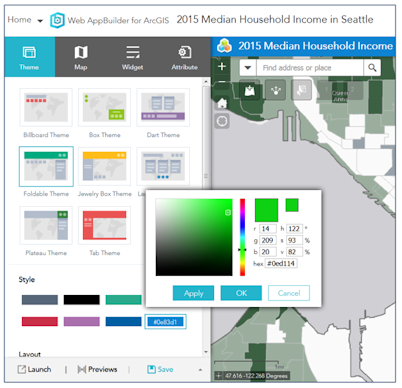
▪ Theme tab – For the style, a color picker option is now available where you can choose your own custom color and/or input RGB values.
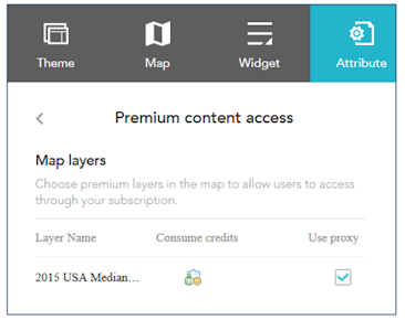
▪ Attribute tab – Includes options for setting custom fonts for the app’s title and subtitle, improved UX for adding links, and a new option for configuring Premium content from ArcGIS Online (e.g., you can enable Premium services to be accessed in a public facing app).
Sincerely,
The Web AppBuilder for ArcGIS Dev team

Article Discussion: