 The astrological sign for people who are born in September is Virgo – the 6th sign in the zodiac. Virgos are typically known to be analytical, kind, hardworking and practical. They also like to do detailed work and want to improve things. With this September update, the main theme was to improve the user experience for several popular widgets based on feedback from the Web AppBuilder user community. Like Virgos, we are always striving to make things better in Web AppBuilder.
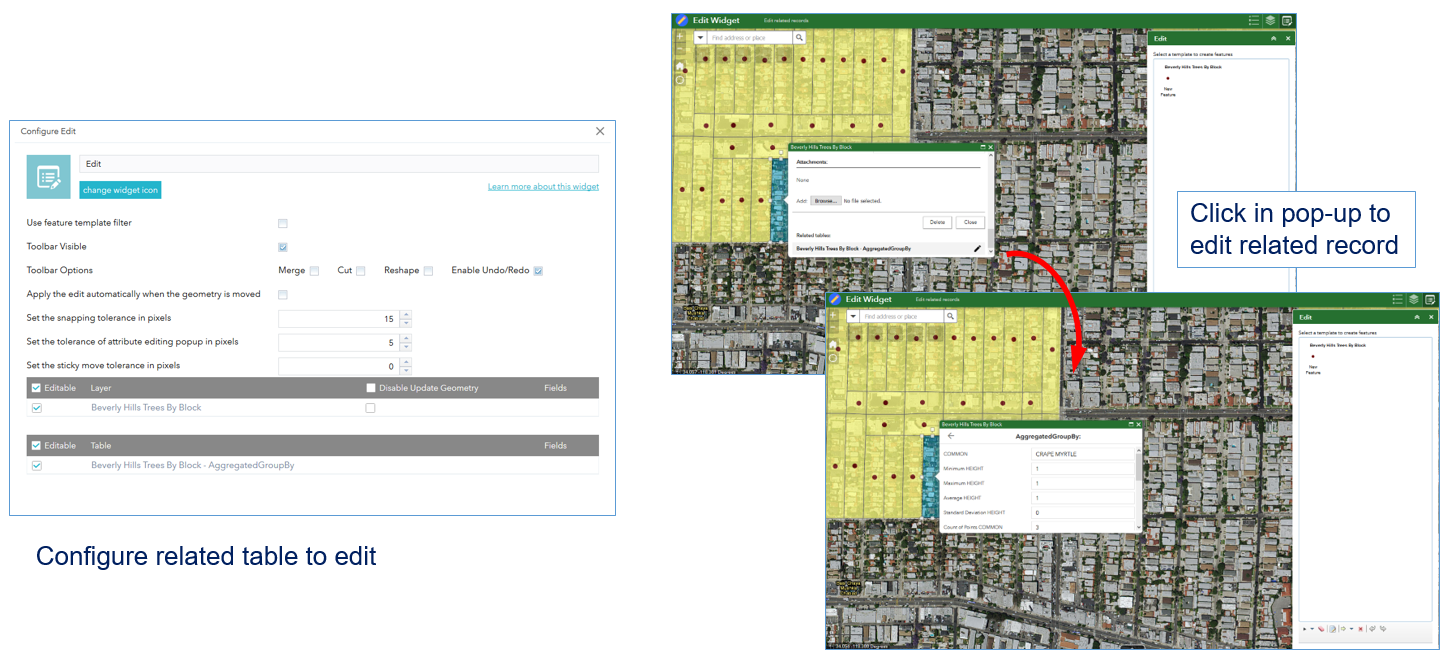
Edit widget – The biggest enhancement is the much requested ability to edit related records with the Edit widget. When feature layers with related tables are accessed, you have the option to enable editing on the related tables when configuring the widget. The widget supports editing from origin to destination tables for “one-to-one” and “one-to-many” relationships.
Filter and Group Filter widgets – Both of these widgets now include the option to remove any preset filters that were defined in the web map. This may be useful in cases where you access a web map that shows a specific data subset. For example, a web map that only displays cities with populations of 100,000 or less; but it uses a web service that contains cities with greater populations. By removing any filters set in the web map, you can now work with all of its data. Continuing the example, when web map filters are removed, it allows you to access all cities, even those with populations above 100,000. You could then apply your own filters to the data, based on the entire dataset.
Filter and Query widgets – Both of these widgets now support filtering unique values based on previous expressions, if the widget has more than one expression. As you enter criteria for the first expression, the widget begins to generate a subset of results, then as you input the criteria for the second expression, it will only be applied on the previously returned subset. This greatly improves the user experience for both these widgets, because it reduces the number of returned results even before you execute the filter or query.
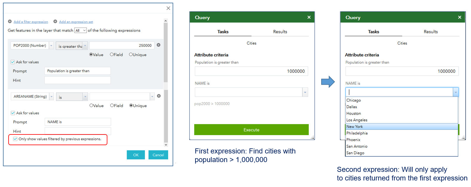 In the figure above, a Query widget is configured on the Cities layer with two expressions. The first finds cities with populations greater than 250,000 (by default); the second searches for a specific city by name. In the center graphic, when the expression to find cities with populations greater than 1,000,000 is entered into the Query widget, the second expression will only be applied to the results subset returned by the first expression. In other words, only cities with a population greater than 1,000,000 will appear in the dropdown list of the second expression. Once both expressions are filled in, you can run the query.
Near Me widget – Its user experience has been improved: layers with zero results returned will no longer be displayed in the results list. We’ve also reduced the number of clicks to view returned results.
Search widget – A new option called “local search” enables you to set a minimum map scale for the widget. It is meant to work with the Esri World Locator service. When you perform a geocode search, returned results are ranked based on how closely they match the geocode request. You can now control the threshold map scale that helps to prioritize the returned results.
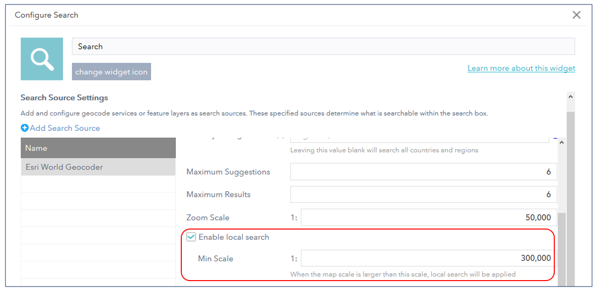 For example, when the map display zooms to a map scale that is equal to or greater than the minimum scale (in this case 1:300,000), then the results of the geocode will prioritize (and therefore give a higher ranking) to returned results for features that are within the minimum map scale. This is useful for when you want the search to occur within a smaller area. This option is disabled for custom locator services.
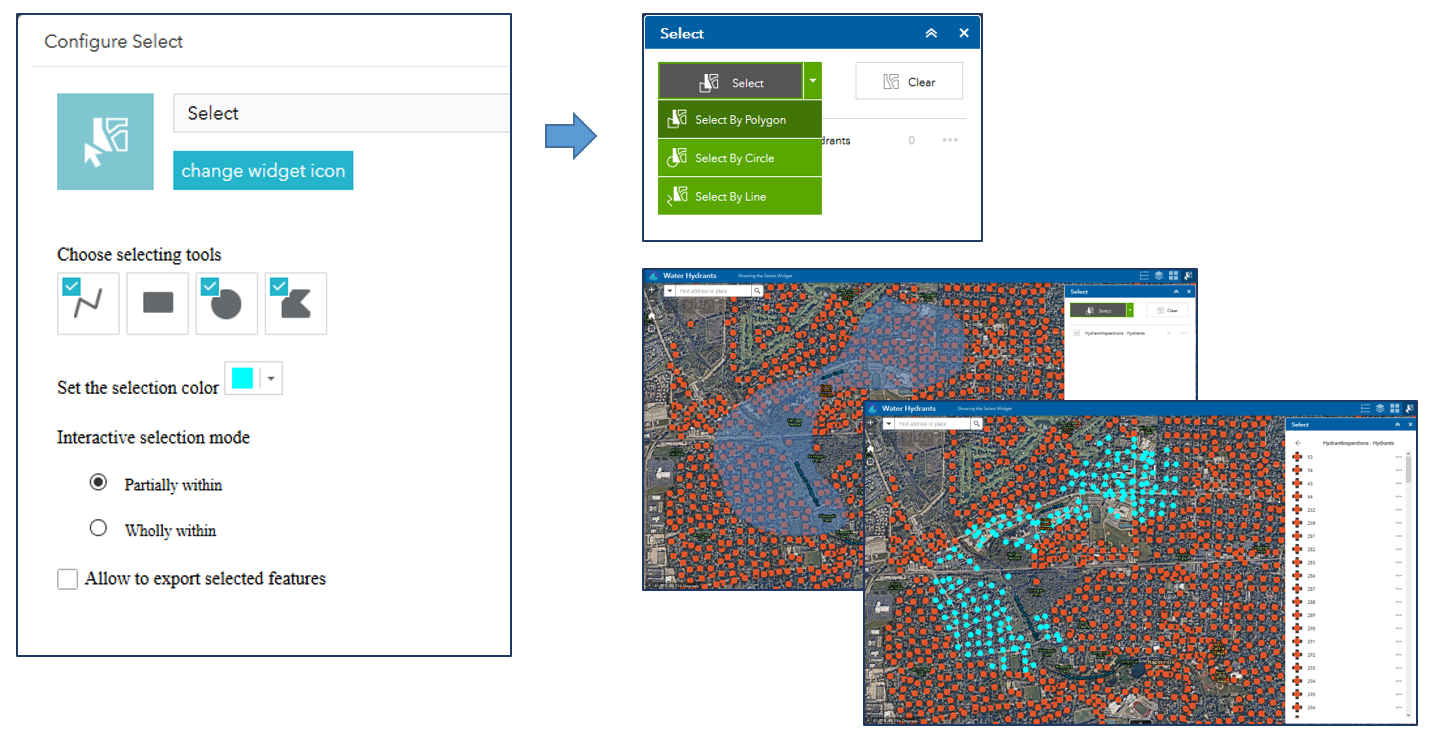
Select widget – Based on many user requests, we have added more feature selection tools. Now you can select features with a polyline, polygon, and a circle in addition to the rectangle select tool.
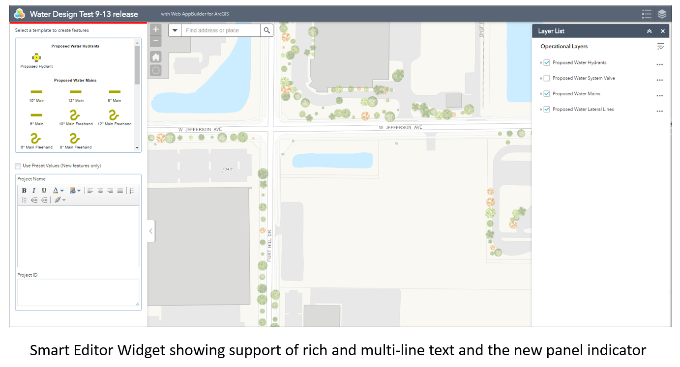
 Smart Editor widget – Some enhancements include: the option to restrict editing to just the feature owner; checks if the signed in user belongs to an editing role, if not the widget will be disabled; and the template picker is based on layer visibility.
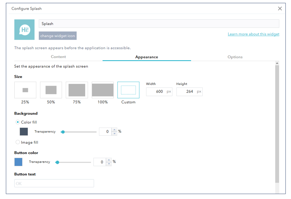
 Splash widget – Its configuration options have been extended to enable you to create more customized splash screen displays. More options for configuring the appearance include the ability to specify its size, background, transparency, button and text colors.
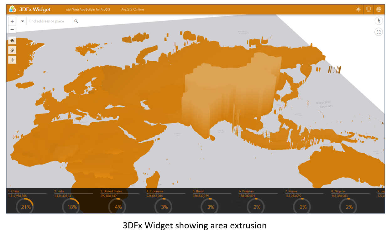
 For 3D web apps, the 3DFx widget has a new visualization type for area extrusions, which can provide some new unique visualizations. In the figure below, it shows world populations for each country. Currently, the visualization is limited to a single color, but we’re looking into extending the rendering capabilities of the 3DFx widget in a future release.
 Lastly, Web AppBuilder web apps now fully support ArcGIS Online groups with the update capability that enables its members to update all items in the group. This means that one or more group members can collaborate to create and modify web apps.
We think you’ll like many of these new features.
Sincerely,
The Web AppBuilder for ArcGIS Dev team

Article Discussion: