There are many ways to use ArcGIS Hub; organizations around the world have already enabled open data to launch ArcGIS Hub basic and create sites and pages. Others use our premium features to rally teams of collaborators around initiatives and events. No matter how you use ArcGIS Hub, we’ve put in work to improve how you, your teams, and your community search for and discover content that’s relevant to you. That’s why we’re happy to release enhancements to our search capability which has been in beta since the fall. Enhancements to this feature include support for more content types, private data, faster and more reliable indexing, a better search bar, and new ways to refine your search.
A smarter search bar
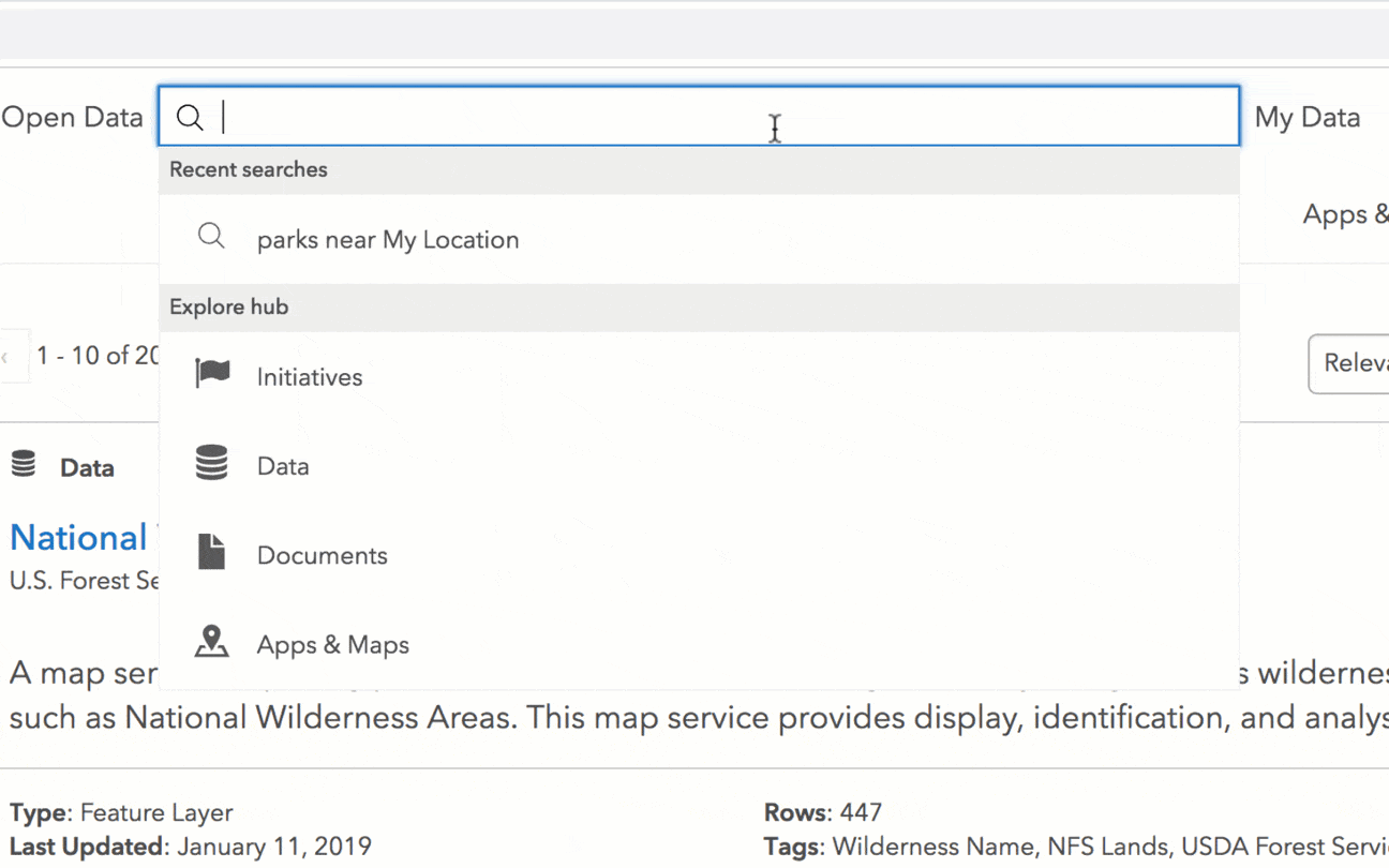
Thanks to semantics – logic that focuses on related words – you don’t need to know the lingo to get the most out of your search. Simply enter a keyword or phrase to start seeing results that match not only by title, description, or tag, but are related semantically. For example, a search for homes will also return results for property and parcels.
The search bar also features autocomplete to give you suggestions based on what you’re entering. Simply start typing a keyword to see suggested search queries.
See one you like? Click the suggestion to complete the search.
Once on the Search Results Page, term highlighting provides small visual cues to help you quickly identify what you’re interested in.
Each search result displays the collection to which it belongs, a description, and additional details .
New ways to refine your search
After something specific? The Search Results Page is where you can refine your search by collections and filters.
Select collections at the top of the page to refine your search by different types of content.
Initiatives- apps, sites, data, events, and other content that are organized around specific goals and projects.
Sites- websites for sharing data and content.
Events- opportunities for involvement that are part of an initiative.
Data- datasets, feature services, raster layers, etc.
Documents- Microsoft Excel and Powerpoint Documents, PDFs, document links, and iWork Keynotes and Pages.
Apps & Maps- map services, Operations Dashboard add-in, Web Map application, and more.
For more information on what kinds of data are supported in ArcGIS Hub, view our documentation.
Don’t have ArcGIS Hub premium features? No worries. Your collections won’t include Initiatives and Events but you’ll still have Sites, Data, Documents, Apps & Maps.
The top row of collections allows you to filter content by Data, Sites, Initiatives, Apps & Maps. Filters on the left side of your page the page refine your search by content type, capabilities, and more.
You can also use the filters on the left of the page to refine your search by capabilities, source, content type, or tags.
Capabilities- filter content that is available for download and/or has an API
Source-filter content by data publisher
Content Type- filter content by type, such as PDF or Web Map
Tags- filter content by tags.
Looking for all data or the most recent? You can also sort data based on Relevance, Most Recent, Trending, or Name.
More content types
We started by adding support for more content types, including initiatives, sites, pages, apps, and events. This means that no matter what you’re looking for, you’ll have access to all available content related to your search.
For example, if a local resident is curious about water quality in her community, a query for ‘water’ will return not only datasets and documents shared by local organizations, but initiatives, like water quality improvement plans, and events like stream clean-ups, for her to explore, learn more about, and get involved with.
Filtering data by collections shows you specific content, like Sites, Events, Apps and Maps related to your search query.
Access private items
While commonly used to share open data, ArcGIS Hub also enables you to share content privately within your team or organization. Whether you’re a volunteer who’s collaborating on an initiative that isn’t public yet, or you’re a staff member searching for a piece of internal data, find what you need under the Restricted filter. If you’re not already signed in, you’ll be prompted to log in, at which point you’ll be able to access data that’s been made available to you.
Private items can be accessed from the search result page by selecting Restricted at the top of your filter options.
Don’t worry about new or updated content. We’ve got it covered.
We want to make sure that any new content you add gets surfaced as soon as possible. That’s why we reengineered our index to be faster and more reliable, refreshing content at least every 24 hours.
We’ve also improved the date logic for content. If you made a change to a feature service that has edit tracking enabled, or if a Publication Date has been set in an ArcGIS Online item’s formal metadata, our search index will reflect these changes.
New to ArcGIS Hub? First, ensure that open data is enabled for your organization. Then, group together content that you want to share in an ArcGIS Online group that’s been enabled for open data. You’re ready to create your first site.
For more information on search collections and possible effects on your layout, check out this GeoNet post. As always, feel free to leave a comment or reach out to us with questions.
And don’t forget to stay up to date by following us on Twitter. and checking out our changelog for our release notes.
Tell us what you think
Have a minute? Take this brief survey to help us learn more about how we can connect organizations and their communities. We look forward to hearing from you.


Commenting is not enabled for this article.