
Esri is proud to offer a robust collection of online layers, maps, and apps that are actively maintained and regularly updated to support your work. As technology advances and data sources evolve, we’re focused on updating and streamlining our offerings to ensure you have access to the most current and optimized content.
As part of our commitment to always providing high-quality, performant, and relevant resources, we’re announcing the retirement of select legacy content in December 2025. This retirement date is important as select layers, maps, apps, and services, which have been in mature support for at least one year, will no longer be available to use after December 10th, 2025.
Retiring Items
Most of the items scheduled for retirement have been in mature support for over two years, and many have recommended replacements in their descriptions to help guide your transition. We recommend updating your maps and apps to discontinue use of the retiring item before our retirement date. Use the replacement item, when a replacement is available. Check out the complete December 2025 retirement list with more than 900 items listed.
Listed below are the top 50 most used items that are retiring in December.
| Retiring Item | Retiring Item Id | Replacement Item |
| 2021 USA Average Household Income | c4421bd4389a48aa930f0835c161b9a1 | |
| 2021 USA Diversity Index | 7590341d1d1d41a4a87ebc51d46d4cc4 | |
| 2021 USA Median Age | 9f55e7006a614e43b30642a0f9fc3266 | |
| 2021 USA Median Household Income | 39001018f2924cb5a7d4cd65932a9484 | |
| 2021 USA Population Density | a8407298de7e48078a2bc9cdd76c79af | |
| 2021 USA Tapestry Segmentation | 4bbba5f3ef5b40649ff7fc15f7a481b1 | |
| 2021-2026 USA Population Growth | 7996844858ec41b1a73836888e95ff30 | |
| 2022 USA Average Household Income | 702bd623b3614b4184f94947c18b75c8 | |
| 2022 USA Median Age | 5beee3b463ee470193c8f1d823fab026 | |
| 2022 USA Median Disposable Income | 706993115a5842f6b45d563d35a74109 | |
| 2022 USA Median Home Value | d878a91b201b401a94640400511a4f0e | |
| 2022 USA Median Household Income | 6f752f2f28404224b01a3e274d4ac48c | |
| 2022 USA Population Density | 9647e1c3791649cdbff698ef6fb8615c | |
| 2022 USA Retail Goods Spending | 98f1f847c5ea4f06a1ec07530efb3e49 | |
| 2022 USA Tapestry Segmentation | a5bc0c263b414192a816b41bab840864 | |
| 2022 USA Unemployment Rate | 9c1736494dda49799ac99e78780333f0 | |
| 2022-2027 USA Population Growth | 52bc80a9d2a14e5c9a4b08b91b52f84b | |
| Antarctic DEM: Aspect Degrees | 99eb277e37f648849de7eb116509b835 | c7146f29d7e54c8bb00a7ec7d8ea47b6 |
| Arctic DEM: Aspect Map | 7b37bb89034743019e09b0fae5c83ee3 | 4334ffd98a0a4be685f81157a6fbdeca |
| Arctic DEM: Hillshade Elevation Tinted | 96d57dae024c44209b76a1651c66e4b8 | 4334ffd98a0a4be685f81157a6fbdeca |
| Arctic DEM: Hillshade Multidirectional | b1d76f57cb4d444c8e41bf3dea4b5833 | 4334ffd98a0a4be685f81157a6fbdeca |
| Crime in the United States | 10ac47ab854b4d4c922b1c49b8630379 | |
| Europe NUTS 0 Demographics and Boundaries | bdcb40c0b6124f6d99f10b9b23647712 | 5dcc70713cba47838853e1576bcd890c |
| Europe NUTS 3 Demographics and Boundaries | 26820f941dac4b55afde2491d6abc568 | 5eb88decbff54520b49c785241c07bf4 |
| Italy Provincia Boundaries 2021 | 66901bc6e3f64215a771561a028510df | 5ac0f7517c094f5284035508d0bf6059 |
| Traffic Counts in the United States | ced1855778634da6b72516ec2f33b219 | |
| Ukraine Oblaste Boundaries 2021 | 8f97b6c2194341a8a420cb67df34db94 | e828321637244f55ae075f542a942900 |
| United States Country Boundary 2021 | 69bdca559a8e424db75bd94865c91d21 | d7a83e360f654ea69d5c3a0656bbe0b1 |
| United States State Boundaries 2021 | e91b8c3ab50a40228fe606265472d4dd | 3109946424394b9c91d7cb7677b2ecce |
| United States ZIP Code Boundaries 2021 | a1569e93ecd2408d89f42e8770a90f76 | 91379236cdca4fd88f3682283f63953e |
| USA Crime Index | 97c31b59d8b24290a64e6e04c80f724c | |
| USA Crime Index (on 2010 Census Geography) | b3802d8a309544b791c2304fece864dc | |
| USA National Hydrography Dataset – High Resolution | c3cbe1eaf6f4492db74e62f7f4ba2418 | f1f45a3ba37a4f03a5f48d7454e4b654 |
| USA Personal Crime (on 2010 Census Geography) | b0fe6ae60d904ac89025b2b384cd6198 | |
| USA Property Crime (on 2010 Census Geography) | 93a045b7c6b74205b5bec996d65e3444 | |
| USA Protected Areas – Federal Management Agencies | bf80bf6aa3d7480ba1b3c274ef008013 | 562afaf9385a45598f919739bac474e9 |
| USA Protected Areas – Fee Managers | 6c76758b05b948dd8d8c70da448ff6af | 0739a72a622443c98253d766c5416fc5 |
| USA Protected Areas – Manager Name | 01c63d888a154acaa30e2c41ff29ca01 | ff6f75a7f4b148cb97e9d755299edded |
| USA Protected Areas – Public Access | 80b683b0c70a4bf8ba9e916b8786dd0a | 3687ff551d7e4f0992f08419c2b29dd5 |
| USA Roads | ef89ed40fe6d46b19301391bfb99ceca | f42ecc08a3634182b8678514af35fac3 |
| USA Senate | 873e1ae7fd7c4ce8a435638f831e0ca8 | |
| USA Traffic Counts | 70507a8779a2470b89c6a8c90394d68e | |
| USA Urban Areas | 432bb9246fdd467c88136e6ffeac2762 | |
| USA Wetlands | 1f2cb14aa91b41efbd01d676a6e289b4 | 050d4dd33df7462db3ea3b76c1320462 |
| USA Wetlands | 8f4d417569704a829e5d5ac7e49102db | 050d4dd33df7462db3ea3b76c1320462 |
| Watershed Boundary Dataset: HUC 10s | 01b5f5efa8e049fdb54be052a32cbabb | 42f868d269784624b0a2df9757c34abb |
| Watershed Boundary Dataset: HUC 12s | 0f76175ca3a4424a9ce2328b1daf931a | b60aa1d756b245cf9db03a92254af878 |
| Watershed Boundary Dataset: HUC 6s | 651da243132d4ed78dadbf2e5a6c8e5a | 53a9a02a7e93406ba041c2c17f0b0e75 |
| Watershed Boundary Dataset: HUC 8s | 165b20a24c324949b934305cf32482f6 | 5bbefdcd2511472ea9abd0afedb85c7e |
How do I identify Retiring items?
Did you know that you can tell if an Esri item is retiring through our item details? We’ve categorized our items to identify whether an item is in Beta, General Availability, Mature Support, or Retiring. An item in one of our Esri organizations will reflect its current Life Cycle status through its Categories. Items scheduled to retire will display a Retiring category.

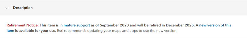
Retiring items also have a Retirement Notice in the item Description to help provide more information, replacement items – if available, and timeline for retirement.
Note for ArcGIS Enterprise Users
If you are using ArcGIS Enterprise 11.4 or earlier, you may see these layers, maps, or apps in searches throughout your Enterprise portal. However, please note that once retired in ArcGIS Online, the underlying content will be inaccessible, and the item will be broken. Therefore, be sure to replace these deprecated items with their newer replacements before their retirement date.
Thank you for your participation in Living Atlas!
In the past year, Esri has published hundreds of layers, maps, apps, and other content in ArcGIS Living Atlas of the World. This work will continue through 2026 and beyond.
As new content is published and earlier versions are replaced, we will periodically move items into mature support and schedule them for retirement at a later date. It is important to occasionally check your web maps and apps to make sure they are using the latest versions of items that are in general availability and update them if needed.
For more information, check out the Esri Product Life Cycle Support Policy.
Thank you for your continued use of Esri content in the Living Atlas—we’re excited to keep empowering your success with innovative and impactful content.

Commenting is not enabled for this article.