ArcGIS Online has been built as an open platform. For some time, ArcGIS Online has supported many established data, metadata, and service standards. This includes KML, Open Geospatial Consortium (OGC) Web Map Services (WMS), OGC Web Map Tile Services (WMTS), and formal metadata standards such as FGDC, ISO 19139, and INSPIRE. A recent release also added support for secure OGC services.
With the latest release of ArcGIS Online, Esri extends its commitment to open standards with enhanced support for OGC services. The following sections detail some of the new enhancements.
Register more OGC services as items
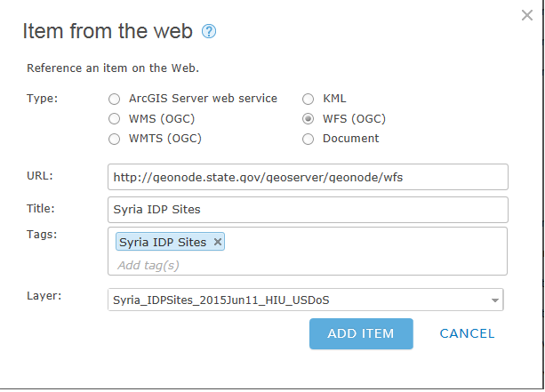
You can now register OGC Web Feature Service (WFS) and OGC Web Map Tile Service (WMTS) services as items, in addition to WMS and KML services. This allows organizations to use and share more of their OGC services as layers in maps and apps.
Pop-ups in OGC WMS layers
You can now enable pop-ups on WMS layers where the WMS service supports it. While this may seem like a fairly simple enhancement, we carefully considered the best user experience before implementing it. The OGC WMS specification does not strictly enforce the formats returned by the getfeatureinfo WMS request. This means that different server implementations of OGC WMS services are at liberty to either support or not support this feature and also many servers support formats that could range from simple text or HTML to JSON or Geography Markup Language (GML). Given the wide variety of supported formats, the identify operation uses HTML if available to display the attribute information. If HTML is not available, it displays the attribute information “as is” within the pop-up.
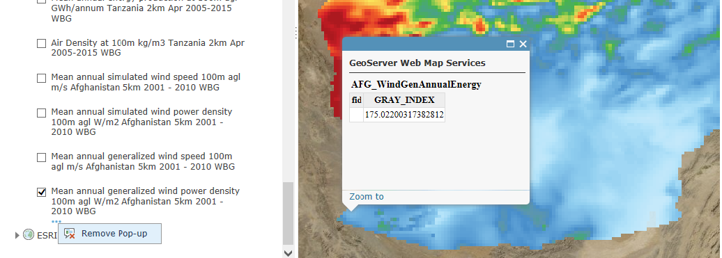
Click here to see a sample web map with WMS layers with pop ups.
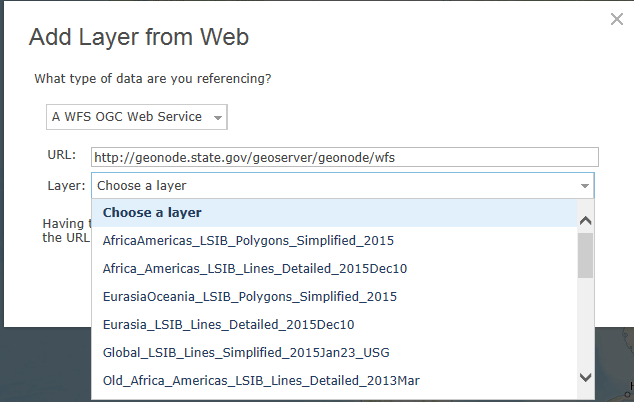
Add OGC Web Feature Service (WFS) layers
It is now possible to add OGC Web Feature Service (WFS) layers to maps. OGC WFS services return features formatted as GML. ArcGIS Online supports WFS versions 1.0, 1.1, and 2.0 and allows most versions of GML (following the simple features profile) to be consumed. It is important to note that while you connect to a WFS service, you will need to explicitly select a layer within the WFS service to add. WFS services are harder to support compared to WMS services because of wide variations in GML implementations and the different tags used by the different WFS versions. A lot of these considerations went into our design of the software and we expect that we will continue to fine tune this implementation over the coming releases. The WFS implementation also allows for some advanced tuning to ride over some of the known difficulties associated with many WFS services. For example, users can limit the number of features to bring in when connecting to a WFS service that supports a very large number of features. When connecting to WFS services that do not implement axis order correctly, it is now possible to have the map viewer flip the axis order on the client side. These types of pragmatic additions make the WFS layer tool very powerful.
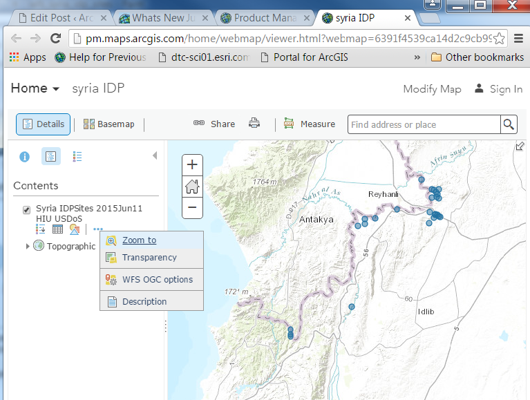
Click here to see a sample WFS layer in a web map.
What’s special about OGC support in ArcGIS Online?
Our goal is to treat OGC layers—KML, WMS, WFS, and WMTS —like any other web service. We want web maps that contain these OGC layers to behave similarly to any other web map and to be supported in a variety of web clients such as configurable apps, Web AppBuilder, Operations Dashboard etc. Let’s take the WFS layer as an example. WFS administrators can now create WFS layers in their organization and share them out across the organization for use in web maps and apps like Web AppBuilder, Story Maps, and other configurable apps. Layers shared this way are easily consumable by others in the organization without even knowing that they are in fact powered by a WFS service. WFS layers are backed by real data. This data can be configured into real information through pop-ups, simple styling, and labeling. The layer’s information can also be explored through the tabular view in the map viewer and can be used in all of the online analysis tools. So to reiterate, our goal is to treat OGC layers like any of the other web service layers.
What’s next?
All the new functionality discussed in the context of ArcGIS Online will be available in the upcoming release of ArcGIS 10.5 for Server.
We are also implementing solutions for hosting OGC services in both our cloud (ArcGIS Online) and for use in portals running in your infrastructure. By hosting, we mean providing you the ability to use your hosted data to spin up WMS and WFS services right within the portal environment.
We understand that there are still gaps in our support for OGC and other open standards. It is important to be aware that while ArcGIS continues to evolve, so do many of the open standards. We will keep working with as many of the new and updated specs as we continue to stay committed to open standards and interoperability. As you start using these new implementations, please provide us feedback – good and bad. We want our software to be reliable, useful, and easy to use, so let us know what’s working and what’s not. Please contact us if you run into issues with OGC servers and services and we’ll investigate what’s going on. We are excited to offer these OGC enhancements and look forward to hearing from you!

Article Discussion: