The December 2018 release for Scene Viewer includes many new features and enhancements that we just can’t wait to see what you create with in ArcGIS Online. If you haven’t had the chance to check out our September 2018 release blog, please check it out to learn how to use feature search to locate features within your web scene and gamepad support to help you easily navigate in your web scenes.
Support for Large Lines and Polygon Datasets
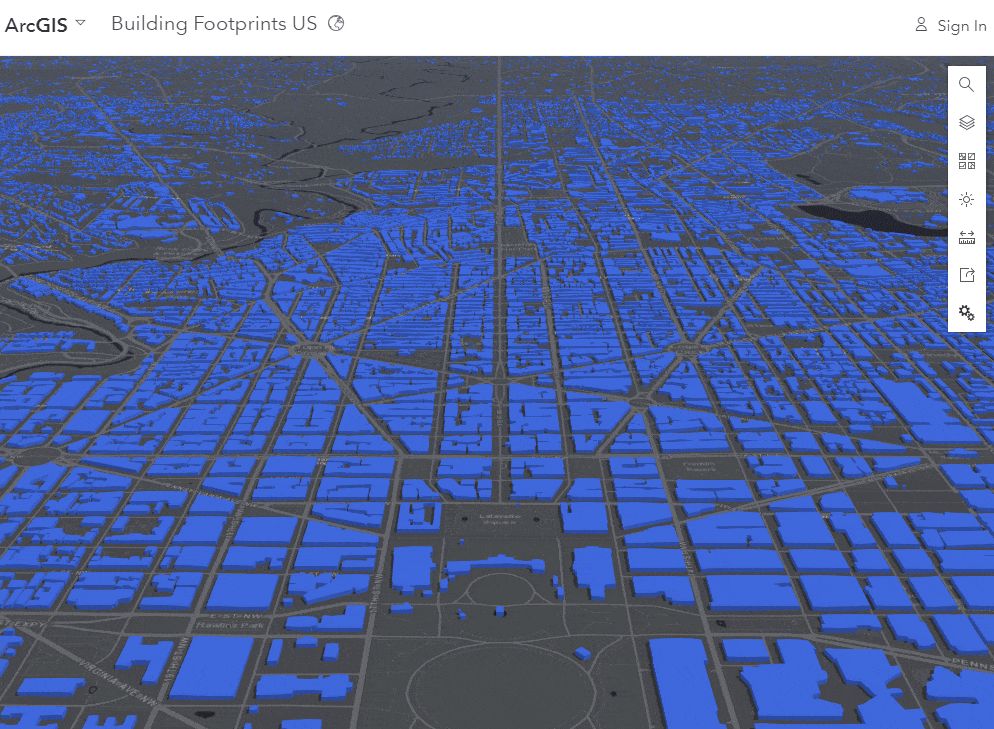
Scene Viewer now supports very large line and polygon feature layers added to your web scene. This means that together with the support for displaying large point datasets added in the July 2018 release, you are no longer restricted to the 2000 feature limit for any of the supported geometry types in Scene Viewer. Use this to display roads, rivers or county parcels in your scenes. The scene below is displaying only one feature layer with 125 million building footprints! Click here to check out the scene.
Enhancements to Large Point Dataset
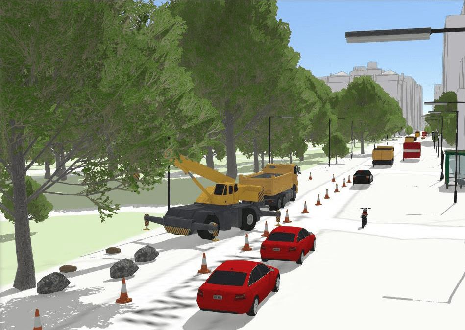
In this release we introduce automatic level of detail support for our 3D Realistic Trees, Street Scene and Transportation symbols. This enhancement greatly improves the performance and stability of your scene by changing the level of detail shown in the 3D symbols depending on how near or far away you are to the feature. For example, when you are far away from a tree you do not need all the detail of the leaves and branches but as you get closer this detail will be displayed, however this is fine-tuned so it is not very noticeable. We have also improved the performance and experience of point layers in scenes in general, improving the performance and displaying more data within your scene, always dependent on the Performance-Quality settings chosen. Click here to open the scene.
Building Scene Layer
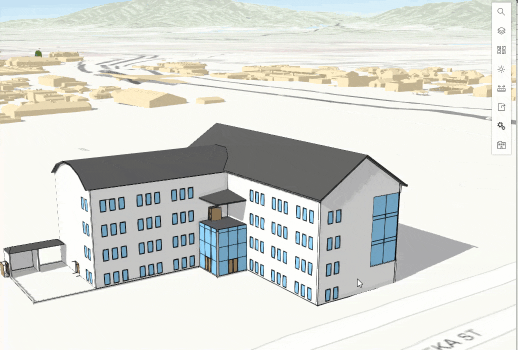
With this release of ArcGIS Online we are introducing the Building Scene Layer. The Building Scene Layer can display complex digital models of buildings, including details like interior and engineering elements, coming from BIM datasets. You will be able to create scene layer packages from Revit files with the upcoming release of ArcGIS Pro 2.3. We offer a unique experience with the building scene layers where you can easily display individual discipline layers, such as structural or architectural, or categories, such as walls or roofs. Read more about the Building Scene Layer here. Explore the scene by clicking here.
New Slice Tool
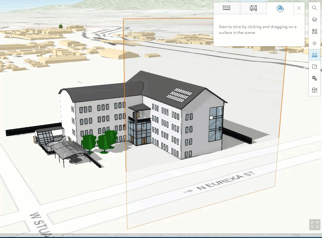
Before this release we had the measure area and length tools available for you to use in your scene. You can now use the new slice tool along with the measurement tools. The slice tool temporarily suppresses parts of your scene to expose hidden content. For example, you could have a complex digital model of a building that has a cold and hot water piping contained within it. When you view the exterior of the building you cannot see those pipes without adjusting the layers visibility that could be obstructing the view of the pipes. You can now use the slice widget to suppress the shell of building along with other layers to easily reveal the pipes within. You can read more about this new tool here.
Filtering Features
With this release of Scene Viewer, you can now apply attribute-based filters in the new Layer Properties UI. This new capability is available for feature layers and scene layers, including point cloud layers. Just open the context menu of a layer in the Designer and click on the Layer Properties option. Just like definition expressions but with a simplified user experience, filter your features using unique values or a range of values depending on the field type. This can be very useful for finding specific content like buildings built in a specific year or hiding parts of your point clouds by classification code, like ground or vegetation. Read more about it here.
New Add Layer Experience
The user experience for adding layers to your scene has been enhanced and now mirrors the experience you have in Map Viewer today. Easily search for layers that are in the Living Atlas. Easily see what content is authoritative and available through your subscription with this new Add Layer experience. You can filter and sort content to help you find what you need in your scene. Clicking on the title of the layer will show you the detailed item view of your content so you can read more about what you are adding into your web scene. Learn more here.
Miscellaneous Enhancements
- Use custom images for 2D icon symbols. Learn more about styling your points here.
- Improved navigation in global views.

Commenting is not enabled for this article.