The April 2021 ArcGIS Online update introduces new features and key updates throughout the site. The same applies for Configurable Apps, as we have introduced a new generation of web mapping apps, added enhancements to existing apps and the new app configuration, and addressed various bugs to help stabilize and improve your experience across the site. We have also released a new beta app that presents and showcases a series of maps, apps, and other content types. See the highlights below.
Instant Apps gallery
The next generation of web mapping apps is available in ArcGIS Online. Introducing: Instant Apps. Recently we developed a new app configuration with highlights such as Express Setup, updates on the fly, mobile device preview, Web Analytics, and more. This configuration and the new Instant Apps are localized to support many languages and also are accessible for people who use assistive technologies. This release introduces a more efficient way to choose, configure, and use Instant Apps.
From the new map viewer, click the Create app button in the left side panel and choose Instant Apps to launch the new gallery. Designed to make choosing an app easier and more successful, this new gallery features all of the apps that take advantage of the new app configuration. The apps are initially sorted on the Browse All tab based on compatibility with your web map (shown behind the gallery of app choices). Apps that your map and data are compatible with are sorted first in the gallery. Use Search to search apps by capabilities. For example, search for “bookmarks” and only apps supporting the use of bookmarks will return in the results.
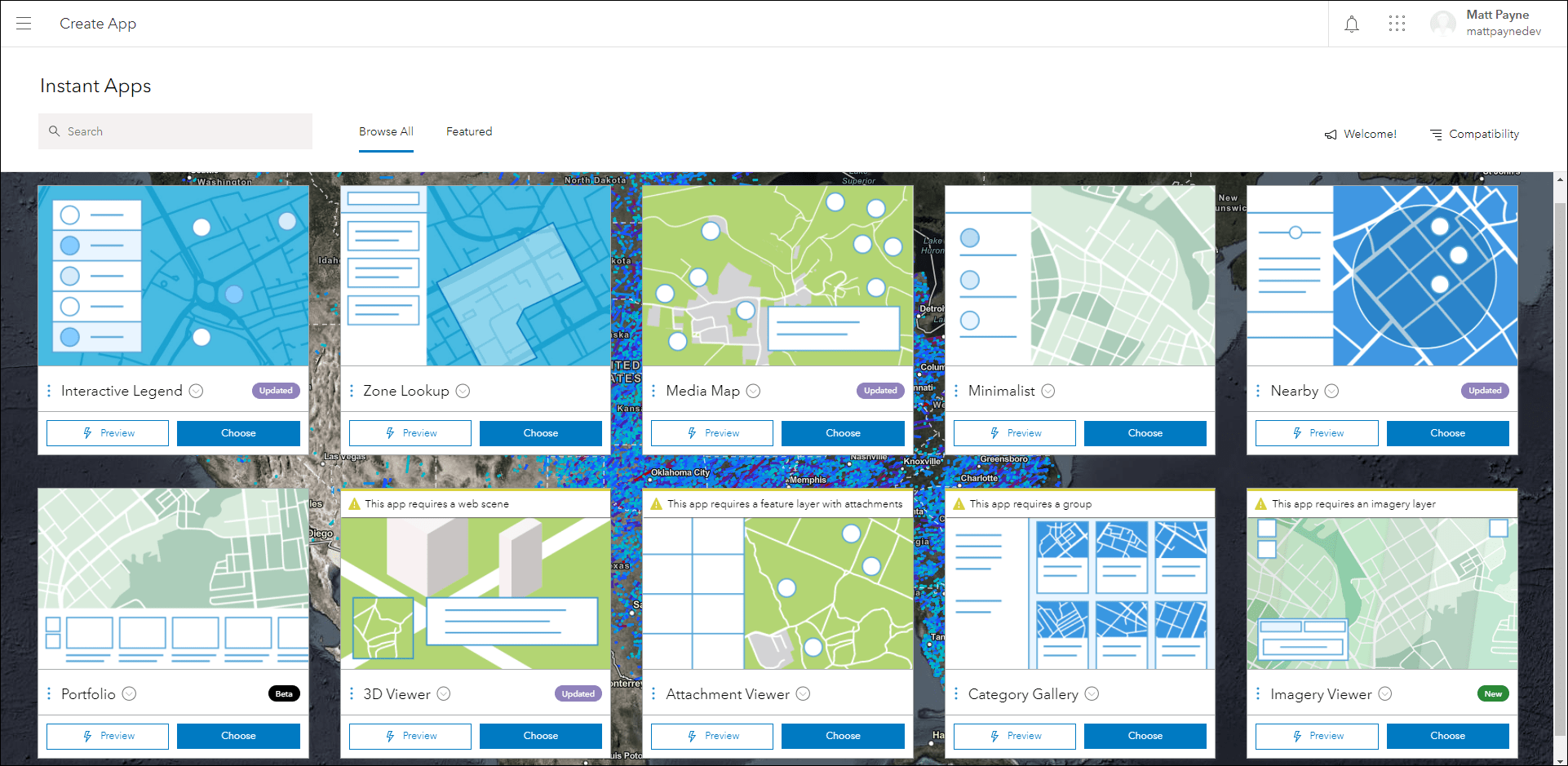
Badges are applied to apps referencing if a choice is new, updated, or in beta. The Featured tab shows a filtered list of apps that are trending or popular. Publish an app instantly by clicking the Publish button from the app preview, or click Configure App to enter the Express Setup.
For a complete and detailed introduction to Instant Apps and the highlights mentioned above, check out our Introducing ArcGIS Instant Apps blog.
Introducing: Portfolio (beta)
Portfolio (beta) is a new Instant App that showcases different types of ArcGIS Online content all in one place. This lets you curate multiple types of resources related to a specific topic in a single app solution. When configuring the app, use the Portfolio section to create and reorder content that app viewers will interact with including maps, apps, and scenes. App viewers can choose items to interact with from the navigation bar or choose auto-play to move through content automatically. Enable the Map location option in the app configuration to let app viewers input a location that will be used as the focused starting point for each map and scene item in the navigation bar.
For a detailed introduction to exploring and using Portfolio (beta), please check out our Introducing Portfolio (beta) blog.
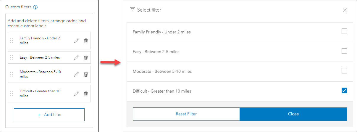
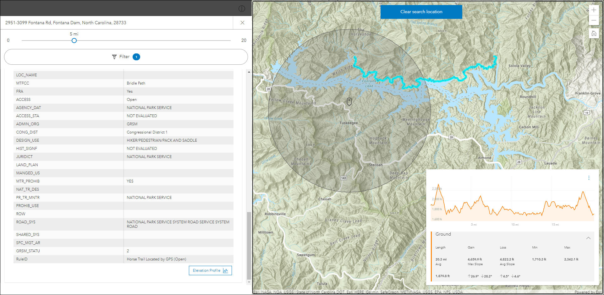
Attribute filtering in Nearby
Nearby offers the ability to discover features that are closest to a searched location. Create a testing facility app where people can use their address to find out which COVID-19 testing facilities are near them. Configure a camping app to find out which campgrounds have the shortest drive from home.
New with this release is the ability to filter results using attributes. For the campground example, after finding which campgrounds are closest by, use attribute filtering to further filter the results to show only campgrounds that are open in May and have running water. The information for the dates of operation and water availability would come from the data layers in the map, and creating the filters would take place in the app configuration on the Interactivity > Filter tab.
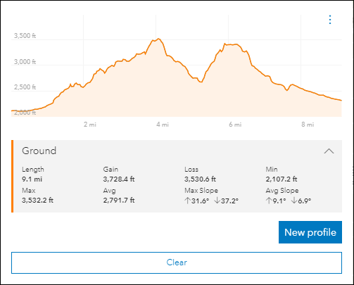
Furthermore, the new Elevation Profile tool has been added to Nearby (highlighted in a later section of this blog). If your results feature layer contains features with a line geometry type, this tool can be used to generate an elevation profile graph for line features contained in the results panel. For example, create a trail finder app using Nearby to discover trails that are close by, filter the trails by difficulty level using the new attribute filters, and then check out the route’s elevation change by clicking the Elevation Profile button.
For more details please check out our Refine results with Filters in the Nearby Instant App blog.
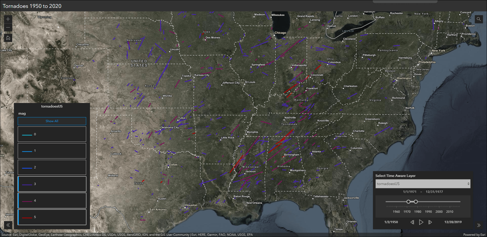
Time filtering in Interactive Legend
Interactive Legend allows users to visualize features on a map by interacting directly with legend elements to select different classifications of features. This release introduces the ability to filter features using time-enabled layers. Use the time slider in the app to visualize features that occur within a specific time range, and then use the legend to further filter the data based on the selected criteria. For example, if you were analyzing historical tornado tracks across the US, you could use the time slider to show just tornadoes that occurred in the 1970s and then use the legend to filter by tornadoes with a magnitude of 3 or greater.
Elevation Profile tool
We have integrated a new elevation profile tool into three Instant Apps including 3D Viewer, Media Map, and Nearby. This tool generates an elevation profile graph across an input line feature that can be selected in the map, or from drawing a single or multi-segment line using the widget. Utilize this tool for choosing hiking trails based on difficulty, assessing walking routes to and from close by bicycle racks, determining the best route for firefighting crews to approach wildfires on hilly terrain, and more.
Generate a profile across terrain in a web scene by using this tool in 3D Viewer. Use Nearby to find out what hiking trails are close by, filter the results by length or difficulty (mentioned in an above section), and view the elevation profile for further details.
Imagery Viewer migrated to the new app configuration
We have migrated Imagery Viewer to the new app configuration. Imagery Viewer allows you to visualize and explore imagery through time and space. This app includes tools for navigating through time, recording locations, measurement, and more. Non-imagery layers are supported as well as editable feature layers for annotation. Imagery Viewer supports both a one-image configuration for focusing on a single imagery layer, as well as a two-image configuration that lets users compare two imagery layers using a swipe tool. Image measurement is supported for imagery layers that have mensuration capabilities.
The updated app configuration offers new functionality such as Express Setup, updates on the fly, the ability to search for settings, mobile device preview, and Web Analytics. Refer to our June 2020 What’s New blog for more details: What’s New in Configurable Apps (June 2020): Introducing the New App Configuration


Article Discussion: