Update data is a widely used tool in ArcGIS Online to update and maintain data. Now with the November 2026 update, there is a new method in Update data to delete all existing features (or records) on a layer and replace it with the data contained in your source file or feature service. Read on to learn more about this new workflow and if it is right for your data needs.
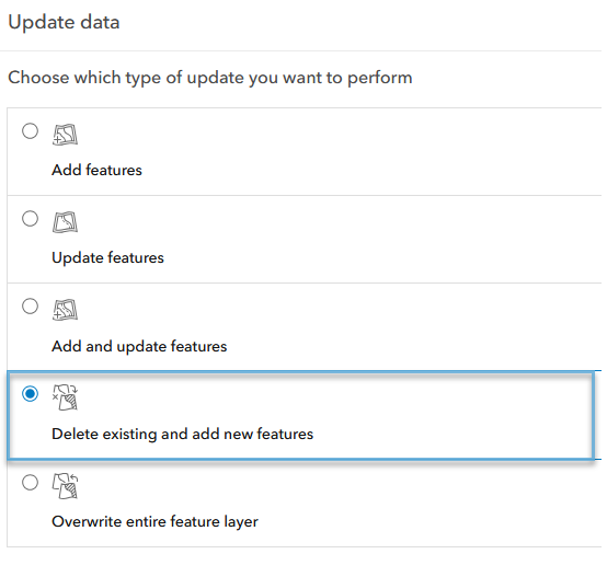
Aptly named, Delete existing and add new features will delete* everything in the chosen layer or table and completely replace it with the data in your source file or source feature layer. This is different than Update data‘s existing workflows (excluding overwrite) which only add or update data, never removing any features or records. If you have used the Add features workflow, the experience is nearly identical for Delete existing and add new features. Simply provide the source file or feature service, opt into any additional settings, then match the fields between the source and destination layers. Update data will take care of the rest!
*For our ArcGIS REST API savvy users, “delete existing and add new features” leverages truncateExisiting to delete all the existing features (or records) in a hosted feature service. Then, it adds in the new data from the source file or feature service.
See the table below for a breakdown of each workflow and when you should use it in your routine updates.
Update data method |
When should I use it? |
|
Add features
|
Add features inserts new data into your hosted feature layer. This workflow has no way to detect matching features, so it is best suited for entirely new data. If a field is unmatched and it has a default value configured, the new features will contain the default. |
|
Update features
|
Update features changes the attributes and/or geometry of your data. It requires a unique identification field to pair incoming data with what is in your hosted feature layer. This is ideal for routine updates to existing features, and removes the risk of accidentally adding in new features. |
|
Add and update features
|
Add and update features combines both of the workflows above. It inserts new features and updates the attributes and/or geometry of your preexisting data. As with updating features, Add and update features requires a unique identification field. This option works well for routine updates where you want to keep existing features up to date and include new features as well. |
|
Delete existing and add new features*
|
Delete existing and add new features replaces all the features in a layer with data uploaded from the source file or feature service. This is more stable way to completely replace all the data within a feature layer without risking downtime for the service.
The ObjectID field is reset to 0 after deleting existing features. If a field is unmatched and it has a default value configured, the new features will contain the default. |
|
Overwrite entire feature layer
|
Overwrite entire feature layer deletes the ArcGIS Online hosted feature service and replaces it with the data in your source file. The file name and schema must match before overwriting. This will delete all layers and data, and may cause downtime on the service. |



* New method as of November 2026
There are numerous methods to update your data in ArcGIS Online, and the introduction of Delete existing and add new features only enhances your options. Whatever workflow or method you use to update your data, happy mapping!

Commenting is not enabled for this article.