Our internal development teams have been working very hard building a world class GIS API with the Runtime Quartz release. With our ultimate milestone reached and our latest SDKs released to the world, we wanted to take a step back and have our developers use the API to build an app. We setup an internal hackathon and asked our developers to show how to use our platform in a simple, clear way to solve a real-world problem.
The Runtime Quartz Hackathon was held over two days in December. A total of 41 people registered and organized into 9 teams. Teams were asked to show off their ArcGIS knowledge and app building acumen. They each demonstrated Runtime apps that exhibit best practices and the features that separate our technology from our competitors.
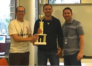
The teams competed for the best app overall and top prize in categories Consumer, Civic, and Enterprise. At the conclusion of the hacking each team prepared a 5-minute presentation to demonstrate their app and solution to our 4 judges. We awarded a trophy to the overall winning team and lots of Esri swag to all the category winners.
Here we present a summary of the hackathon project submissions. Each project is highlighted in our gallery where you can learn more. Each gallery entry has a link to the source code on github.
Drift
Best overall app
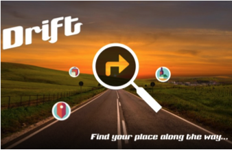 Have you ever been on a long drive and needed a cup of coffee? Or maybe you want to plan a stop in a few hours and want to know where you will be? You don’t want to start exiting the freeway randomly and you don’t want to find something that’s out of your way. Search places along your route, plan stops, breaks, search by rating, price, deals and more.
The tech: ArcGIS iOS SDK, Yelp API.
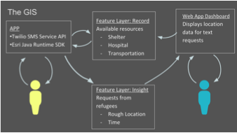
R.A.P.
First prize Civic
 Refugees Assistance Provider implements a GIS to connect refugees with services while providing aid workers information about their location and needs. Using SMS (or native app), displaced persons can receive information and routing to services provided by local aid organizations. Aid workers can track general locations and movements of people through time as they access the GIS.
The tech: ArcGIS REST API, ArcGIS Pro, ArcGIS Online, ArcGIS Android SDK, ArcGIS Living Atlas, Web AppBuilder, Twilio API.
Hey, what’s that?
First prize Consumer
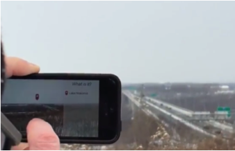 This is an Augmented Reality (AR) app that aims to answer the question, “Hey, what’s that?” This could be used for peaks in a mountain range, parks and other points of interest from a vista point, or skyscrapers in the downtown area of a city. A typical use case would be that a user wants to know what something is in the landscape they are looking at, so they:
- Get out their phone and open the app
- They will be presented with a view that displays the camera output
- They tap on the thing they would like to identify
- A screen overlay appears over the camera output, identifying what they tapped on
The tech: ArcGIS iOS SDK, ArcGIS Pro, ArcGIS Online.
Deliver ’til you drop
First prize Enterprise
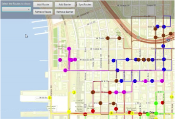 This project is used to generate delivery routes for a number of employees. Routes will be downloaded to the delivery person’s mobile device daily. The current route to the next destination will be displayed on a map and will be updated to the next route once the item is delivered. Obstructions can be added in real-time, either by back office staff or by delivery staff. Obstructions are things like traffic jams, road works, or otherwise impassable routes. As these are updated on each delivery person’s device, their route will be updated.
The tech: ArcGIS Java SDK, ArcGIS Android SDK.
OK! Map
Runner-up Consumer
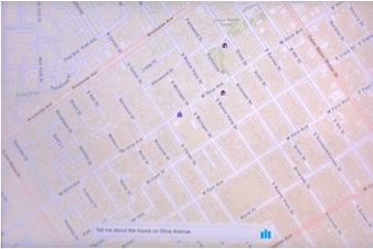 Our beautiful and intelligent map helps with curated lists in a way you have never experienced before – by using voice recognition. Our map is capable of providing data like list of houses for sale around a school you wish your kids could attend. It can do many more things as long as you have related data.
The tech: ArcGIS iOS SDK, Apple SpeechKit.
Disease correlator
Runner-up Civic
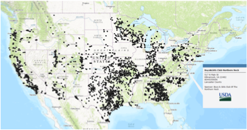 Studies done in New England and Guam that showed a correlation between water toxins and diseases. Would like to help other researchers find similar correlations around the country. The app shows geographic concentrations of patients in relation to toxins.
The tech: ArcGIS .NET SDK, ArcGIS Online, ArcGIS Pro.
PlantR
Consumer
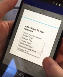 In the Portland office we have a number of indoor plants that require different levels of care, which is a project in itself. This app will make it easier! Using a DIY-connected moisture sensor and indoor maps, plant location and care history will be easier to manage.
We started with a concept about integrating an Arduino moisture sensor and indoor location tracking. We leveraged the IndoorAtlas SDK to track indoor locations. This required us to create a floor plan using Indoor Atlas tools. The floor plan was a way to calibrate our indoor location tracking sensors (using a device’s accelerometer, gyroscope, wifi, and compass). GPS was not used.
The tech: ArcGIS Pro, ArcGIS Android SDK, Arduino SDK.
Map your photos
Consumer
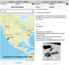
There are an increasing number of location enabled social media applications on mobile devices. This project is a proof of concept that demonstrates how we can utilize the ArcGIS platform to visualize photos with location data.
“Map your photos” is a mobile application targeted to the consumer iOS platform. Photos are pulled from the Flickr API and plotted on a map to provide geographic context to pictures for data visualization purposes. We also used ArcGIS Online to store map information for later use.
The tech: ArcGIS iOS SDK, Flickr API, ArcGIS Online.
ShipWrecked
Enterprise
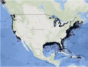 Use the awesomeness of ArcGIS Runtime Android SDK, ElasticSearch and ArcGIS Online to create a search based location retrieval of NOAA recorded shipwrecks. Allows easy search, retrieval, display and syncing of client-generated maps to ArGIS Online.
The tech: ArcGIS Android SDK, ArcGIS Online, Elastic Stack.
The hackathon was a resounding success. We were truly energized to see the application of the ArcGIS platform and the various technology integrations. These unique projects will inspire others to leverage the ArcGIS platform in new ways. We wish to thank all our teams for participating and their commitment to doing great work, and our esteemed judges for their time and expertise.

Article Discussion: