
This article was originally published on November 3, 2025, and has been revised to reflect enhancements made in the 2026 February update.
Applying the appropriate format to your field values is a small but important step to achieving a polished web map. Because date and number format preferences differ so much throughout the world, it’s important to ask yourself “who is viewing my map?”. When you know the “who” you can make an informed decision on what format is the best fit for your situation.
With the October update of ArcGIS Online, feature layer field formatting has been improved to help meet your viewers’ needs by better aligning with internationalization standards. The additions offer improved locale support for date and number fields and introduce new formatting options.
What has changed?
At its simplest, a web map is a JSON file that tells an application how the map should appear and function. The web map specification specifies the rules for this file, allowing different applications to consistently create, update, and display maps. Every web map has three main components: a basemap, operational layers, and tables. The operational layers (which include spatial data) and tables (which contain non-spatial data) link to the data behind the map and define things like style, label, and pop-up configurations.
Field formatting is another configuration stored on operational layers and tables. The October 2025 update added a new property, fieldConfiguration, to the web map specification. It is now the new location for storing field formatting. It’s modeled after the Intl standards, specifically Intl.DateTimeFormat and Intl.NumberFormat, which provide language-aware options for date and number formatting.
This update makes it easier for maps to present information in ways that feel more familiar to users around the world, whether that’s showing dates in a locale-specific format, using region-specific numeric separators, or honoring language preferences. Over time, this foundation change will enable the extension of formatting capabilities beyond dates and numbers, giving map authors even more control over how attribute data is presented across apps and experiences.
Existing maps and apps
Most of your existing field formatting will carry over automatically, though you may notice a few small changes. For example, in the en-US locale, the previous short date format showed a four-digit year, e.g. 3/24/2025. With the new formatting approach, short dates follow international conventions and display with a two-digit year, e.g. 3/24/25. These adjustments help make maps more consistent and easier to read for people around the world.
To maintain compatibility, the previous formatting settings are still preserved. This means maps and layers will appear as expected within older applications that use earlier versions of the ArcGIS Maps SDK for JavaScript. Likewise, when you configure new formatting in Map Viewer, those settings are automatically converted back to the older format upon saving – so your maps look great no matter which app or version they’re viewed in.
New formatting support
Currently, field configuration (fieldConfiguration) is limited to feature service-based layers and tables (since October 2025) as well as feature reduction, clustering and binning, fields (since February 2026). Other layer types, data sources, and Arcade attribute expressions are not yet supported but are planned for an update in the near future. In these cases, dates and numbers will display as they did before the October 2025 update.
Formatting options
Locale improvements
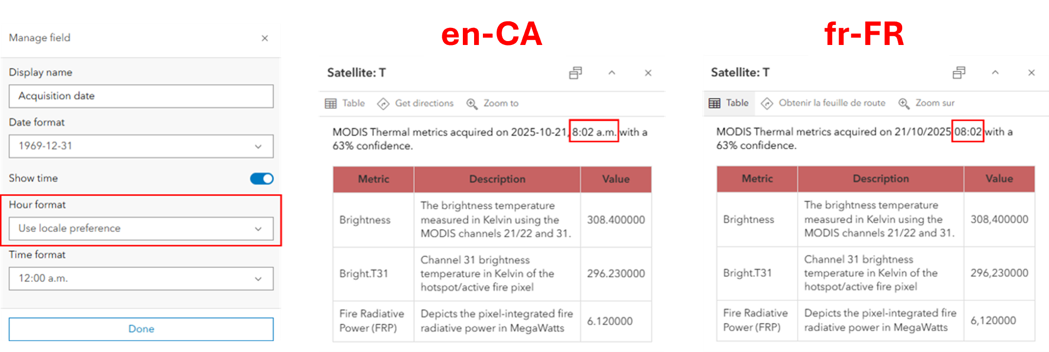
As mentioned at the beginning of this blog, the way dates, times, and numbers are formatted varies a lot throughout the world. The updates to field formatting make accommodating this as simple as selecting the “Use locale preference” option in a dropdown. When leveraged, these new options will dynamically change the date and number format style based on the viewers’ locale. This is incredibly useful if your map is viewed globally.
If a viewer is signed into ArcGIS Online, the formatting style is based on their language and region profile setting (see this link for more details). If a viewer is not signed into ArcGIS Online, field formatting is based on the browser language settings.
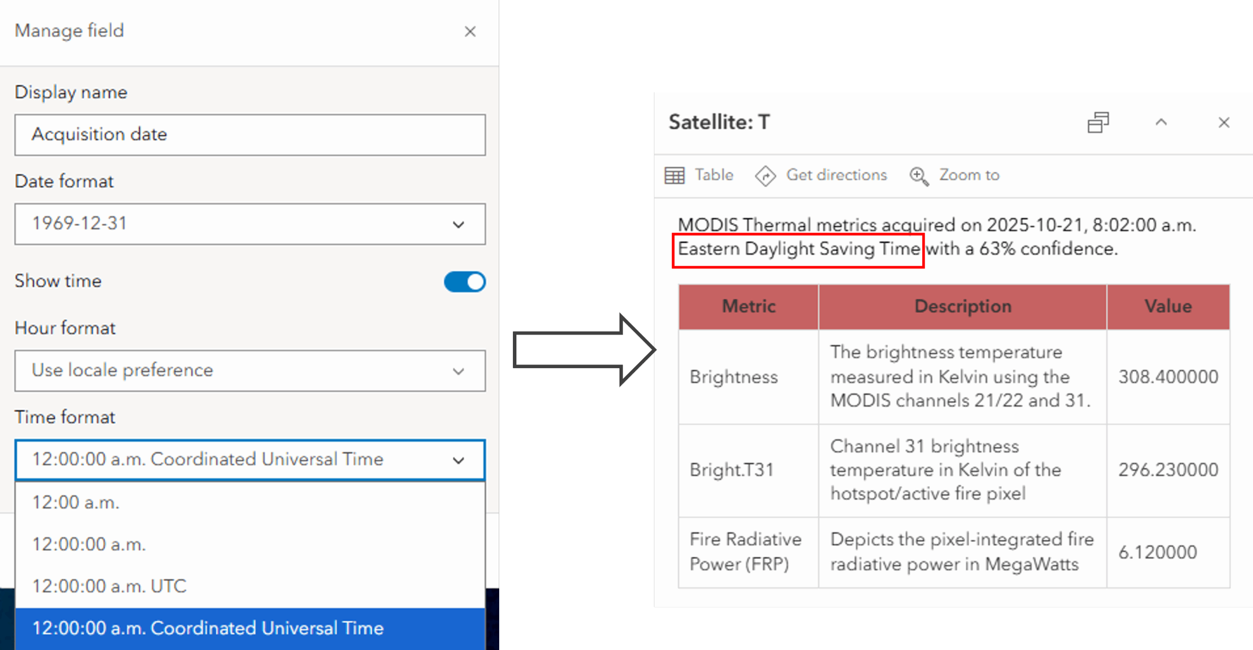
Hour format
When working with date, timestamp offset, and time only fields, you can set the hour format. This option specifies whether the time will display in a 12-hour or 24-hour format. You can force the time into either 12 or 24 hours, or the hour format can be set to dynamically change based on the viewers’ locale.
Thousands separator
When working with numeric fields, you have the option to display a thousands separator. Like hour formatting, you can choose to dynamically apply the separator style based on the viewer’s locale.
Display time zones
Time zones can now be shown, fully or abbreviated, as part of the time format of date and timestamp offset fields. The time zone will change based on the web map time zone setting. Displaying time zones is useful when sharing data with viewers across different time zones.
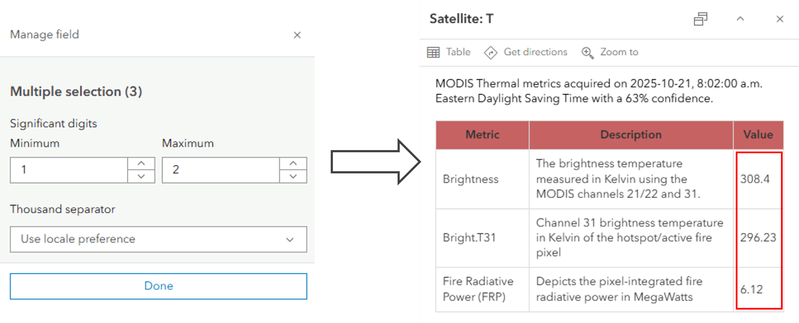
Significant digits
Controlling the display of significant digits on double fields isn’t new, but now you have greater control by being able to specify the minimum and maximum number of significant digits. This means avoiding trailing zeros if the precision level varies within a double field.
What’s next?
These updates to field formatting are part of our continued commitment to making maps more intuitive and consistent, and above all, globally aware. Improved date and number formatting means Map Viewer provides a more natural experience for users everywhere. And we’re just getting started; future updates will continue to expand localization and formatting options, helping your maps look great no matter where they’re viewed.
Try out the new formatting options in Map Viewer today and see how your maps adapt seamlessly to every locale.

Commenting is not enabled for this article.