Display filters are now supported in Map Viewer with the ArcGIS Online February 2025 release. Using display filters on your layer is a great way to add to your layer’s performance on the map. With this release, you can author scale and manual type display filters in ArcGIS Pro and use them in your web map in Map Viewer. For those not familiar with display filters, they are different from the feature filtering experience in Map Viewer. Display filters will only remove features from the display. All features are still available in the table or for analysis. They are also great for only having to manage one layer but having different features display at different scales. When using feature filtering in Map Viewer those features are not available in the map, table, styling and analysis.
Authoring and using display filters.
When authoring display filters in ArcGIS Pro a layer can have one type of display filter applied at a time.
Scale Display Filter
The scale-based display filter will have scale ranges with a defined filter expression for each range. As you interact with the map and change the map scale, you will see features displayed or removed from the map view depending on the filter expression for that scale range. This type of display filter is great for dense data, where at certain scales, it makes sense to display more prominent features, and as you zoom in, features of other priorities are displayed.
Building a Scale Display Filter
In ArcGIS Pro select the layer you want to add a display filter on.
There are two ways to get to the display filter panel.
1.On the Feature Layer ribbon under the Symbology section, click on the display filter icon.
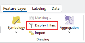
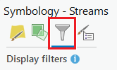
2. Open the Symbology panel, you will see a filter icon. Clicking on this will bring you to the display filter panel.
Next, click on Enable display filters. The scale display filter is the default type that will be enabled.
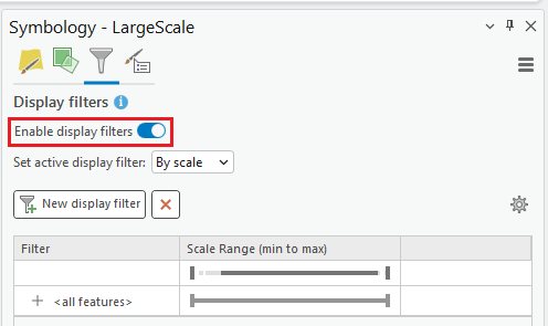
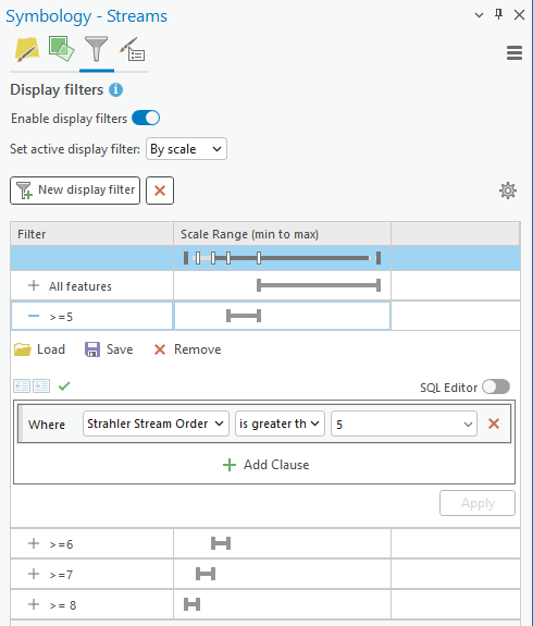
The <all feature> display filter will be present when a new display filter is created. Clicking on the topmost scale range slider can adjust the range for the all feature display filter. The name can be updated, along with adding a new expression.
Clicking on the New display filter button will add a display filter below it along with adding a new slider handle to the top most scale range. Similar to the all feature display filter you can adjust the range and expression for this display filter. For this example, layer I set the scale display filter on stream order so as you zoom into the map more streams of lower order are displayed.
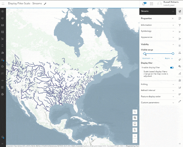
Once the display filter has been completed the map can be shared to ArcGIS Online and Opened in Map Viewer. The display filter will be active and you and see zooming in the display filter adjusting for the map scale. Opening the layer properties panel, you can control if you want the display filter to be active on the layer or not.
Manual Display Filter
Manual display filters allow the viewer of the map to pick an active display filter and are not dependent on scale. The filter expressions are exclusive to one another and only one can be active at a time. This type of display filter is great for visual comparisons of features within your layer.
Building a Manual Display Filter
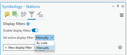
Manual display filters are available on the same panel where the scale-based steps are outlined. When on the display filter panel, the type of active display filter can be switched from scale to manual by clicking on the available dropdown.
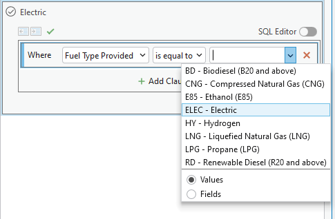
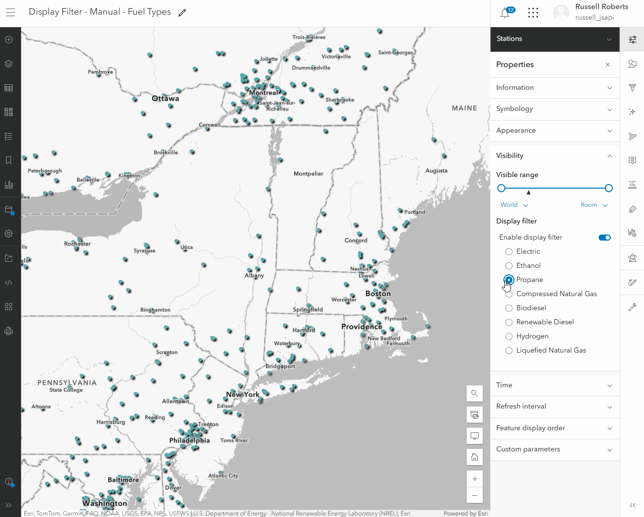
Similar to the scale display filter an all features filter is present. This can be edited by defining a new expression on the display filter. It is important that a name is added so the viewer of the map can understand what features are filtered out. Adding more filters is done by clicking on the New display filter button. In this example, I am adding a simple display filter on the field containing the energy station fuel type. We can easily compare the fuel types available on this layer one at a time.
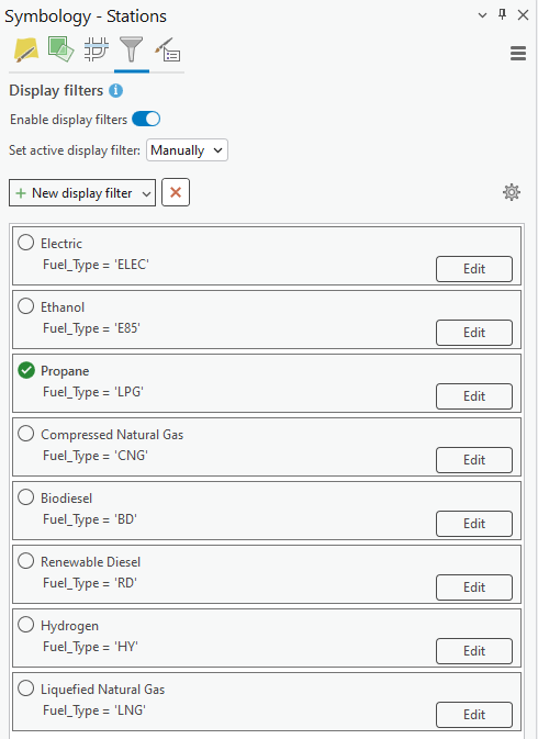
Below is an image of the final list of display filters authored where the viewers of the map will have multiple energy types to pick from.
Share the final map to ArcGIS Online and open the map in Map Viewer. On the layer properties panel, you will see under the display filter section all the filters created. Clicking on a filter will set the active display filter. The top-level toggle on the display filter section in the panel will also enable or disable it completely on the layer.
This wraps up display filters in Map Viewer. We are working on sharing this functionality with other apps in the coming releases and bringing the authoring experience to Map Viewer.

Commenting is not enabled for this article.